Fitxer:Nya Sverige.svg

Mida d'aquesta previsualització PNG del fitxer SVG: 342 × 599 píxels. Altres resolucions: 137 × 240 píxels | 274 × 480 píxels | 439 × 768 píxels | 585 × 1.024 píxels | 1.170 × 2.048 píxels | 720 × 1.260 píxels.
Fitxer original (fitxer SVG, nominalment 720 × 1.260 píxels, mida del fitxer: 461 Ko)
| Aquest fitxer i la informació mostrada a continuació provenen del dipòsit multimèdia lliure Wikimedia Commons. |
Resum
| Descripció |
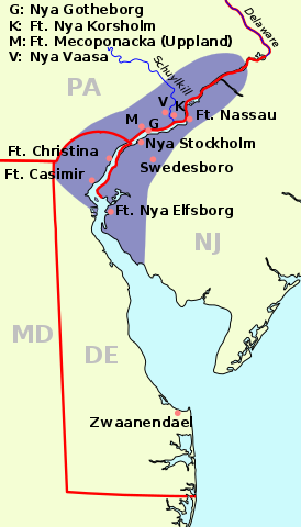
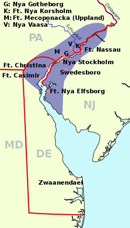
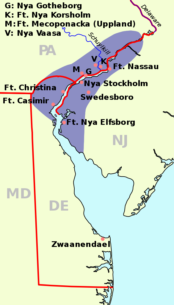
English: The map of New Sweden, 1638 Deutsch: Karte von Neu-Schweden, 1638. Русский: Карта Новой Швеции, 1638 год |
||
| Data | (UTC) | ||
| Font | |||
| Autor |
|
||
| SVG genesis | El codi font d’aquest SVG no és vàlid perquè hi ha un error. Aquesta imatge vectorial ha estat creada amb un editor de text.
|
| See also: Nieuw Nederland and Nya Sverige |
Aquest fitxer està subjecte a la llicència de Creative Commons Reconeixement i Compartir Igual 3.0 No adaptada.
- Sou lliure de:
- compartir – copiar, distribuir i comunicar públicament l'obra
- adaptar – fer-ne obres derivades
- Amb les condicions següents:
- reconeixement – Heu de donar la informació adequada sobre l'autor, proporcionar un enllaç a la llicència i indicar si s'han realitzat canvis. Podeu fer-ho amb qualsevol mitjà raonable, però de cap manera no suggereixi que l'autor us dóna suport o aprova l'ús que en feu.
- compartir igual – Si modifiqueu, transformeu, o generareu amb el material, haureu de distribuir les vostres contribucions sota una llicència similar o una de compatible com l'original
Registre original de càrregues
This image is a derivative work of the following images:
- File:Nya Sverige.png licensed with Cc-by-sa-3.0-migrated, GFDL, PD-self
- 2005-10-12T00:50:54Z Arnapha 306x528 (6492 Bytes) Map of New-Sweden ca. 1650 Created on base of the maps of Delaware and New Jersey from the Perry Castañeda Library (at http://www.lib.utexas.edu/maps/united_states.html). Transferred from German Wikipedia (http://de.wikipe
- File:USA New Jersey location map.svg licensed with Cc-by-3.0, GFDL
- 2009-06-17T19:59:27Z Alexrk2 839x1560 (259806 Bytes) enh
- 2009-06-13T18:01:16Z Alexrk 839x1560 (198653 Bytes) fixed SVG bug
- 2009-06-13T17:46:17Z Alexrk 839x1560 (246056 Bytes) == Beschreibung == {{Information |Description= {{de|Positionskarte von [[:de:New Jersey|New Jersey]], [[:de:USA|USA]]}} Quadratische Plattkarte, N-S-Streckung 130.0 %. Geographische Begrenzung der Karte: * N: 41.6° N * S: 38
- File:USA New York location map.svg licensed with Cc-by-3.0, GFDL
- 2009-06-10T11:28:20Z NordNordWest 1572x1277 (597043 Bytes) {{Information |Description= {{de|Positionskarte vom Bundesstaat [[:de:New York (Bundesstaat)|New York]], [[:de:USA|USA]]}} Quadratische Plattkarte, N-S-Streckung 135 %. Geographische Begrenzung der Karte: * N: 45.3° N * S: 4
- File:USA Delaware location map.svg licensed with Cc-by-3.0, GFDL
- 2009-06-22T10:54:18Z Alexrk2 470x800 (106507 Bytes) renderer bug
- 2009-06-22T10:39:54Z Alexrk2 470x800 (66078 Bytes) == Beschreibung == {{Information |Description= {{de|Positionskarte von [[:de:Delaware|Delaware]], [[:de:USA|USA]]}} Quadratische Plattkarte, N-S-Streckung 130.0 %. Geographische Begrenzung der Karte: * N: 40.0° N * S: 38.3°
Uploaded with derivativeFX
Historial del fitxer
Cliqueu una data/hora per veure el fitxer tal com era aleshores.
| Data/hora | Miniatura | Dimensions | Usuari/a | Comentari | |
|---|---|---|---|---|---|
| actual | 10:23, 1 gen 2011 | | 720 × 1.260 (461 Ko) | Arnapha | adapted size |
| 08:05, 1 gen 2011 |  | 730 × 1.270 (461 Ko) | Arnapha | moved origin | |
| 08:01, 1 gen 2011 |  | 730 × 1.270 (461 Ko) | Arnapha | use total viewBox | |
| 07:12, 1 gen 2011 |  | 1.020 × 1.760 (461 Ko) | Arnapha | text position | |
| 06:18, 1 gen 2011 |  | 1.020 × 1.760 (461 Ko) | Arnapha | removed unused items | |
| 04:26, 1 gen 2011 |  | 1.020 × 1.760 (644 Ko) | Arnapha | {{Information |Description={{en|The map of New Sweden, 1638. Created on base of the maps of Delaware and New Jersey from the Perry Castañeda Library (at [http://www.lib.utexas.edu/maps/united_states.html www.lib.utexas.edu]).}} {{de|Karte von Neu-Schwede |
Ús del fitxer
Les 2 pàgines següents utilitzen aquest fitxer:
Ús global del fitxer
Utilització d'aquest fitxer en altres wikis:
- Utilització a af.wikipedia.org
- Utilització a azb.wikipedia.org
- Utilització a be.wikipedia.org
- Utilització a bg.wikipedia.org
- Utilització a bs.wikipedia.org
- Utilització a cs.wikipedia.org
- Utilització a da.wikipedia.org
- Utilització a de.wikipedia.org
- Utilització a en.wikipedia.org
- Utilització a es.wikipedia.org
- Utilització a fi.wikipedia.org
- Utilització a fr.wikipedia.org
- Utilització a fy.wikipedia.org
- Utilització a he.wikipedia.org
- Utilització a hr.wikipedia.org
- Utilització a hu.wikipedia.org
- Utilització a io.wikipedia.org
- Utilització a it.wikipedia.org
- Utilització a li.wikipedia.org
- Utilització a nds.wikipedia.org
- Utilització a nl.wikipedia.org
- Utilització a no.wikipedia.org
- Utilització a pl.wikipedia.org
- Utilització a pt.wikipedia.org
- Utilització a ru.wikipedia.org
- Utilització a sh.wikipedia.org
- Utilització a sr.wikipedia.org
- Utilització a sv.wikipedia.org
Vegeu més usos globals d'aquest fitxer.