Fitxer:Pentagon road network map 1945.jpg

Mida d'aquesta previsualització: 470 × 599 píxels. Altres resolucions: 188 × 240 píxels | 377 × 480 píxels | 1.020 × 1.300 píxels.
Fitxer original (1.020 × 1.300 píxels, mida del fitxer: 535 Ko, tipus MIME: image/jpeg)
| Aquest fitxer i la informació mostrada a continuació provenen del dipòsit multimèdia lliure Wikimedia Commons. |
Aquesta imatge és de domini públic, ja que conté materials que originalment van venir del Servei Geològic dels Estats Units d'Amèrica, una agència del Departament de l'Interior dels Estats Units. Per a obtenir més informació, consulti la política oficial de drets de l'USGS.
|
| Descripció |
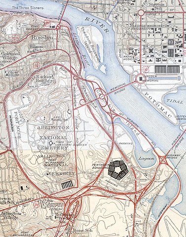
USGS topos covering the area around the Pentagon in Virginia, soon after the road network was built. Note that the Shirley Highway near the south edge of the map was added later, as it opened in 1943. |
|||||||||
| Font |
|
|||||||||
| Geotemporal data | ||||||||||
| Bounding box |
|
|||||||||
| Georeferencing | ||||||||||
Historial del fitxer
Cliqueu una data/hora per veure el fitxer tal com era aleshores.
| Data/hora | Miniatura | Dimensions | Usuari/a | Comentari | |
|---|---|---|---|---|---|
| actual | 21:31, 21 gen 2006 | | 1.020 × 1.300 (535 Ko) | SPUI~commonswiki | {{PD-USGov-USGS}} USGS topos covering the area around the Pentagon in Virginia, soon after the road network was built. Note that the Shirley Highway near the southwest edge of the map was added later, as it opened in 1943. *North half: [http://historical. |
Ús del fitxer
La pàgina següent utilitza aquest fitxer:
Ús global del fitxer
Utilització d'aquest fitxer en altres wikis:
- Utilització a ar.wikipedia.org
- Utilització a ast.wikipedia.org
- Utilització a da.wikipedia.org
- Utilització a de.wikipedia.org
- Utilització a el.wikipedia.org
- Utilització a en.wikipedia.org
- Utilització a et.wikipedia.org
- Utilització a ga.wikipedia.org
- Utilització a he.wikipedia.org
- Utilització a hr.wikipedia.org
- Utilització a hy.wikipedia.org
- Utilització a it.wikipedia.org
- Utilització a ja.wikipedia.org
- Utilització a kn.wikipedia.org
- Utilització a pl.wikipedia.org
- Utilització a pnb.wikipedia.org
- Utilització a tr.wikipedia.org
- Utilització a uz.wikipedia.org
- Utilització a www.wikidata.org