Fitxer:Persian Empire, 490 BC.png
Mida d'aquesta previsualització: 800 × 577 píxels. Altres resolucions: 320 × 231 píxels | 640 × 461 píxels | 946 × 682 píxels.
Fitxer original (946 × 682 píxels, mida del fitxer: 159 Ko, tipus MIME: image/png)
| Aquest fitxer i la informació mostrada a continuació provenen del dipòsit multimèdia lliure Wikimedia Commons. |
Resum
| Descripció |
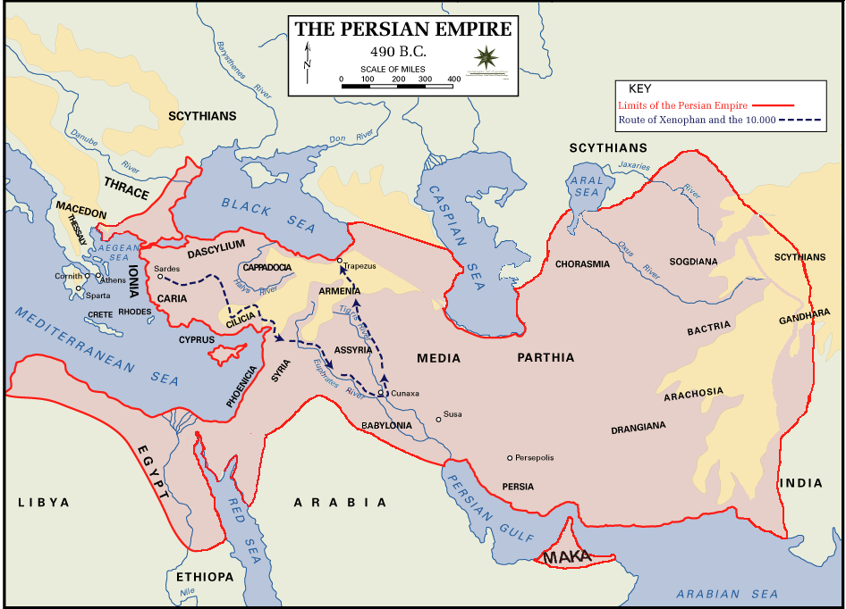
 English: Persian Empire, 490 BC, showing route of Cyrus the Younger, Xenophon and the 10.000.
Legends:
|
| Data | |
| Font | The Department of History - United States Military Academy |
| Autor | DHUSMA |
| Permís (Com reutilitzar aquest fitxer) |
In the public domain as original works of the United States federal government and/or military |
| Altres versions | For a version of this image altered to display better in Wikipedia articles (converted to PNG format, slightly cropped in File:Persian Empire, 490 BC.gif) y Italian version. |

|
Aquesta imatge (de tipus historical map) s'hauria de tornar a crear utilitzant gràfics vectorials com ara un fitxer SVG. Això té diversos avantatges; en trobareu més informació a Commons:Media for cleanup. Si ja disposeu d'una versió d'aquesta imatge en format SVG, us preguem que la pengeu; després, reemplaceu aquesta plantilla amb la plantilla {{Vector version available|nom nou de la imatge.svg}} en aquesta imatge.
|
Llicència
Aquesta obra és en el domini públic als Estats Units perquè és una obra del govern federal dels Estats Units sota els termes del Títol 17, Capítol 1, Secció 105 del Codi dels EUA. Vegeu drets d'autor.
Nota: Això només s'aplica a obres del Govern Federal i no a les dels estats individuals ni cap altra subdivisió administrativa. Aquesta plantilla tampoc no s'aplica a dissenys de segells de correus publicats pel Servei Postal dels Estats Units des de 1978 (vegeu 206.02(b) of Compendium II: Copyright Office Practices).
|
 | |
| Aquest fitxer està identificat com a lliure de restriccions conegudes sota la llei de drets d'autor, inclosos els drets veïns. | ||
Historial del fitxer
Cliqueu una data/hora per veure el fitxer tal com era aleshores.
| Data/hora | Miniatura | Dimensions | Usuari/a | Comentari | |
|---|---|---|---|---|---|
| actual | 04:11, 2 ago 2015 | | 946 × 682 (159 Ko) | History of Persia | Achaemenid Arabia. see wikipedia article about achaemenid arabia |
| 13:21, 11 abr 2013 |  | 942 × 684 (64 Ko) | HistoryofIran | {{subst:Upload marker added by en.wp UW}} {{Information |Description = {{en|Added another region named Maka, it was listen on the Behistun inscription as part of the Achaemenid Empire.}} |Source = https://en.wikipedia.org/wiki/File:Persian_Empire,_490_... | |
| 21:21, 10 abr 2013 |  | 942 × 684 (64 Ko) | HistoryofIran | Changed where Chorasmia was written, it was much closer to the Aral sea. | |
| 21:19, 10 abr 2013 |  | 942 × 684 (64 Ko) | HistoryofIran | Added a more accurate map. | |
| 00:55, 8 des 2012 |  | 942 × 684 (64 Ko) | Geagea | Colchis and Caucasian Iberia. Not Georgia. | |
| 18:24, 25 nov 2012 |  | 942 × 684 (97 Ko) | SilvioRusso | correction | |
| 02:49, 27 ago 2009 |  | 942 × 684 (64 Ko) | AnonMoos | Version of File:Persian Empire, 490 BC.gif altered to display better in Wikipedia articles (converted to PNG format, slightly cropped). == Summary == ; Description : Persian Empire, 490 BC ; Author/Source : [http://www.dean.usma.edu/history/ The Depa |
Ús del fitxer
La pàgina següent utilitza aquest fitxer:
Ús global del fitxer
Utilització d'aquest fitxer en altres wikis:
- Utilització a ast.wikipedia.org
- Utilització a bg.wikipedia.org
- Utilització a cs.wikipedia.org
- Utilització a da.wikipedia.org
- Utilització a el.wikipedia.org
- Utilització a en.wikipedia.org
- Utilització a eo.wikipedia.org
- Utilització a eu.wikipedia.org
- Utilització a fa.wikipedia.org
- Utilització a fr.wikipedia.org
- Utilització a fr.wikisource.org
- Utilització a fy.wikipedia.org
- Utilització a hr.wikipedia.org
- Utilització a hu.wikipedia.org
- Utilització a hy.wikipedia.org
- Utilització a id.wikipedia.org
- Utilització a it.wikipedia.org
- Utilització a ko.wikipedia.org
- Utilització a ku.wikipedia.org
- Utilització a la.wikipedia.org
- Utilització a nl.wikipedia.org
- Utilització a no.wikipedia.org
- Utilització a pnb.wikipedia.org
- Utilització a pnt.wikipedia.org
- Utilització a ro.wikipedia.org
- Utilització a ru.wikipedia.org
- Utilització a sh.wikipedia.org
- Utilització a sr.wikipedia.org
Vegeu més usos globals d'aquest fitxer.