Fitxer:Ragusa.png
No hi ha cap versió amb una resolució més gran.
Ragusa.png (675 × 354 píxels, mida del fitxer: 128 Ko, tipus MIME: image/png)
| Aquest fitxer i la informació mostrada a continuació provenen del dipòsit multimèdia lliure Wikimedia Commons. |
Resum
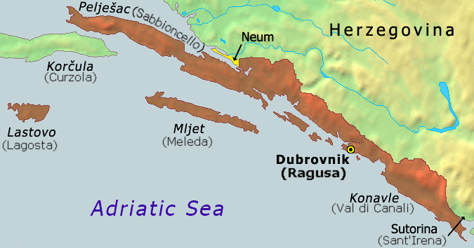
| Descripció |
Hrvatski: Karta Dubrovačke republike iz 1808
English: Map of the Republic of Ragusa as of 1808 |
||
| Data | |||
| Font | Demis Map Server (http://www2.demis.nl/mapserver/mapper.asp) data with additional annotations and modifications by self. | ||
| Autor | ChrisO | ||
| Altres versions |
Derivative works of this file: Ragusa-IT.png
|


|
Aquesta imatge (de tipus historical map) s'hauria de tornar a crear utilitzant gràfics vectorials com ara un fitxer SVG. Això té diversos avantatges; en trobareu més informació a Commons:Media for cleanup. Si ja disposeu d'una versió d'aquesta imatge en format SVG, us preguem que la pengeu; després, reemplaceu aquesta plantilla amb la plantilla {{Vector version available|nom nou de la imatge.svg}} en aquesta imatge.
|
Historial del fitxer
Cliqueu una data/hora per veure el fitxer tal com era aleshores.
| Data/hora | Miniatura | Dimensions | Usuari/a | Comentari | |
|---|---|---|---|---|---|
| actual | 09:51, 21 oct 2020 | | 675 × 354 (128 Ko) | Claude Zygiel | Ragusan / Venetian names also (official until 1918) |
| 21:49, 6 feb 2020 |  | 675 × 354 (114 Ko) | Ceha | Klek was part of Dubrovnik Republic. Tip of the peninsula is in Croatia, while the rest is in BiH. The same goes for the small island of Lastavica, which is today in Montenegro... https://www.google.com/maps/place/Mamula/@42.3952695,18.4181714,11z/data=!4m5!3m4!1s0x134c24e629d0b6ed:0x1d78b87fc20846b1!8m2!3d42.3954043!4d18.5585609 | |
| 23:15, 8 set 2010 |  | 675 × 354 (65 Ko) | DIREKTOR | fix | |
| 19:02, 25 nov 2006 |  | 675 × 354 (53 Ko) | Tieum512 | {{Information |Description=Map of the Republic of Ragusa as of 1808 Based on Demis Web Map Server output |Source=http://en.wikipedia.org/wiki/Image:Ragusa.png |Date= |Author=User:ChrisO |Permission=GFDL |other_versions= }} |
Ús del fitxer
La pàgina següent utilitza aquest fitxer:
Ús global del fitxer
Utilització d'aquest fitxer en altres wikis:
- Utilització a an.wikipedia.org
- Utilització a ar.wikipedia.org
- Utilització a ast.wikipedia.org
- Utilització a azb.wikipedia.org
- Utilització a az.wikipedia.org
- Utilització a be-tarask.wikipedia.org
- Utilització a be.wikipedia.org
- Utilització a bg.wikipedia.org
- Utilització a br.wikipedia.org
- Utilització a bs.wikipedia.org
- Utilització a cs.wikipedia.org
- Utilització a da.wikipedia.org
- Utilització a de.wikipedia.org
- Utilització a el.wikipedia.org
- Utilització a en.wikipedia.org
- Utilització a eo.wikipedia.org
- Utilització a es.wikipedia.org
- Utilització a et.wikipedia.org
- Utilització a eu.wikipedia.org
- Utilització a fa.wikipedia.org
- Utilització a fi.wikipedia.org
- Utilització a fr.wikipedia.org
- Utilització a fy.wikipedia.org
- Utilització a gl.wikipedia.org
- Utilització a he.wikipedia.org
- Utilització a hu.wikipedia.org
- Utilització a ia.wikipedia.org
- Utilització a id.wikipedia.org
- Utilització a ie.wikipedia.org
- Utilització a it.wikipedia.org
- Utilització a ja.wikipedia.org
- Utilització a ko.wikipedia.org
- Utilització a li.wikipedia.org
- Utilització a mk.wikipedia.org
- Utilització a ms.wikipedia.org
- Utilització a mt.wikipedia.org
- Utilització a nl.wikipedia.org
Vegeu més usos globals d'aquest fitxer.