Fitxer:River Forth course 3.png

Mida d'aquesta previsualització: 800 × 322 píxels. Altres resolucions: 320 × 129 píxels | 640 × 258 píxels | 1.024 × 413 píxels | 2.000 × 806 píxels.
Fitxer original (2.000 × 806 píxels, mida del fitxer: 981 Ko, tipus MIME: image/png)
| Aquest fitxer i la informació mostrada a continuació provenen del dipòsit multimèdia lliure Wikimedia Commons. |
Resum
| Descripció |
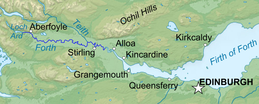
English: Topographic map in English of Scotland This is a lighter raster JPG format version of Image:Scotland_topographic_map-en.svg which should be used in the article pages, the vector graphics version purpose being for modification and / or translation. Français : Carte topographique en anglais de l'Écosse. *UTM projection ; WGS84 datum ; shaded relief (composite image of N-W, W and N lightning positions) ;Ceci est une version bitmap au format JPG et de poids de fichier plus léger de Image:Scotland_topographic_map-fr.svg qui devrait être utilisée dans les pages d'articles, la version vectorisée SVG étant destinée à faciliter les modifications et / ou traductions. *Scales: **Topography and shore/lakes limits: 1:872,000 (accuracy: 218 m) until 60.38° and 1:3,800,000 (accuracy: 950 m) North of 60.38° ; ** Bathymetry: 1:7,588,000 (accuracy: 1,897 m) |
| Data | (UTC) |
| Font |
This file was derived from: Scotland topographic map-en.jpg:  |
| Autor |
|
| Això és una imatge retocada, cosa que vol dir que ha estat alterada digitalment de la seva versió original. Modificacions: Isolated the river forth area. L'original es pot veure a: Scotland topographic map-en.jpg:
|
Llicència
Jo, el titular dels drets d'autor d'aquest treball, el public sota les següents llicències:
Aquest fitxer està subjecte a la llicència Creative Commons Reconeixement i Compartir Igual 3.0 No adaptada, 2.5 Genèrica, 2.0 Genèrica i 1.0 Genèrica.
- Sou lliure de:
- compartir – copiar, distribuir i comunicar públicament l'obra
- adaptar – fer-ne obres derivades
- Amb les condicions següents:
- reconeixement – Heu de donar la informació adequada sobre l'autor, proporcionar un enllaç a la llicència i indicar si s'han realitzat canvis. Podeu fer-ho amb qualsevol mitjà raonable, però de cap manera no suggereixi que l'autor us dóna suport o aprova l'ús que en feu.
- compartir igual – Si modifiqueu, transformeu, o generareu amb el material, haureu de distribuir les vostres contribucions sota una llicència similar o una de compatible com l'original

|
S'autoritza la còpia, la distribució i la modificació d'aquest document sota els termes de la llicència de documentació lliure GNU versió 1.2 o qualsevol altra versió posterior que publiqui la Free Software Foundation; sense seccions invariants, ni textos de portada, ni textos de contraportada. S'inclou una còpia d'aquesta llicència en la secció titulada GNU Free Documentation License. |
Podeu seleccionar la llicència que vulgueu.
Registre original de càrregues
This image is a derivative work of the following images:
- File:Scotland_topographic_map-en.jpg licensed with Cc-by-sa-3.0,2.5,2.0,1.0, GFDL
- 2010-07-17T21:41:29Z Sting 2400x3450 (2398211 Bytes) Color profile
- 2008-09-24T23:35:01Z Sting 2400x3450 (2082807 Bytes) Completely new background : raster topography and using ETOPO1 data for bathymetry ; new standard colors
- 2007-12-14T01:02:41Z Sting 2400x3450 (2224139 Bytes) Additional name
- 2007-12-12T20:55:32Z Sting 2400x3450 (2220337 Bytes) Correction in key
- 2007-12-12T16:18:25Z Sting 2400x3450 (2218854 Bytes) {{Location|57|00|00|N|04|00|00|W|scale:4000000}} {{Information |Description=Topographic map in English of [[:en:Scotland|Scotland]]This is a lighter raster JPG format version of [[:Image:Scotland_topographic_map-en.svg]] whi
Uploaded with derivativeFX
Historial del fitxer
Cliqueu una data/hora per veure el fitxer tal com era aleshores.
| Data/hora | Miniatura | Dimensions | Usuari/a | Comentari | |
|---|---|---|---|---|---|
| actual | 00:04, 23 gen 2013 | 2.000 × 806 (981 Ko) | VanguardScot | Added loch ard, highlighted the actual river forth | |
| 23:57, 22 gen 2013 | 2.988 × 1.204 (991 Ko) | VanguardScot | added grangemouth | ||
| 00:27, 18 gen 2013 | 715 × 263 (314 Ko) | VanguardScot | == {{int:filedesc}} == {{Information |Description={{en|Topographic map in English of Scotland<br/>This is a lighter raster JPG format version of Image:Scotland_topographic_map-en.svg which should be used in the article pages, the ... |
Ús del fitxer
La pàgina següent utilitza aquest fitxer:
Ús global del fitxer
Utilització d'aquest fitxer en altres wikis:
- Utilització a cs.wikipedia.org
- Utilització a en.wikipedia.org
- Utilització a et.wikipedia.org
- Utilització a fa.wikipedia.org
- Utilització a fi.wikipedia.org
- Utilització a fr.wikipedia.org
- Utilització a he.wikipedia.org
- Utilització a is.wikipedia.org
- Utilització a it.wikipedia.org
- Utilització a ja.wikipedia.org
- Utilització a no.wikipedia.org
- Utilització a sh.wikipedia.org
- Utilització a sr.wikipedia.org
- Utilització a uk.wikipedia.org