Fitxer:Russia ethnic.JPG
Fitxer original (1.017 × 1.253 píxels, mida del fitxer: 501 Ko, tipus MIME: image/jpeg)
| Aquest fitxer i la informació mostrada a continuació provenen del dipòsit multimèdia lliure Wikimedia Commons. |
| Descripció |
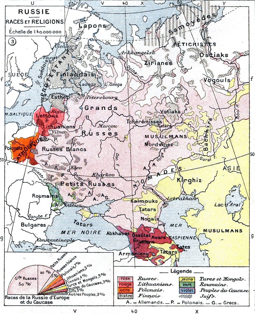
English: Ethnic map of the European part of the Russian Empire
Deutsch: Ethnische Karte des europäischen Russland vor dem Ersten Weltkrieg |
||||
| Data | |||||
| Font | Histoire Et Géographie - Atlas Général Vidal-Lablache, Librairie Armand Colin, Paris, 1898 | ||||
| Autor | own scan | ||||
| Permís (Com reutilitzar aquest fitxer) |
|
||||

|
Aquesta imatge (de tipus old map) s'hauria de tornar a crear utilitzant gràfics vectorials com ara un fitxer SVG. Això té diversos avantatges; en trobareu més informació a Commons:Media for cleanup. Si ja disposeu d'una versió d'aquesta imatge en format SVG, us preguem que la pengeu; després, reemplaceu aquesta plantilla amb la plantilla {{Vector version available|nom nou de la imatge.svg}} en aquesta imatge.
|


Historial del fitxer
Cliqueu una data/hora per veure el fitxer tal com era aleshores.
| Data/hora | Miniatura | Dimensions | Usuari/a | Comentari | |
|---|---|---|---|---|---|
| actual | 22:00, 10 maig 2011 | | 1.017 × 1.253 (501 Ko) | Alex:D | Revert. The original author agreed with this version, stop messing around... |
| 03:24, 5 març 2011 |  | 1.017 × 1.253 (1,34 Mo) | Vizu | Reverted to version as of 13:39, 13 November 2009 Original colours | |
| 17:20, 15 nov 2009 |  | 1.017 × 1.253 (501 Ko) | Alex:D | Back to improved vers. | |
| 15:39, 13 nov 2009 |  | 1.017 × 1.253 (1,34 Mo) | Cameron kennedy | Reverted to version as of 15:12, 3 June 2009 | |
| 18:12, 6 nov 2009 |  | 1.017 × 1.253 (501 Ko) | Alex:D | whitened | |
| 17:12, 3 juny 2009 |  | 1.017 × 1.253 (1,34 Mo) | Olahus | {{Information |Description={{en|Ethnic map of the European part of the Russian Empire}} |Source=Histoire Et Géographie - Atlas Général Vidal-Lablache, Librairie Armand Colin, Paris, 1898 |Date=1898 |Author=own scan |Permission={{pd-old}} |other_version |
Ús del fitxer
Ús global del fitxer
Utilització d'aquest fitxer en altres wikis:
- Utilització a af.wikipedia.org
- Utilització a ar.wikipedia.org
- Utilització a azb.wikipedia.org
- Utilització a be-tarask.wikipedia.org
- Utilització a be.wikipedia.org
- Utilització a bg.wikipedia.org
- Utilització a da.wikipedia.org
- Utilització a de.wikipedia.org
- Utilització a el.wikipedia.org
- Utilització a en.wikipedia.org
- Utilització a eo.wikipedia.org
- Utilització a fr.wikipedia.org
- Utilització a ga.wikipedia.org
- Utilització a hr.wikipedia.org
- Utilització a ht.wikipedia.org
- Utilització a hy.wikipedia.org
- Utilització a hyw.wikipedia.org
- Utilització a it.wikipedia.org
- Utilització a ja.wikipedia.org
- Utilització a ka.wikipedia.org
- Utilització a lt.wikipedia.org
- Utilització a mk.wikipedia.org
- Utilització a ml.wikipedia.org
- Utilització a mn.wikipedia.org
- Utilització a no.wikipedia.org
- Utilització a pl.wikipedia.org
- Utilització a pt.wikipedia.org
- Utilització a ro.wikipedia.org
Vegeu més usos globals d'aquest fitxer.