Fitxer:Saint Vincent OnEarth WMS.png

Mida d'aquesta previsualització: 600 × 600 píxels. Altres resolucions: 240 × 240 píxels | 480 × 480 píxels | 768 × 768 píxels | 1.215 × 1.215 píxels.
Fitxer original (1.215 × 1.215 píxels, mida del fitxer: 2,22 Mo, tipus MIME: image/png)
| Aquest fitxer i la informació mostrada a continuació provenen del dipòsit multimèdia lliure Wikimedia Commons. |
| Descripció |
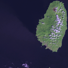
Satellite image of Saint Vincent Screenshot from NASA World Wind, OnEarth WMS global mosaic pseudocolor layer. |
| Data | (UTC) |
| Font | |
| Autor |
|
| Això és una imatge retocada, cosa que vol dir que ha estat alterada digitalment de la seva versió original. Modificacions: resizing for focus. L'original es pot veure a: Saint Vincent and the Grenadines OnEarth WMS.png:
|
| This image is in the public domain because it is a screenshot from NASA’s globe software World Wind using a public domain layer, such as Blue Marble, MODIS, Landsat, SRTM, USGS or GLOBE.
|
 |
Registre original de càrregues
This image is a derivative work of the following images:
- File:Saint_Vincent_and_the_Grenadines_OnEarth_WMS.png licensed with PD-WorldWind
- 2006-04-29T20:36:20Z Hautala 1215x2869 (4062405 Bytes) {{PD-WorldWind}} Satellite image of Saint Vincent and the Grenadines. Screenshot from NASA World Wind, OnEarth WMS layer. [[Category:Satellite images of countries]]
Uploaded with derivativeFX
Historial del fitxer
Cliqueu una data/hora per veure el fitxer tal com era aleshores.
| Data/hora | Miniatura | Dimensions | Usuari/a | Comentari | |
|---|---|---|---|---|---|
| actual | 18:47, 19 gen 2009 | | 1.215 × 1.215 (2,22 Mo) | Xfigpower | {{Information |Description=Satellite image of Saint Vincent Screenshot from NASA World Wind, OnEarth WMS global mosaic pseudocolor layer. |Source=*File:Saint_Vincent_and_the_Grenadines_OnEarth_WMS.png |Date=2009-01-19 16:46 (UTC) |Author=*derivative |
Ús del fitxer
La pàgina següent utilitza aquest fitxer:
Ús global del fitxer
Utilització d'aquest fitxer en altres wikis:
- Utilització a ar.wikipedia.org
- Utilització a az.wikipedia.org
- Utilització a be.wikipedia.org
- Utilització a br.wikipedia.org
- Utilització a da.wikipedia.org
- Utilització a de.wikivoyage.org
- Utilització a es.wikipedia.org
- Utilització a fi.wikipedia.org
- Utilització a fi.wiktionary.org
- Utilització a frr.wikipedia.org
- Utilització a fr.wikipedia.org
- Utilització a gl.wikipedia.org
- Utilització a he.wikipedia.org
- Utilització a ja.wikipedia.org
- Utilització a lb.wikipedia.org
- Utilització a lt.wikipedia.org
- Utilització a pap.wikipedia.org
- Utilització a tr.wikipedia.org
- Utilització a ur.wikipedia.org
- Utilització a www.wikidata.org