Fitxer:SatavahanaMap.jpg

Mida d'aquesta previsualització: 467 × 599 píxels. Altres resolucions: 187 × 240 píxels | 374 × 480 píxels | 599 × 768 píxels | 1.123 × 1.440 píxels.
Fitxer original (1.123 × 1.440 píxels, mida del fitxer: 327 Ko, tipus MIME: image/jpeg)
| Aquest fitxer i la informació mostrada a continuació provenen del dipòsit multimèdia lliure Wikimedia Commons. |

|
This map has been uploaded by Electionworld from en.wikipedia.org to enable the |

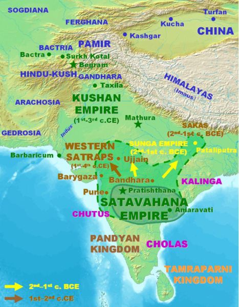
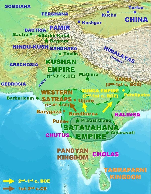
Approximate extent of the Satavahana Empire.
Personal map, 2005. Released in the Public Domain.
| S'ha alliberat aquesta obra al domini públic pel seu autor PHG. Això s'aplica a tot el món. En alguns països això pot no ser legalment possible, en tal cas: |
Historial del fitxer
Cliqueu una data/hora per veure el fitxer tal com era aleshores.
| Data/hora | Miniatura | Dimensions | Usuari/a | Comentari | |
|---|---|---|---|---|---|
| actual | 16:09, 18 març 2007 | | 1.123 × 1.440 (327 Ko) | World Imaging | Better map, personal creation. |
| 01:21, 14 des 2006 |  | 395 × 432 (29 Ko) | Electionworld | {{ew|en|PHG}} {{POV-map}} Approximate extent of the Satavahana Empire. Personal map, 2005. Released in the Public Domain. {{pd}} |
Ús del fitxer
La pàgina següent utilitza aquest fitxer:
Ús global del fitxer
Utilització d'aquest fitxer en altres wikis:
- Utilització a ba.wikipedia.org
- Utilització a bn.wikipedia.org
- Utilització a cs.wikipedia.org
- Utilització a cv.wikipedia.org
- Utilització a de.wikipedia.org
- Utilització a en.wikipedia.org
- Utilització a es.wikipedia.org
- Utilització a eu.wikipedia.org
- Utilització a fa.wikipedia.org
- Utilització a fi.wikipedia.org
- Utilització a fr.wikipedia.org
- Utilització a hi.wikipedia.org
- Utilització a hy.wikipedia.org
- Utilització a id.wikipedia.org
- Utilització a id.wikibooks.org
- Utilització a it.wikipedia.org
- Utilització a kn.wikipedia.org
- Utilització a ko.wikipedia.org
- Utilització a lt.wikipedia.org
- Utilització a mr.wikipedia.org
- Utilització a nl.wikipedia.org
- Utilització a pnb.wikipedia.org
- Utilització a ru.wikipedia.org
- Utilització a sa.wikipedia.org
- Utilització a sh.wikipedia.org
- Utilització a si.wikipedia.org
- Utilització a sq.wikipedia.org
- Utilització a sr.wikipedia.org
- Utilització a te.wikipedia.org
- Utilització a th.wikipedia.org
- Utilització a tl.wikipedia.org
- Utilització a tt.wikipedia.org
- Utilització a uk.wikipedia.org
- Utilització a ur.wikipedia.org
Vegeu més usos globals d'aquest fitxer.