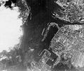
Fitxer:Scharnhorst-22.jpg

Mida d'aquesta previsualització: 704 × 599 píxels. Altres resolucions: 282 × 240 píxels | 564 × 480 píxels | 740 × 630 píxels.
Fitxer original (740 × 630 píxels, mida del fitxer: 324 Ko, tipus MIME: image/jpeg)
Historial del fitxer
Cliqueu una data/hora per veure el fitxer tal com era aleshores.
| Data/hora | Miniatura | Dimensions | Usuari/a | Comentari | |
|---|---|---|---|---|---|
| actual | 14:43, 17 set 2005 |  | 740 × 630 (324 Ko) | Igiveup | Aerial reconnaissance photograph, probably taken by the British Royal Air Force circa February-June 1942. The arrow in the lower center marks the position of the battleship Scharnhorst, which was then under repair at the Kiel navy yard for damage received |
Ús del fitxer
La pàgina següent utilitza aquest fitxer:
Ús global del fitxer
Utilització d'aquest fitxer en altres wikis:
- Utilització a en.wikipedia.org
- Utilització a es.wikipedia.org
- Utilització a hu.wikipedia.org
- Utilització a it.wikipedia.org
- Utilització a ta.wikipedia.org
- Utilització a uk.wikipedia.org
- Utilització a zh.wikipedia.org

