Fitxer:Serbia02.png

Mida d'aquesta previsualització: 457 × 599 píxels. Altres resolucions: 183 × 240 píxels | 366 × 480 píxels | 724 × 949 píxels.
Fitxer original (724 × 949 píxels, mida del fitxer: 73 Ko, tipus MIME: image/png)
| Aquest fitxer i la informació mostrada a continuació provenen del dipòsit multimèdia lliure Wikimedia Commons. |
Resum
| Descripció |
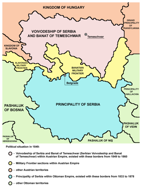
English: Two autonomous historical territories named Serbia: 1. Principality of Serbia within Ottoman Empire (1833-1878), and 2. Voivodeship of Serbia and Banat of Temeschwar within Austrian Empire (1849-1860)
Српски / srpski: Две аутономне историјске територије са називом Србија: 1. Кнежевина Србија у оквиру Отоманског царства (1833-1878) и 2. Војводство Србија и Тамишки Банат у оквиру Аустријског царства (1849-1860) |
||
| Data | |||
| Font |
|
||
| Autor | Self-made map by PANONIAN | ||
| Permís (Com reutilitzar aquest fitxer) |
|
||
| Altres versions |
  |

References
Published references:
- The Times History of Europe, Times Books, 2002.
- Sima M. Ćirković, Srbi među evropskim narodima, Beograd, 2004.
- Dr Tomislav Bogavac, Nestajanje Srba, Niš, 1994.
- Dragomir Jankov, Vojvodina - propadanje jednog regiona, Novi Sad, 2004.
- Istorijski atlas, Zavod za udžbenike i nastavna sredstva - Zavod za kartografiju "Geokarta", Beograd, 1999.
- Školski istorijski atlas, Zavod za izdavanje udžbenika Socijalističke Republike Srbije, Beograd, 1970.
- Peter Rokai - Zoltan Đere - Tibor Pal - Aleksandar Kasaš, Istorija Mađara, Beograd, 2002.
- Lazo M. Kostić, Srpska Vojvodina i njene manjine, Novi Sad, 1999.
- Drago Njegovan, Prisajedinjenje Vojvodine Srbiji, Novi Sad, 2004.
- Čedomir Popov - Jelena Popov, Autonomija Vojvodine - srpsko pitanje, Sremski Karlovci, 2000.
- Dr Dušan J. Popović, Srbi u Vojvodini, knjiga 3, Novi Sad, 1990.
- J. H. Šviker, Politička istorija Srba u Ugarskoj, Novi Sad - Beograd, 1998.
- Sigfrid Kaper, Srpski pokret u južnoj Ugarskoj 1848-1849, Beograd - Valjevo, 1996.
- Dimitrije Boarov, Politička istorija Vojvodine, Novi Sad, 2001.
- Dejan Mikavica, Srpska Vojvodina u Habsburškoj monarhiji 1690-1920, Novi Sad, 2005.
- Dr Milenko Palić, Srbi u Mađarskoj - Ugarskoj do 1918, Novi Sad, 1995.
- Drago Njegovan, Srpska Vojvodina, Enciklopedija Novog Sada, knjiga 26, Novi Sad, 2005.
- Istorija Vojvodine, Enciklopedija Novog Sada, sveska 5, Novi Sad, 1996.
- Vladimir Ćorović, Ilustrovana istorija Srba, knjiga peta, Beograd, 2006.
- Vasilije Krestić, Iz prošlosti Srema, Bačke i Banata, Beograd, 2003.
- Slavko Gavrilović, Srbi u Habsburškoj Monarhiji (1792-1849), Novi Sad, 1994.
- Milan Tutorov, Banatska rapsodija, Novi Sad, 2001.
- Jovan M. Pejin, Iz prošlosti Kikinde, Kikinda, 2000.
- Rodoljub Malenčić, Miletić, Novi Sad, 1996.
- Čedomir Popov - Slavko Gavrilović, Evropska revolucija i srpski pokret 1848-1849, Beograd - Novi Sad, 1997.
Internet references:
- Bahovo doba - Vojvodstvo Srbija i Tamiški Banat (in Serbian)
- Titles of Habsburg emperors
- Map
- Map
- Map
- Map
- Map
Historial del fitxer
Cliqueu una data/hora per veure el fitxer tal com era aleshores.
| Data/hora | Miniatura | Dimensions | Usuari/a | Comentari | |
|---|---|---|---|---|---|
| actual | 16:17, 8 oct 2013 | | 724 × 949 (73 Ko) | PANONIAN | aesthetics |
| 12:20, 24 des 2009 |  | 717 × 944 (73 Ko) | PANONIAN | aesthetics | |
| 20:50, 1 juny 2009 |  | 717 × 944 (73 Ko) | PANONIAN | ||
| 00:19, 14 feb 2008 |  | 522 × 557 (28 Ko) | Imbris~commonswiki | The image must be free of POV. The image I'am proposing is using different colours for the Principality of Serbia and Serb Voivodship and Tamiš Banate. | |
| 13:58, 1 maig 2007 |  | 522 × 613 (70 Ko) | Tene~commonswiki | Optimised (0) | |
| 23:40, 21 des 2006 |  | 522 × 613 (87 Ko) | Electionworld | {{ew|en|PANONIAN}} Self-made map by PANONIAN {{PD-user|PANONIAN}} Category:Maps of Serbia |
Ús del fitxer
Les 2 pàgines següents utilitzen aquest fitxer:
Ús global del fitxer
Utilització d'aquest fitxer en altres wikis:
- Utilització a ast.wikipedia.org
- Utilització a cs.wikipedia.org
- Utilització a el.wikipedia.org
- Utilització a en.wikipedia.org
- Utilització a es.wikipedia.org
- Utilització a et.wikipedia.org
- Utilització a fr.wikipedia.org
- Utilització a gl.wikipedia.org
- Utilització a he.wikipedia.org
- Utilització a ja.wikipedia.org
- Utilització a ka.wikipedia.org
- Utilització a lt.wikipedia.org
- Utilització a nl.wikipedia.org
- Utilització a sq.wikipedia.org
- Utilització a sv.wikipedia.org
- Utilització a th.wikipedia.org
- Utilització a tr.wikipedia.org
- Utilització a uk.wikipedia.org
- Utilització a vi.wikipedia.org
- Utilització a zh.wikipedia.org