Fitxer:Seven second summits map-fr.svg

Mida d'aquesta previsualització PNG del fitxer SVG: 800 × 406 píxels. Altres resolucions: 320 × 163 píxels | 640 × 325 píxels | 1.024 × 520 píxels | 1.280 × 650 píxels | 2.560 × 1.300 píxels | 1.636 × 831 píxels.
Fitxer original (fitxer SVG, nominalment 1.636 × 831 píxels, mida del fitxer: 4,11 Mo)
| Aquest fitxer i la informació mostrada a continuació provenen del dipòsit multimèdia lliure Wikimedia Commons. |
Resum
| Descripció |
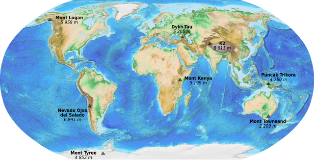
English: Map of the Seven Second Summits. French version.
Français : Carte des Sept seconds sommets (secondes plus hautes montagnes de chaque continent). |
||
| Data | (UTC) | ||
| Font |
|
||
| Autor | Sémhur (talk) | ||
| Altres versions | |||
| Reconeixement (required by the license) | © Sémhur / Wikimedia Commons / | ||
| SVG | W3C-validity not checked. Aquesta imatge vectorial ha estat creada amb Inkscape .
|
||
| Graphic Lab |

Llicència
This image is in the public domain because it contains materials that originally came from the U.S. National Oceanic and Atmospheric Administration, taken or made as part of an employee's official duties.
|
Historial del fitxer
Cliqueu una data/hora per veure el fitxer tal com era aleshores.
| Data/hora | Miniatura | Dimensions | Usuari/a | Comentari | |
|---|---|---|---|---|---|
| actual | 23:28, 22 oct 2010 | | 1.636 × 831 (4,11 Mo) | Sémhur | == {{int:filedesc}} == {{Information |Description={{en|1=Map of the Seven Second Summits. French version.}} {{fr|1=Carte des Sept seconds sommets (secondes plus hautes montagnes de chaque continent |
Ús del fitxer
La pàgina següent utilitza aquest fitxer:
Ús global del fitxer
Utilització d'aquest fitxer en altres wikis:
- Utilització a en.wikipedia.org
- Utilització a es.wikipedia.org
- Utilització a fa.wikipedia.org
- Utilització a fr.wikipedia.org
- Utilització a he.wikipedia.org
- Utilització a ja.wikipedia.org
- Utilització a nn.wikipedia.org
- Utilització a pt.wikipedia.org
- Utilització a sl.wikipedia.org
- Utilització a uk.wikipedia.org
- Utilització a www.wikidata.org