Fitxer:Sud Italia nel 1112.jpg
Mida d'aquesta previsualització: 529 × 600 píxels. Altres resolucions: 212 × 240 píxels | 423 × 480 píxels | 712 × 807 píxels.
Fitxer original (712 × 807 píxels, mida del fitxer: 94 Ko, tipus MIME: image/jpeg)
| Aquest fitxer i la informació mostrada a continuació provenen del dipòsit multimèdia lliure Wikimedia Commons. |
Resum
| Descripció |
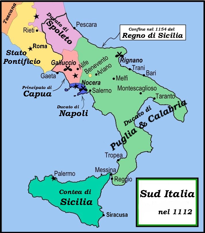
English: This is a political map of southern Italy in 1112 AD/CE, the date when Roger II of Sicily reached his age of majority, also showing the border of the Kingdom of Sicily in 1154, on his death.
"The rarity of surviving records makes it impossible to draw a map of comital [counts'] responsibiities in southern Italy at the beginning of the twelth century." Matthew, p. 23. As noted by Matthew, the political situation in southern Italy is much more complex than this map shows. There were numerous counts and semi-independent cities throughout the region. Moreover, the near-constant rebellions and conquests continually re-arranged the map. |
| Data | |
| Font | File:Southern Italy 1112.svg MapMaster |
| Autor | MapMaster |
| Altres versions |
[]
|


References
- Bjorklund, Oddvar; Holmboe, Haakon; Rohr, Anders (1970) Historical Atlas of the World, Barnes & Noble, NY, SBN: 389-00253-4.
- Houben, Hubert (translated by Graham A. Loud and Diane Milburn), (2002) Roger II of Sicily: Ruler between East and West, Cambridge University Press.
- Konstam, Angus (2000) Atlas of Medieval Europe, Checkmark Books, New York.
- Matthew, Donald (1992) The Norman Kingdom of Sicily Cambridge Medieval Textbooks.
Llicència
Jo, el titular dels drets d'autor d'aquest treball, el public sota les següents llicències:

|
S'autoritza la còpia, la distribució i la modificació d'aquest document sota els termes de la llicència de documentació lliure GNU versió 1.2 o qualsevol altra versió posterior que publiqui la Free Software Foundation; sense seccions invariants, ni textos de portada, ni textos de contraportada. S'inclou una còpia d'aquesta llicència en la secció titulada GNU Free Documentation License. |
This file is licensed under the Creative Commons Attribution-Share Alike 4.0 International, 3.0 Unported, 2.5 Generic, 2.0 Generic and 1.0 Generic license.
- Sou lliure de:
- compartir – copiar, distribuir i comunicar públicament l'obra
- adaptar – fer-ne obres derivades
- Amb les condicions següents:
- reconeixement – Heu de donar la informació adequada sobre l'autor, proporcionar un enllaç a la llicència i indicar si s'han realitzat canvis. Podeu fer-ho amb qualsevol mitjà raonable, però de cap manera no suggereixi que l'autor us dóna suport o aprova l'ús que en feu.
- compartir igual – Si modifiqueu, transformeu, o generareu amb el material, haureu de distribuir les vostres contribucions sota una llicència similar o una de compatible com l'original
Podeu seleccionar la llicència que vulgueu.
Historial del fitxer
Cliqueu una data/hora per veure el fitxer tal com era aleshores.
| Data/hora | Miniatura | Dimensions | Usuari/a | Comentari | |
|---|---|---|---|---|---|
| actual | 20:59, 1 març 2008 | | 712 × 807 (94 Ko) | Franco aq | {{Information |Description= |Source=Wikimedia Commons |Date=01 03 2008 |Author=User:MapMaster |other_versions=Image:Southern Italy 1112.svg }} |
Ús del fitxer
Les 2 pàgines següents utilitzen aquest fitxer:
Ús global del fitxer
Utilització d'aquest fitxer en altres wikis:
- Utilització a arz.wikipedia.org
- Utilització a bg.wikipedia.org
- Utilització a br.wikipedia.org
- Utilització a co.wikipedia.org
- Utilització a de.wikipedia.org
- Utilització a el.wikipedia.org
- Utilització a fr.wikipedia.org
- Utilització a gl.wikipedia.org
- Utilització a hu.wikipedia.org
- Utilització a it.wikipedia.org
- Napoli
- Rainulfo di Alife
- Sovrani dei regni di Sicilia e di Napoli
- Antichi Stati italiani
- Montescaglioso
- Ducato di Napoli
- Regno di Sicilia
- Terra di Lavoro
- Storia di Napoli
- Principato di Capua
- Roberto II di Capua
- Battaglia di Nocera
- Alfonso d'Altavilla
- Suddivisione amministrativa del Regno di Napoli
- Contea di Sicilia
- Ducato di Puglia e Calabria
- Storia della Campania
- Cortimpiano
- Resti e reperti archeologici della metropolitana di Napoli
- Utente:Memnone di Rodi/Sandbox/Napoli
- Contea di Tricarico
- Sovrani italiani
- Giordano II di Capua
- Cronologia della storia di Teramo
- Utilització a lt.wikipedia.org
- Utilització a nl.wikipedia.org
- Utilització a pl.wikipedia.org
- Utilització a uk.wikipedia.org
- Utilització a vi.wikipedia.org