Fitxer:Syria 2004 CIA map-2010-07-09.JPG
Mida d'aquesta previsualització: 800 × 574 píxels. Altres resolucions: 320 × 229 píxels | 640 × 459 píxels | 1.004 × 720 píxels.
Fitxer original (1.004 × 720 píxels, mida del fitxer: 127 Ko, tipus MIME: image/jpeg)
| Aquest fitxer i la informació mostrada a continuació provenen del dipòsit multimèdia lliure Wikimedia Commons. |
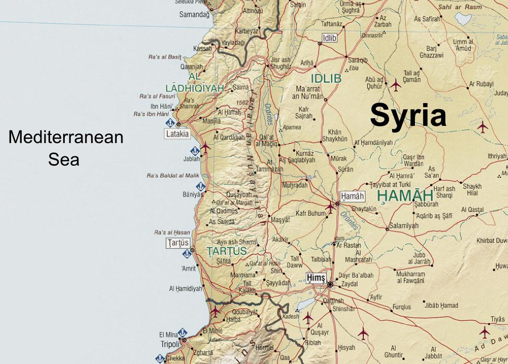
| Descripció | Syria. United States. Central Intelligence Agency. CREATED/PUBLISHED [Washington, D.C. : Central Intelligence Agency, 2004] NOTES "803011 (C00612) 1-04." Scale 1:1,300,000 ; Lambert conformal conic proj., standard parallels 32010'N and 38020'N (E 350--E 420/N 370--N 320). SUBJECTS Syria--Maps. Syria. MEDIUM 1 map : col. ; 66 x 66 cm. CALL NUMBER G7460 2004 .U5 REPOSITORY Library of Congress Geography and Map Division Washington, D.C. 20540-4650 USA DIGITAL ID g7460 ct001190 http://hdl.loc.gov/loc.gmd/g7460.ct001190 |
| Data | (UTC) |
| Font | |
| Autor |
|
| Això és una imatge retocada, cosa que vol dir que ha estat alterada digitalment de la seva versió original. Modificacions: Zoomed in at the An-Nusayriyah Mountains, removed the typing "Cape Apostolos Andreas" at eastern Cyprus, removed the Golan Heights zoomed map, replaced the name "Mediterranean Sea", added the name "Syria". L'original es pot veure a: Syria 2004 CIA map.jpg:
|
| This image is a work of a Central Intelligence Agency employee, taken or made as part of that person's official duties. As a Work of the United States Government, this image or media is in the public domain in the United States.
|

|
Registre original de càrregues
This image is a derivative work of the following images:
- File:Syria_2004_CIA_map.jpg licensed with PD-USGov-CIA
- 2005-10-26T04:43:40Z Brian0918 3200x3178 (3495939 Bytes) Syria. United States. Central Intelligence Agency. CREATED/PUBLISHED [Washington, D.C. : Central Intelligence Agency, 2004] NOTES "803011 (C00612) 1-04." Scale 1:1,300,000 ; Lambert conformal conic proj., standard paralle
Uploaded with derivativeFX
Historial del fitxer
Cliqueu una data/hora per veure el fitxer tal com era aleshores.
| Data/hora | Miniatura | Dimensions | Usuari/a | Comentari | |
|---|---|---|---|---|---|
| actual | 14:08, 7 set 2010 | | 1.004 × 720 (127 Ko) | Supreme Deliciousness | {{Information |Description=Syria. United States. Central Intelligence Agency. CREATED/PUBLISHED [Washington, D.C. : Central Intelligence Agency, 2004] NOTES "803011 (C00612) 1-04." Scale 1:1,300,000 ; Lambert conformal conic proj., standard parallels |
Ús del fitxer
Les 2 pàgines següents utilitzen aquest fitxer:
Ús global del fitxer
Utilització d'aquest fitxer en altres wikis:
- Utilització a ar.wikipedia.org
- Utilització a azb.wikipedia.org
- Utilització a az.wikipedia.org
- Utilització a bg.wikipedia.org
- Utilització a en.wikipedia.org
- Utilització a es.wikipedia.org
- Utilització a fr.wikipedia.org
- Utilització a it.wikipedia.org
- Utilització a lld.wikipedia.org
- Utilització a nn.wikipedia.org
- Utilització a pt.wikipedia.org
- Utilització a ro.wikipedia.org
- Utilització a ru.wikipedia.org
- Utilització a tr.wikipedia.org
- Utilització a uk.wikipedia.org
- Utilització a ur.wikipedia.org
- Utilització a vi.wikipedia.org
- Utilització a www.wikidata.org
- Utilització a zh.wikipedia.org