Fitxer:TAAF-CIA WFB Map.png

Mida d'aquesta previsualització: 466 × 599 píxels. Altres resolucions: 187 × 240 píxels | 373 × 480 píxels | 690 × 887 píxels.
Fitxer original (690 × 887 píxels, mida del fitxer: 49 Ko, tipus MIME: image/png)
| Aquest fitxer i la informació mostrada a continuació provenen del dipòsit multimèdia lliure Wikimedia Commons. |
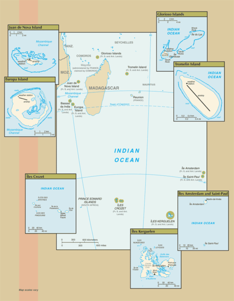
Map of the French Southern and Antarctic Lands, from CIA.gov
This image is in the public domain because it contains materials that originally came from the United States Central Intelligence Agency's World Factbook.
|
 |
Historial del fitxer
Cliqueu una data/hora per veure el fitxer tal com era aleshores.
| Data/hora | Miniatura | Dimensions | Usuari/a | Comentari | |
|---|---|---|---|---|---|
| actual | 12:14, 25 jul 2007 | | 690 × 887 (49 Ko) | Hoshie | Updated map of the French Southern and Antarctic Lands from the CIA World Factbook, 19 July 07 rev. Src: https://www.cia.gov/library/publications/the-world-factbook/maps/fs-map.gif |
| 11:12, 18 gen 2006 |  | 328 × 352 (7 Ko) | Hoshie | Map of the French Southern and Antarctic Lands, from [http://www.cia.gov/cia/publications/factbook/maps/fs-map.gif CIA.gov] {{PD-USGov-CIA-WF}} |
Ús del fitxer
La pàgina següent utilitza aquest fitxer:
Ús global del fitxer
Utilització d'aquest fitxer en altres wikis:
- Utilització a af.wikipedia.org
- Utilització a az.wikipedia.org
- Utilització a be-tarask.wikipedia.org
- Utilització a bn.wikipedia.org
- Utilització a cy.wikipedia.org
- Utilització a de.wikipedia.org
- Utilització a en.wikipedia.org
- Utilització a eo.wikipedia.org
- Utilització a es.wikipedia.org
- Utilització a frr.wikipedia.org
- Utilització a gl.wikipedia.org
- Utilització a id.wikipedia.org
- Utilització a it.wikipedia.org
- Utilització a lv.wikipedia.org
- Utilització a mk.wikipedia.org
- Utilització a mt.wikipedia.org
- Utilització a nds-nl.wikipedia.org
- Utilització a nn.wikipedia.org
- Utilització a ro.wikipedia.org
- Utilització a war.wikipedia.org
- Utilització a zh-yue.wikipedia.org
- Utilització a zh.wikipedia.org