Fitxer:United States 1860-1870.gif
No hi ha cap versió amb una resolució més gran.
United_States_1860-1870.gif (787 × 483 píxels, mida del fitxer: 49 Ko, tipus MIME: image/gif, en bucle, 28 fotogrames, 35 s)
| Aquest fitxer i la informació mostrada a continuació provenen del dipòsit multimèdia lliure Wikimedia Commons. |
Resum
| Descripció |
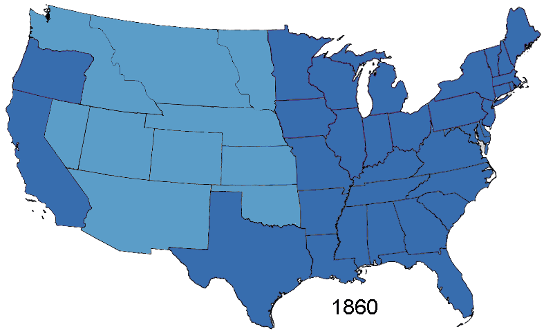
English: Animated map, about the American Civil War and the restoration of the southern states and the Union (made in Photoshop).
States of the Union (with full delegations in the U.S. Congress)
Union Territories (including the southern states before and during the war)
States of the Confederacy
Territories of the Confederacy |
| Font | Based on Creative Commons Licenced 1861 map and GNU-1864 Licenced map. Information from the Wikipedia articles Confederate States of America, List of US states by date of statehood, and has also just exterior sites When states Became states. Civil war borders Used from public domain Perry-Castañeda Library Map Collection 1861-1865 map. Border Between Arizona Territory (CSA) and New Mexico Territory Is That Depicted in public domain map Image: Map of CSA 4.png |
| Autor | User:Roke~commonswiki |
Llicència
As the maps this was based on were licenced as GFDL and creative commons (not including the public domain maps), this is licenced under both licences.

|
S'autoritza la còpia, la distribució i la modificació d'aquest document sota els termes de la llicència de documentació lliure GNU versió 1.2 o qualsevol altra versió posterior que publiqui la Free Software Foundation; sense seccions invariants, ni textos de portada, ni textos de contraportada. S'inclou una còpia d'aquesta llicència en la secció titulada GNU Free Documentation License. |
| Aquest fitxer està subjecte a la llicència de Creative Commons Reconeixement i Compartir Igual 3.0 No adaptada. | ||
| ||
| Aquest avís de llicència s'ha afegit a aquest fitxer d'acord amb l'actualització de la llicència GFDL. |
Aquest fitxer està publicat sota la llicència de Creative Commons Reconeixement i Compartir Igual 2.5 Genèrica.
- Sou lliure de:
- compartir – copiar, distribuir i comunicar públicament l'obra
- adaptar – fer-ne obres derivades
- Amb les condicions següents:
- reconeixement – Heu de donar la informació adequada sobre l'autor, proporcionar un enllaç a la llicència i indicar si s'han realitzat canvis. Podeu fer-ho amb qualsevol mitjà raonable, però de cap manera no suggereixi que l'autor us dóna suport o aprova l'ús que en feu.
- compartir igual – Si modifiqueu, transformeu, o generareu amb el material, haureu de distribuir les vostres contribucions sota una llicència similar o una de compatible com l'original
Historial del fitxer
Cliqueu una data/hora per veure el fitxer tal com era aleshores.
| Data/hora | Miniatura | Dimensions | Usuari/a | Comentari | |
|---|---|---|---|---|---|
| actual | 16:02, 2 gen 2015 | | 787 × 483 (49 Ko) | Sapph | Fixed incorrect succession order of North Carolina and Tennessee by swapping frames 10 and 11. |
| 07:00, 2 ago 2006 |  | 787 × 483 (49 Ko) | Roke~commonswiki | Animated map showing Confederacy, American Civil War and re-admission of southern states to the Union, made in Photoshop. {{legend|#376dae|States of the Union}} {{legend|#5b9dc8|Territories of the Union (including occupied territory during and after the |
Ús del fitxer
La pàgina següent utilitza aquest fitxer:
Ús global del fitxer
Utilització d'aquest fitxer en altres wikis:
- Utilització a af.wikipedia.org
- Utilització a ar.wikipedia.org
- Utilització a bn.wikipedia.org
- Utilització a cs.wikipedia.org
- Utilització a en.wikipedia.org
- Historical regions of the United States
- History of the Southern United States
- Wikipedia:Featured picture candidates/March-2007
- Wikipedia:Featured picture candidates/CSA states evolution.gif
- Portal:American Civil War/Intro/images
- Portal:American Civil War/Intro/images/rotation/41
- Talk:United States/Archive 36
- Utilització a es.wikipedia.org
- Utilització a eu.wikipedia.org
- Utilització a fa.wikipedia.org
- Utilització a fr.wikipedia.org
- Utilització a it.wikipedia.org
- Utilització a ja.wikipedia.org
- Utilització a lt.wikipedia.org
- Utilització a ms.wikipedia.org
- Utilització a pt.wikipedia.org
- Utilització a www.wikidata.org