Fitxer:Urbanized population 2006.png

Mida d'aquesta previsualització: 800 × 364 píxels. Altres resolucions: 320 × 146 píxels | 640 × 292 píxels | 1.024 × 466 píxels | 1.280 × 583 píxels | 3.600 × 1.640 píxels.
Fitxer original (3.600 × 1.640 píxels, mida del fitxer: 550 Ko, tipus MIME: image/png)
| Aquest fitxer i la informació mostrada a continuació provenen del dipòsit multimèdia lliure Wikimedia Commons. |
Resum
| Descripció |
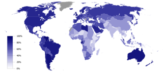
English: Urbanized population percentage by country as of 2006. Source: UNICEF, The State of the World’s Children 2008 (p. 134)
Aquesta imatge ha estat creada amb GunnMap GunnMap was created by Arthur Gunn and is available, free, at http://gunn.co.nz/map/ and http://gunnmap.herokuapp.com/. Please attribute by linking to http://gunn.co.nz/map/. |
| Data | |
| Font | Based on BlankMap-World6, compact.svg by Canuckguy et al. |
| Autor | Jelle564 |
Llicència
| Jo, el titular del copyright d'aquesta obra, l'allibero al domini públic. Això s'aplica a tot el món. En alguns països això pot no ser legalment possible, en tal cas: Jo faig concessió a tothom del dret d'usar aquesta obra per a qualsevol propòsit, sense cap condició llevat d'aquelles requerides per la llei. |
Historial del fitxer
Cliqueu una data/hora per veure el fitxer tal com era aleshores.
| Data/hora | Miniatura | Dimensions | Usuari/a | Comentari | |
|---|---|---|---|---|---|
| actual | 15:41, 19 feb 2017 | | 3.600 × 1.640 (550 Ko) | Zywang114072 | Change and update country urbanized population degree color: Taiwan |
| 18:48, 16 gen 2009 |  | 3.600 × 1.640 (362 Ko) | Jelle564 | {{Information |Description={{en|1=Urbanized population percentage by country as of 2006. Source: http://www.unicef.org/sowc08/docs/sowc08_table_StatisticalTables.pdf {{GunnMap}}}} |Source=Based on [[:Image:BlankMap-World6, compact.svg|BlankMap-World6, com |
Ús del fitxer
Les 2 pàgines següents utilitzen aquest fitxer:
Ús global del fitxer
Utilització d'aquest fitxer en altres wikis:
- Utilització a ar.wikipedia.org
- Utilització a bg.wikipedia.org
- Utilització a es.wikipedia.org
- Utilització a fa.wikipedia.org
- Utilització a gu.wikipedia.org
- Utilització a it.wikipedia.org
- Utilització a ka.wikipedia.org
- Utilització a la.wikipedia.org
- Utilització a lt.wikipedia.org
- Utilització a nl.wikipedia.org
- Utilització a nn.wikipedia.org
- Utilització a no.wikipedia.org
- Utilització a pl.wikipedia.org
- Utilització a pt.wikipedia.org
- Utilització a ta.wikipedia.org
- Utilització a ur.wikipedia.org