Fitxer:Williams-Point.jpg
Mida d'aquesta previsualització: 800 × 599 píxels. Altres resolucions: 320 × 240 píxels | 640 × 479 píxels | 1.024 × 766 píxels | 1.280 × 958 píxels | 2.608 × 1.952 píxels.
Fitxer original (2.608 × 1.952 píxels, mida del fitxer: 1,82 Mo, tipus MIME: image/jpeg)
| Aquest fitxer i la informació mostrada a continuació provenen del dipòsit multimèdia lliure Wikimedia Commons. |
Resum
| Descripció |
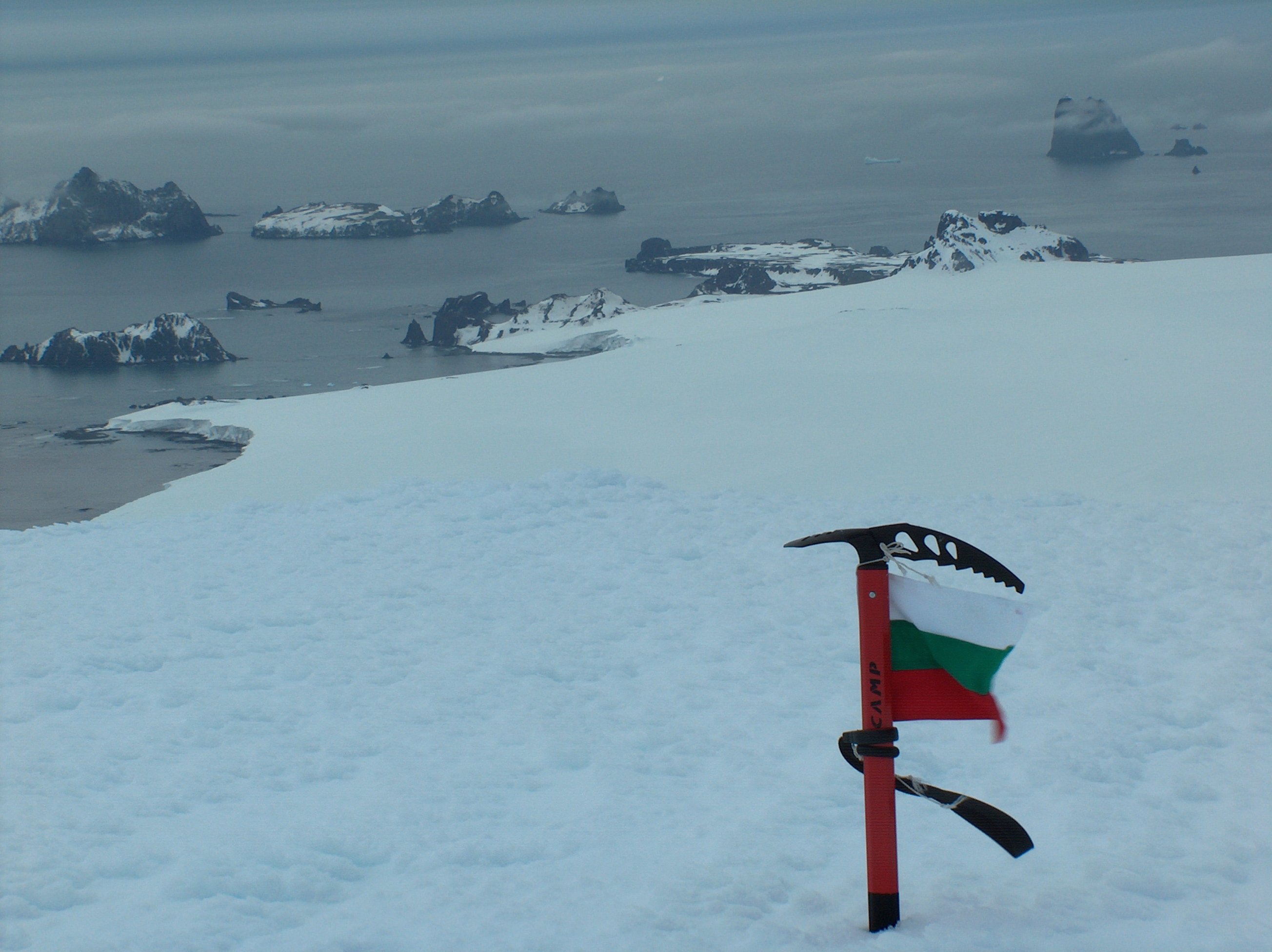
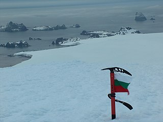
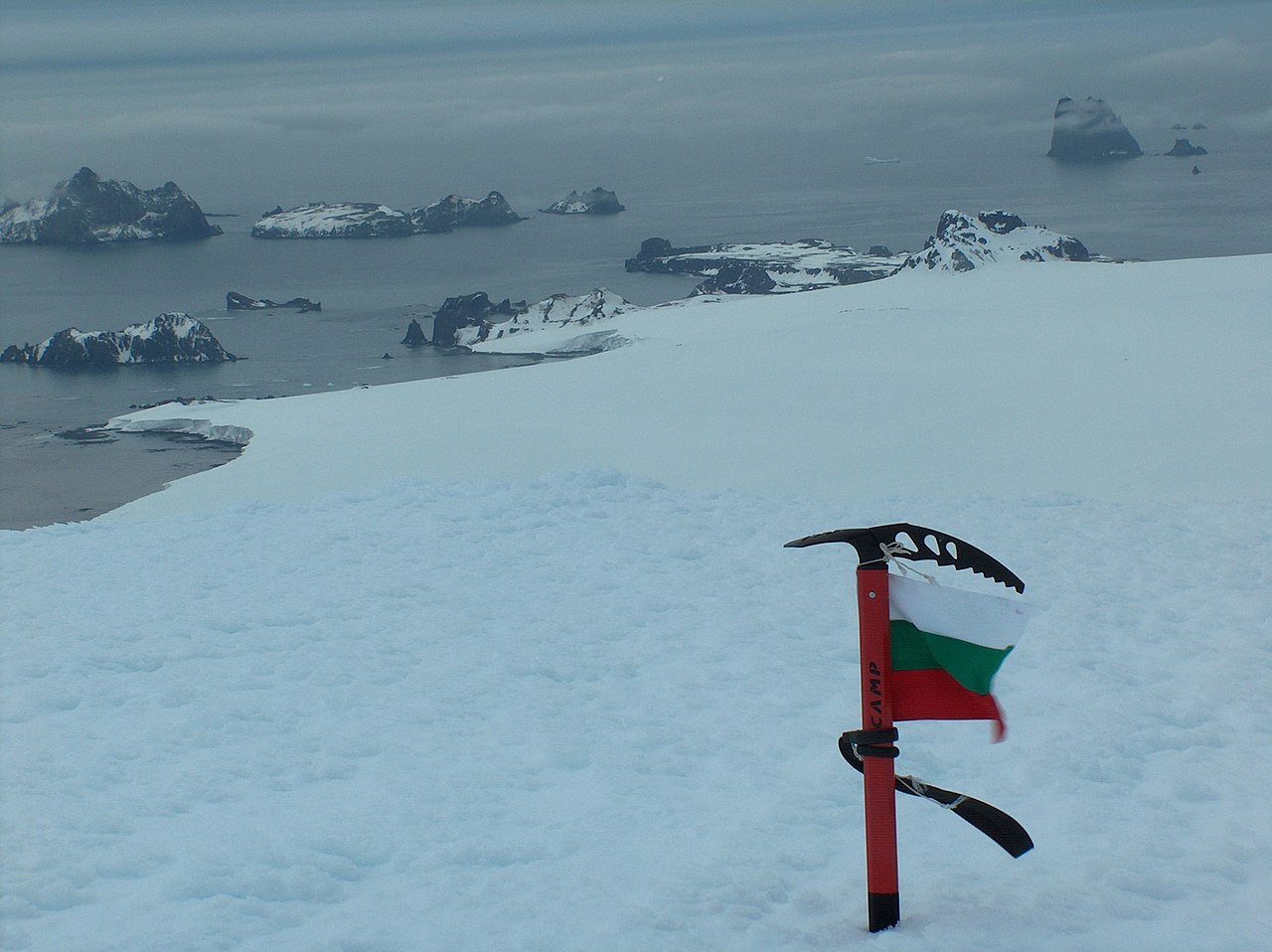
English: Williams Point, Livingston Island in the South Shetland Islands; the first land ever discovered south of 60˚ south latitude, on February 19, 1819. Left to right Slab Point, Organpipe Point, and Williams Point surmounted by Sayer Nunatak, from Miziya Peak, with Zavala Island in the foreground, Zed Islands in the left background, and Pyramid Island on the right
Español: Punta Williams, descubierto el 19 de febrero de 1819 |
| Data | |
| Font | Treball propi |
| Autor | Apcbg |
| Posició de la càmera | | Aquesta i altres imatges properes a: OpenStreetMap |
|---|
Llicència
Jo, el titular dels drets d'autor d'aquest treball, el public sota la següent llicència:
This file is licensed under the Creative Commons Attribution-Share Alike 4.0 International license.
- Sou lliure de:
- compartir – copiar, distribuir i comunicar públicament l'obra
- adaptar – fer-ne obres derivades
- Amb les condicions següents:
- reconeixement – Heu de donar la informació adequada sobre l'autor, proporcionar un enllaç a la llicència i indicar si s'han realitzat canvis. Podeu fer-ho amb qualsevol mitjà raonable, però de cap manera no suggereixi que l'autor us dóna suport o aprova l'ús que en feu.
- compartir igual – Si modifiqueu, transformeu, o generareu amb el material, haureu de distribuir les vostres contribucions sota una llicència similar o una de compatible com l'original
Historial del fitxer
Cliqueu una data/hora per veure el fitxer tal com era aleshores.
| Data/hora | Miniatura | Dimensions | Usuari/a | Comentari | |
|---|---|---|---|---|---|
| actual | 10:59, 2 abr 2019 | | 2.608 × 1.952 (1,82 Mo) | Apcbg | original |
| 21:32, 26 abr 2006 |  | 2.236 × 1.673 (559 Ko) | Apcbg | {{ConfirmationOTRS|otrs=2006013010000528|source=Lyubomir Ivanov}} |
Ús del fitxer
Les 2 pàgines següents utilitzen aquest fitxer:
Ús global del fitxer
Utilització d'aquest fitxer en altres wikis:
- Utilització a als.wikipedia.org
- Utilització a ar.wikipedia.org
- Utilització a ast.wikipedia.org
- Utilització a az.wikipedia.org
- Utilització a bg.wikipedia.org
- Utilització a ceb.wikipedia.org
- Utilització a ce.wikipedia.org
- Utilització a cv.wikipedia.org
- Utilització a da.wikipedia.org
- Utilització a de.wikipedia.org
- Utilització a en.wikipedia.org
- Utilització a en.wikivoyage.org
- Utilització a eo.wikipedia.org
- Utilització a es.wikipedia.org
- Utilització a eu.wikipedia.org
- Utilització a fi.wikipedia.org
- Utilització a fr.wikipedia.org
- Utilització a he.wikipedia.org
- Utilització a hu.wikipedia.org
- Utilització a it.wikipedia.org
- Utilització a ja.wikipedia.org
- Utilització a ka.wikipedia.org
- Utilització a mk.wikipedia.org
Vegeu més usos globals d'aquest fitxer.