Fitxer:SDLIMITS.jpg

Mida d'aquesta previsualització: 776 × 599 píxels. Altres resolucions: 311 × 240 píxels | 622 × 480 píxels | 994 × 768 píxels | 1.200 × 927 píxels.
Fitxer original (1.200 × 927 píxels, mida del fitxer: 165 Ko, tipus MIME: image/jpeg)
| Aquest fitxer i la informació mostrada a continuació provenen del dipòsit multimèdia lliure Wikimedia Commons. |
Resum
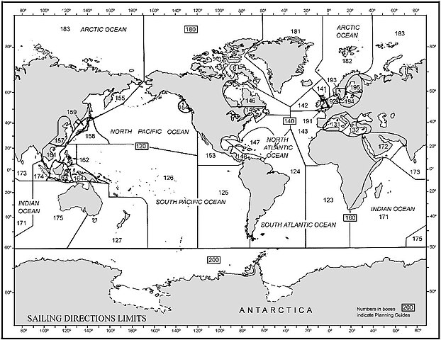
This Graphic is taken from http://msi.nga.mil/MSISiteContent/StaticFiles/Images/SDLIMITS.jpg
Graphic overview (world map) with limits of the Sailing Directions volumes of the U.S. NIMA (National Imagery and Mapping Agency) which can be downloaded starting at page http://permanent.access.gpo.gov/websites/pollux/pollux.nss.nima.mil/NAV_PUBS/SD/
The sailing directions can be found with this URL: [1] (replace the last three digits by the actual number)
Llicència
Aquesta obra és en el domini públic als Estats Units perquè és una obra del govern federal dels Estats Units sota els termes del Títol 17, Capítol 1, Secció 105 del Codi dels EUA. Vegeu drets d'autor.
Nota: Això només s'aplica a obres del Govern Federal i no a les dels estats individuals ni cap altra subdivisió administrativa. Aquesta plantilla tampoc no s'aplica a dissenys de segells de correus publicats pel Servei Postal dels Estats Units des de 1978 (vegeu 206.02(b) of Compendium II: Copyright Office Practices).
|
 | |
| Aquest fitxer està identificat com a lliure de restriccions conegudes sota la llei de drets d'autor, inclosos els drets veïns. | ||
Historial del fitxer
Cliqueu una data/hora per veure el fitxer tal com era aleshores.
| Data/hora | Miniatura | Dimensions | Usuari/a | Comentari | |
|---|---|---|---|---|---|
| actual | 22:50, 10 oct 2006 | | 1.200 × 927 (165 Ko) | Ratzer | Graphic overview (world map) with limits of the Sailing Directions volumes of the U.S. NIMA (National Imagery and Mapping Agency) which can be downloaded starting at page http://permanent.access.gpo.gov/websites/pollux/pollux.nss.nima.mil/NAV_PUBS/SD/ |
Ús del fitxer
Les 2 pàgines següents utilitzen aquest fitxer:
Ús global del fitxer
Utilització d'aquest fitxer en altres wikis:
- Utilització a de.wikipedia.org
- Utilització a en.wikipedia.org
- Utilització a es.wikipedia.org
- Utilització a fr.wikipedia.org
- Utilització a lv.wikipedia.org