Fitxer:Übersichtskarte Loveparade Duisburg 2010.jpg
No hi ha cap versió amb una resolució més gran.
Übersichtskarte_Loveparade_Duisburg_2010.jpg (400 × 400 píxels, mida del fitxer: 105 Ko, tipus MIME: image/jpeg)
| Aquest fitxer i la informació mostrada a continuació provenen del dipòsit multimèdia lliure Wikimedia Commons. |

|
Aquesta imatge (de tipus road map) s'hauria de tornar a crear utilitzant gràfics vectorials com ara un fitxer SVG. Això té diversos avantatges; en trobareu més informació a Commons:Media for cleanup. Si ja disposeu d'una versió d'aquesta imatge en format SVG, us preguem que la pengeu; després, reemplaceu aquesta plantilla amb la plantilla {{Vector version available|nom nou de la imatge.svg}} en aquesta imatge.
|


| Descripció |
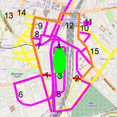
English: Overview on loveparade 2010 in Duisburg |
|||||
| Data | ||||||
| Font | Treball propi, based on OpenStreetMap data published under CC-BY-SA 2.0 | |||||
| Autor | user:axpde | |||||
| Permís (Com reutilitzar aquest fitxer) |
|

| Farbe / Ziffer | Erklärung | Explanation | Ort |
|---|---|---|---|
| Rot | Sicherheitsschleusen | security ports | |
| Orange | Geplante Fußwege | planned Footpaths | |
| Gelb | Tatsächliche genutzte Wege | actually used paths | |
| Magenta | Rettungswege | emergency paths | |
| Grün | Festivalgelände | festival area | |
| 1 | Westliche Sicherheitsschleuse | western security port | Karl-Lehr-Straße / Düsseldorfer Straße |
| 2 | Östliche Sicherheitsschleuse | eastern security port | Karl-Lehr-Straße / Grabenstraße |
| 3 | Haupteingang (zwei 20 m breite Tunnel, eine 50 m breite Rampe) | main entry (two tunnel of 20 m width, a ramp of 50 m width) | Karl-Lehr-Straße |
| 4 | VIP-Eingang / nördlicher Rettungsweg | VIP entry / northern escape way | Am Güterbahnhof |
| 5 | Südlicher Rettungsweg / Sanitätsdienst | southern escape way / medical service | Grunewald |
| 6 | Bethesda-Johanniter-Klinikum | Bethesda Hospitaller clinical center | |
| 7 | VIP-Eingang / Sanitätsdient | VIP entry / medical service | Mercatorstraße |
| 8 | Sanitätsdienstzentrale | central medical service | Steinbart-Gymnasium |
| 9 | Behelfshubschrauberlandeplatz | emergency heliport | Kantpark |
| 10 | Sanitätsdienst | medical service | Kammerstraße, Gertrud-Bäumer-Schule |
| 11 | Behelfshubschrauberlandeplatz | emergency heliport | Ludgeriplatz |
| 12 | Duisburg Hauptbahnhof | Duisburg central station | |
| 13 | Zentraler Omnibusbahnhof / U-Bahnhof | central bus station / underground station | Steinsche Gasse |
| 14 | „Nebenschauplatz“ | „Sideshow“ | Friedrich-Wilhelm-Platz |
| 15 | „Nebenschauplatz“ | „Sideshow“ | Neudorfer Markt |
Historial del fitxer
Cliqueu una data/hora per veure el fitxer tal com era aleshores.
| Data/hora | Miniatura | Dimensions | Usuari/a | Comentari | |
|---|---|---|---|---|---|
| actual | 19:01, 27 jul 2010 | | 400 × 400 (105 Ko) | Axpde | some additions |
Ús del fitxer
La pàgina següent utilitza aquest fitxer:
Ús global del fitxer
Utilització d'aquest fitxer en altres wikis:
- Utilització a ar.wikipedia.org
- Utilització a bg.wikipedia.org
- Utilització a de.wikipedia.org
- Utilització a en.wikipedia.org
- Utilització a fi.wikipedia.org
- Utilització a id.wikipedia.org
- Utilització a it.wikipedia.org
- Utilització a nds.wikipedia.org
- Utilització a nl.wikipedia.org
- Utilització a ru.wikipedia.org
- Utilització a vec.wikipedia.org
- Utilització a www.wikidata.org