Fitxer:Anglo.Saxon.migration.5th.cen.jpg
Fitxer original (1.800 × 1.703 píxels, mida del fitxer: 875 Ko, tipus MIME: image/jpeg)
| Aquest fitxer i la informació mostrada a continuació provenen del dipòsit multimèdia lliure Wikimedia Commons. |

|
Aquesta imatge (de tipus historical map) s'hauria de tornar a crear utilitzant gràfics vectorials com ara un fitxer SVG. Això té diversos avantatges; en trobareu més informació a Commons:Media for cleanup. Si ja disposeu d'una versió d'aquesta imatge en format SVG, us preguem que la pengeu; després, reemplaceu aquesta plantilla amb la plantilla {{Vector version available|nom nou de la imatge.svg}} en aquesta imatge.
|


Resum
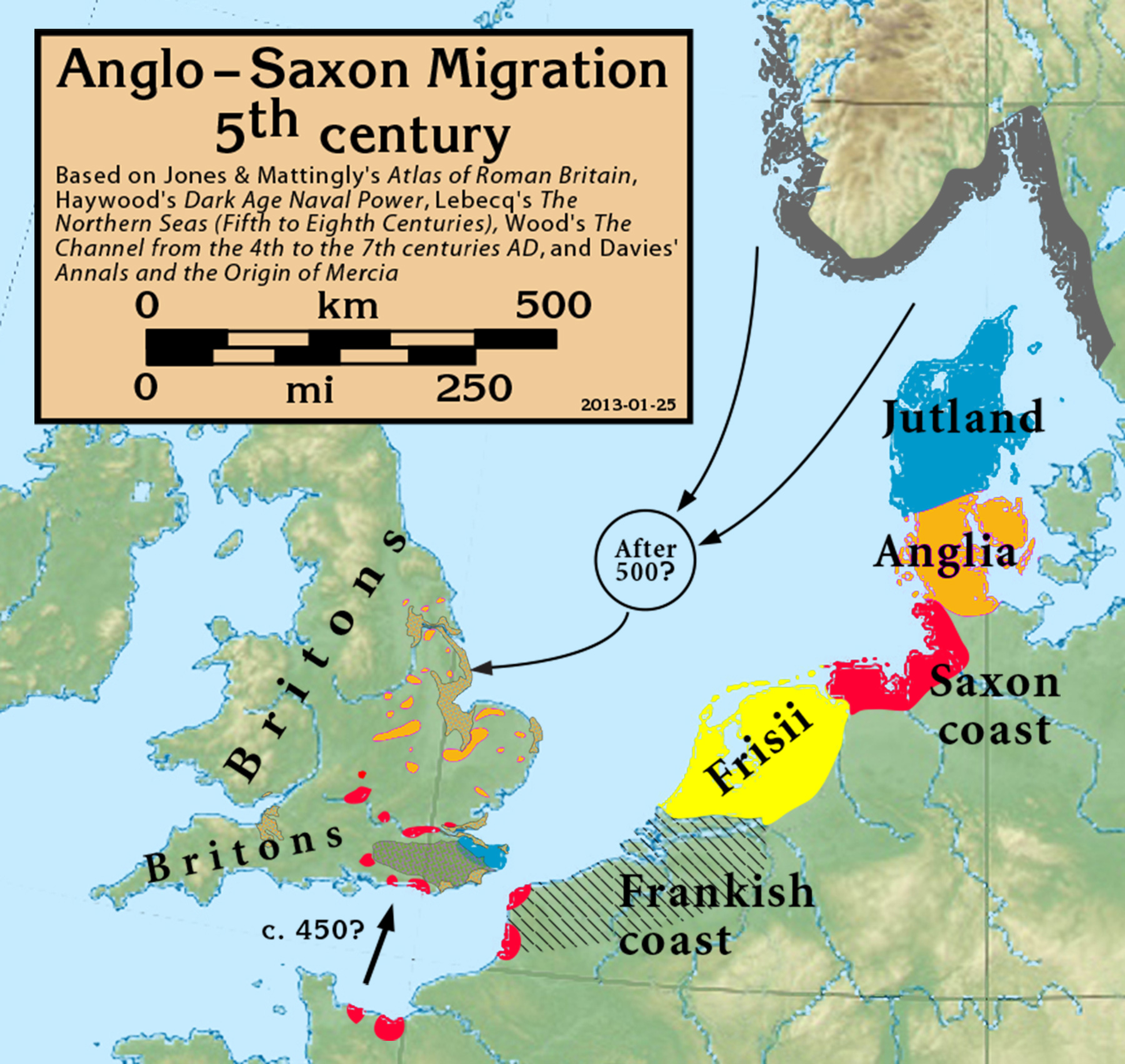
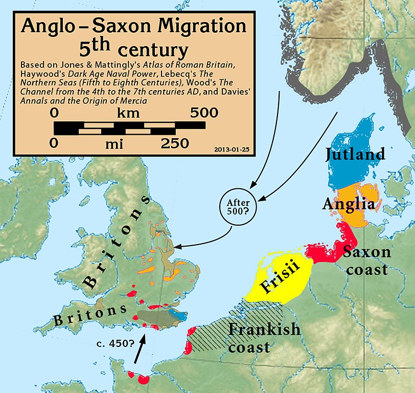
| Descripció | Anglo-Saxon Migration in the 5th century |
| Data | |
| Font |
Based on Jones & Mattingly's Atlas of Roman Britain (ISBN 978-1-84217-06700, 1990, reprinted 2007, pp. 317, 318), Haywood's Dark Age Naval Power (ISBN 1-898281-43-2, 1999, cemeteries on pp. 84–86, 121, region of "Romanisation" on p. 151), Lebecq's The Northern Seas (fifth to eighth centuries) (in The New Cambridge Medieval History, Vol I c.500–c.700, ISBN 13-978-0-521-36291-7, 2005, p. 643), and Wood's The Channel from the 4th to the 7th centuries AD in Carver's Maritime Celts, Frisians and Saxons (ISBN 978-0906780930, pp 93–97). The suggestion that settlements in Britain were made from the Bessin is from Haywood (Vron, for example, was abandoned c. 450). Jones & Mattingly also show 5th century cemeteries in the central English Midlands south of the River Trent, based on the dating of excavated cemeteries, but this is disputed by historians arguing for a 6th century Anglo-Saxon expansion into that region (see, for example Annals and the Origin of Mercia, pp. 20–24, by Wendy Davies, in Mercian Studies, 1977, ISBN 0718511484).
|
| Autor | my work |
Llicència
- Sou lliure de:
- compartir – copiar, distribuir i comunicar públicament l'obra
- adaptar – fer-ne obres derivades
- Amb les condicions següents:
- reconeixement – Heu de donar la informació adequada sobre l'autor, proporcionar un enllaç a la llicència i indicar si s'han realitzat canvis. Podeu fer-ho amb qualsevol mitjà raonable, però de cap manera no suggereixi que l'autor us dóna suport o aprova l'ús que en feu.
- compartir igual – Si modifiqueu, transformeu, o generareu amb el material, haureu de distribuir les vostres contribucions sota una llicència similar o una de compatible com l'original
Historial del fitxer
Cliqueu una data/hora per veure el fitxer tal com era aleshores.
| Data/hora | Miniatura | Dimensions | Usuari/a | Comentari | |
|---|---|---|---|---|---|
| actual | 19:05, 27 set 2021 | | 1.800 × 1.703 (875 Ko) | GPinkerton | Reverted to version as of 16:39, 25 January 2013 (UTC) COM:CROP |
| 17:57, 19 maig 2020 |  | 1.800 × 1.703 (885 Ko) | Claude Zygiel | Shoreline (high tide) of this time + Flevo lake (the british bank of North Sea was lower but in tectonic rise, the continental bank was upper but in subsidence) | |
| 18:39, 25 gen 2013 |  | 1.800 × 1.703 (875 Ko) | Notuncurious | minor cleanup and improvement | |
| 22:29, 24 gen 2013 |  | 2.635 × 2.451 (932 Ko) | Notuncurious | User created page with UploadWizard |
Ús del fitxer
Les 3 pàgines següents utilitzen aquest fitxer:
Ús global del fitxer
Utilització d'aquest fitxer en altres wikis:
- Utilització a ar.wikipedia.org
- Utilització a arz.wikipedia.org
- Utilització a azb.wikipedia.org
- Utilització a br.wikipedia.org
- Utilització a cs.wikipedia.org
- Utilització a de.wikipedia.org
- Utilització a en.wikipedia.org
- Utilització a es.wikipedia.org
- Utilització a et.wikipedia.org
- Utilització a eu.wikipedia.org
- Utilització a fi.wikipedia.org
- Utilització a fr.wikipedia.org
- Utilització a fy.wikipedia.org
- Utilització a ga.wikipedia.org
- Utilització a he.wikipedia.org
- Utilització a hr.wikipedia.org
- Utilització a hu.wikipedia.org
- Utilització a hy.wikipedia.org
- Utilització a id.wikipedia.org
- Utilització a it.wikipedia.org
- Utilització a mk.wikipedia.org
- Utilització a ms.wikipedia.org
- Utilització a nl.wikipedia.org
- Utilització a pl.wikipedia.org
- Utilització a pt.wikipedia.org
- Utilització a ru.wikipedia.org
- Utilització a sh.wikipedia.org
- Utilització a simple.wikipedia.org
- Utilització a sk.wikipedia.org
- Utilització a sl.wikipedia.org
- Utilització a sr.wikipedia.org
- Utilització a sv.wikipedia.org
Vegeu més usos globals d'aquest fitxer.