Fitxer:Basin of Lop Nur 90.25E, 40.10N, Kum Tagh and Astin Tagh.jpg
No hi ha cap versió amb una resolució més gran.
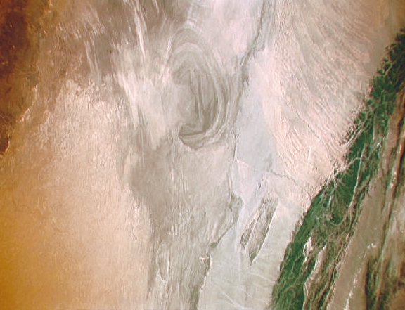
Basin_of_Lop_Nur_90.25E,_40.10N,_Kum_Tagh_and_Astin_Tagh.jpg (576 × 441 píxels, mida del fitxer: 176 Ko, tipus MIME: image/jpeg)
| Aquest fitxer i la informació mostrada a continuació provenen del dipòsit multimèdia lliure Wikimedia Commons. |
Resum
| Descripció |
English: China, Xinjiang, desert Lop Nur. Satellite picture of the Basin of the formerly sea Lop Nur in the Desert of Lop Nur. In the foreground Kuruktagh, in the background Kumtagh and Astintagh.
Deutsch: China, Xinjiang, Wüste Lop Nor. Satellitenaufnahme von dem mittleren Teil des Seebeckens Lop Nor und der Wüste Lop Nor. Links im Vordergrund sieht man einen Teil des Gebirges Kuruktagh mit Kratern des Kernwaffentestgeländes, im Hintergrund die Hänge des Kumtagh und die Hochebene des Astintagh. Blick von Nordwesten Richtung Südosten. |
| Data | entre 12 de setembre de 1992 i 20 de setembre de 1992 |
| Font | NASA Mission: STS047 Roll: 217 Frame: 33 Mission ID on the Film or image: STS47. File name: STS047-217-33.JPG [1] |
| Autor | NASA. Color adjusting of this image (using Adobe Photoshop 6.0): Michael Gaebler, 02. March 2006, own work, all rights released (Public domain). de: Zugrunde liegt ein noch nicht farbrichtiges Astronauten-Foto der NASA. Diese Fotografie wurde von Michael Gaebler am 02. März 2006 im RGB-Modus mit Adobe Photoshop 6.0 mit Farb- und Tonwertkorrekturen überarbeitet. |
| Permís (Com reutilitzar aquest fitxer) |
PD-USGov-NASA |
Aquest fitxer ha estat catalogat per una de les centrals dels Estats Units d'Amèrica per a l'Administració Nacional d'Aeronàutica i de l'Espai (NASA)en virtut identificat com a: ID del fitxer : STS047-217-33.Els ID dels fitxers i ID alternatius són traduïts de Photo ID .Aquesta etiqueta no indica l'estat dels drets d'autor de la imatge carregada. Cal un senyal de drets d'autor. Vegeu Commons:Sobre les llicències. Altres idiomes:
|
Llicència
| Aquest fitxer és en el domini públic perquè ha estat creat per la NASA. L'avís legal de la NASA diu que «el material de la NASA no està protegit per copyright si no es diu el contrari». (NASA copyright policy page o JPL Image Use Policy). | ||
 |
Atenció:
|
Historial del fitxer
Cliqueu una data/hora per veure el fitxer tal com era aleshores.
| Data/hora | Miniatura | Dimensions | Usuari/a | Comentari | |
|---|---|---|---|---|---|
| actual | 17:57, 23 des 2012 | | 576 × 441 (176 Ko) | Rotatebot | Bot: Image rotated by 90° |
| 02:42, 6 març 2006 |  | 441 × 585 (178 Ko) | Michael Gäbler | {{Information| |Description = en: China, Xinjiang, desert Lop Nur. Satellite picture of the Basin of the formerly sea Lop Nur in the desert of Lop. In the foreground Kuruktagh, in the background Kumtagh and Astintagh. de: China, Xinjiang, W� |
Ús del fitxer
La pàgina següent utilitza aquest fitxer:
Ús global del fitxer
Utilització d'aquest fitxer en altres wikis:
- Utilització a ar.wikipedia.org
- Utilització a az.wikipedia.org
- Utilització a bg.wikipedia.org
- Utilització a de.wikipedia.org
- Utilització a en.wikipedia.org
- Utilització a en.wikivoyage.org
- Utilització a eo.wikipedia.org
- Utilització a es.wikipedia.org
- Utilització a es.wikivoyage.org
- Utilització a et.wikipedia.org
- Utilització a gd.wikipedia.org
- Utilització a he.wikipedia.org
- Utilització a he.wikivoyage.org
- Utilització a hi.wikipedia.org
- Utilització a hu.wikipedia.org
- Utilització a hy.wikipedia.org
- Utilització a id.wikipedia.org
- Utilització a it.wikipedia.org
- Utilització a ka.wikipedia.org
- Utilització a kk.wikipedia.org
- Utilització a ko.wikipedia.org
- Utilització a lt.wikipedia.org
- Utilització a mk.wikipedia.org
- Utilització a nl.wikipedia.org
- Utilització a pt.wikipedia.org
- Utilització a ru.wikipedia.org
- Utilització a sh.wikipedia.org
- Utilització a sl.wikipedia.org
- Utilització a te.wikipedia.org
- Utilització a ug.wikipedia.org
- Utilització a www.wikidata.org
- Utilització a zh.wikivoyage.org