Fitxer:Bissagos archipel-satellite.jpg
Mida d'aquesta previsualització: 600 × 600 píxels. Altres resolucions: 240 × 240 píxels | 480 × 480 píxels | 768 × 768 píxels | 1.024 × 1.024 píxels | 2.048 × 2.048 píxels | 5.264 × 5.264 píxels.
Fitxer original (5.264 × 5.264 píxels, mida del fitxer: 10,16 Mo, tipus MIME: image/jpeg)
| Aquest fitxer i la informació mostrada a continuació provenen del dipòsit multimèdia lliure Wikimedia Commons. |
Resum
| Descripció |
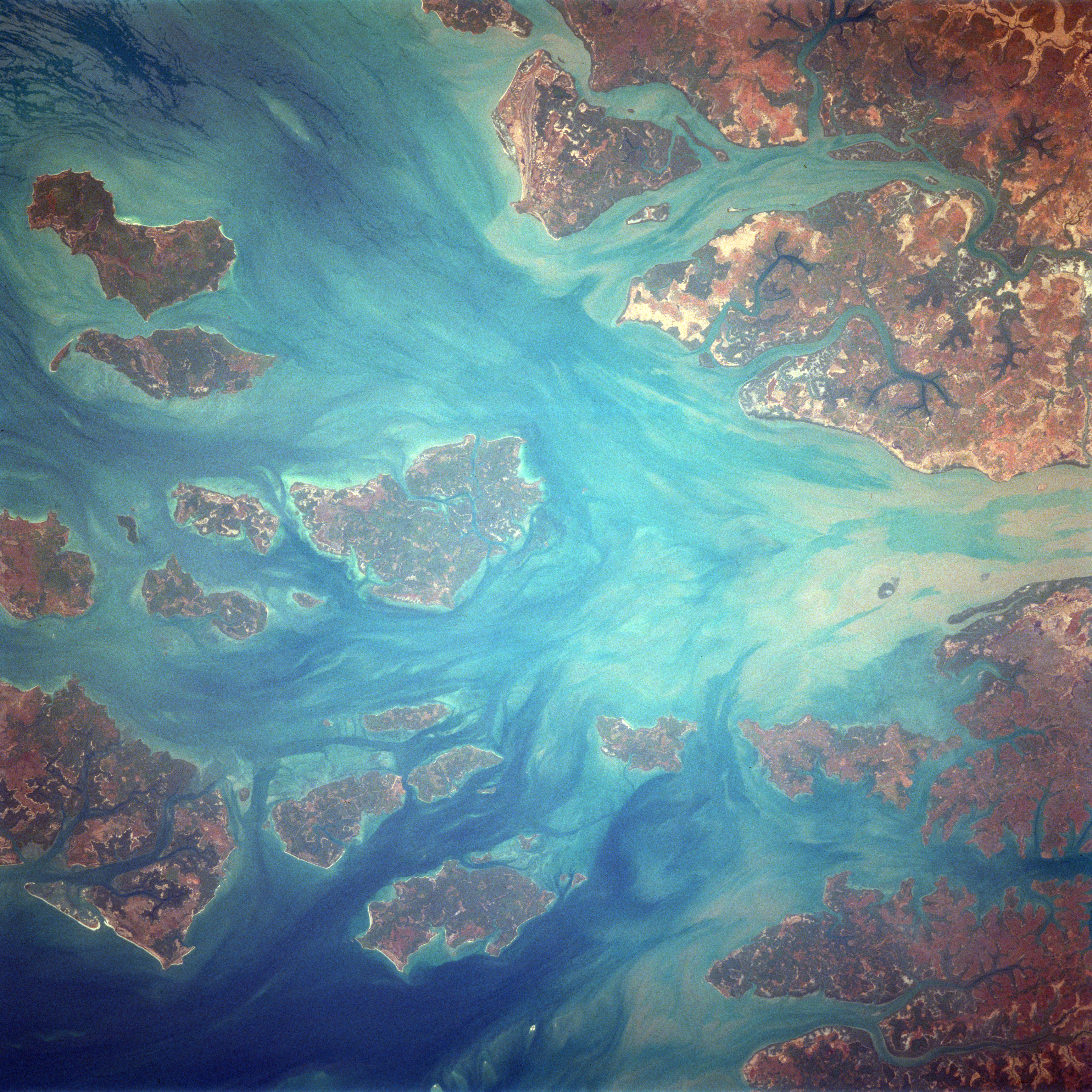
English: Bissagos Archipel
Identification Mission: STS037 Roll: 77 Frame: 71 Mission ID on the Film or image: STS37 Country or Geographic Name: GUINEA-BISSAU Features: ARQUIPELAGO DOS BIJAGOS Center Point Latitude: 11.5 Center Point Longitude: -15.9 (Negative numbers indicate south for latitude and west for longitude) |
| Data | Taken on 6 d'abril de 1991, 14:04:51 UTC |
| Font | https://eol.jsc.nasa.gov/SearchPhotos/photo.pl?mission=STS037&roll=77&frame=71 |
| Autor | NASA / Crew of STS-37 |
Aquest fitxer ha estat catalogat per Johnson Space Center dels Estats Units d'Amèrica per a l'Administració Nacional d'Aeronàutica i de l'Espai (NASA)en virtut identificat com a: ID del fitxer : STS037-77-71.Els ID dels fitxers i ID alternatius són traduïts de Photo ID .Aquesta etiqueta no indica l'estat dels drets d'autor de la imatge carregada. Cal un senyal de drets d'autor. Vegeu Commons:Sobre les llicències. Altres idiomes:
|
Llicència
This file is in the public domain in the United States because it was created by the Image Science & Analysis Laboratory, of the NASA Johnson Space Center. NASA copyright policy states that "NASA material is not protected by copyright unless noted". (NASA media use guidelines or Conditions of Use of Astronaut Photographs).
Photo source: STS037-77-71.
|
Registre original de càrregues
Originally from de.wikipedia; description page is/was here[dead link]. (All user names refer to de.wikipedia)
- 2004-09-19 09:05 MatthiasKabel 454×458×8 (41870 bytes) Bissagos Archipel, von http://eol.jsc.nasa.gov/scripts/sseop/QuickView.pl?directory=ISD&ID=STS037-77-72, public domain
Historial del fitxer
Cliqueu una data/hora per veure el fitxer tal com era aleshores.
| Data/hora | Miniatura | Dimensions | Usuari/a | Comentari | |
|---|---|---|---|---|---|
| actual | 19:30, 17 feb 2018 | | 5.264 × 5.264 (10,16 Mo) | Ras67 | high resolution, rotated to approximate north direction |
| 10:36, 27 feb 2007 |  | 454 × 458 (41 Ko) | Hardscarf | {{Information |Description=Bissagos Archipel Identification Mission: STS037 Roll: 77 Frame: 71 Mission ID on the Film or image: STS37 Country or Geographic Name: GUINEA-BISSAU Features: ARQUIPELAGO DOS BIJAGOS Center Point Latitude: 11.5 Center Point Lon |
Ús del fitxer
La pàgina següent utilitza aquest fitxer:
Ús global del fitxer
Utilització d'aquest fitxer en altres wikis:
- Utilització a ceb.wikipedia.org
- Utilització a de.wikivoyage.org
- Utilització a en.wikivoyage.org
- Utilització a he.wikivoyage.org
- Utilització a it.wikipedia.org
- Utilització a nl.wikipedia.org
- Utilització a pl.wikipedia.org
- Utilització a uk.wikipedia.org
- Utilització a www.wikidata.org