Fitxer:Borobudur Map en.svg

Mida d'aquesta previsualització PNG del fitxer SVG: 800 × 444 píxels. Altres resolucions: 320 × 178 píxels | 640 × 356 píxels | 1.024 × 569 píxels | 1.280 × 711 píxels | 2.560 × 1.422 píxels | 828 × 460 píxels.
Fitxer original (fitxer SVG, nominalment 828 × 460 píxels, mida del fitxer: 132 Ko)
| Aquest fitxer i la informació mostrada a continuació provenen del dipòsit multimèdia lliure Wikimedia Commons. |
Resum
| Descripció |
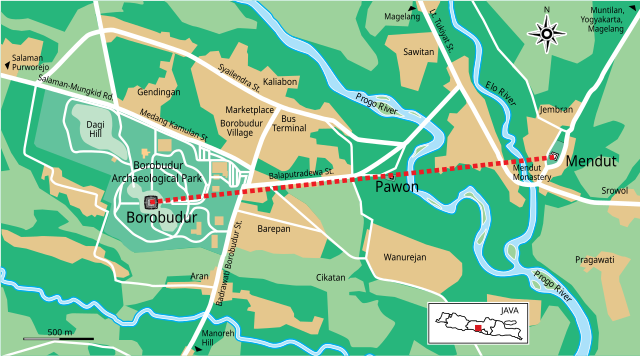
English: The map of Borobudur Archaeological Park and its surrounding, showing that Mendut, Pawon, and Borobudur forming a straight line. Self made, redrawed from google map. |
| Data | |
| Font | Treball propi |
| Autor | Gunawan Kartapranata |
| Altres versions |
[]
|


Llicència
Jo, el titular dels drets d'autor d'aquest treball, el public sota les següents llicències:
Aquest fitxer està subjecte a la llicència de Creative Commons Reconeixement i Compartir Igual 3.0 No adaptada.
- Sou lliure de:
- compartir – copiar, distribuir i comunicar públicament l'obra
- adaptar – fer-ne obres derivades
- Amb les condicions següents:
- reconeixement – Heu de donar la informació adequada sobre l'autor, proporcionar un enllaç a la llicència i indicar si s'han realitzat canvis. Podeu fer-ho amb qualsevol mitjà raonable, però de cap manera no suggereixi que l'autor us dóna suport o aprova l'ús que en feu.
- compartir igual – Si modifiqueu, transformeu, o generareu amb el material, haureu de distribuir les vostres contribucions sota una llicència similar o una de compatible com l'original

|
S'autoritza la còpia, la distribució i la modificació d'aquest document sota els termes de la llicència de documentació lliure GNU versió 1.2 o qualsevol altra versió posterior que publiqui la Free Software Foundation; sense seccions invariants, ni textos de portada, ni textos de contraportada. S'inclou una còpia d'aquesta llicència en la secció titulada GNU Free Documentation License. |
Podeu seleccionar la llicència que vulgueu.
Historial del fitxer
Cliqueu una data/hora per veure el fitxer tal com era aleshores.
| Data/hora | Miniatura | Dimensions | Usuari/a | Comentari | |
|---|---|---|---|---|---|
| actual | 18:54, 11 març 2011 | | 828 × 460 (132 Ko) | Gunkarta | spelling |
| 18:47, 11 març 2011 |  | 828 × 460 (132 Ko) | Gunkarta | Java, enarging some text | |
| 18:40, 11 març 2011 |  | 828 × 460 (132 Ko) | Gunkarta | {{Information |Description ={{en|1=The map of Borobudur Archaeological Park and its surrounding, showing that Mendut, Pawon, and Borobudur forming a straight line. Self made, redrawed from google map. }} |Source ={{own}} |Author =[[User |
Ús del fitxer
La pàgina següent utilitza aquest fitxer:
Ús global del fitxer
Utilització d'aquest fitxer en altres wikis:
- Utilització a arz.wikipedia.org
- Utilització a ast.wikipedia.org
- Utilització a az.wikipedia.org
- Utilització a be.wikipedia.org
- Utilització a bn.wikipedia.org
- Utilització a cs.wikipedia.org
- Utilització a de.wikipedia.org
- Utilització a de.wikivoyage.org
- Utilització a en.wikipedia.org
- Utilització a es.wikipedia.org
- Utilització a fr.wikipedia.org
- Utilització a gu.wikipedia.org
- Utilització a he.wikipedia.org
- Utilització a hr.wikipedia.org
- Utilització a hy.wikipedia.org
- Utilització a ja.wikipedia.org
- Utilització a jv.wikipedia.org
- Utilització a ml.wikipedia.org
- Utilització a mt.wikipedia.org
- Utilització a nl.wikipedia.org
- Utilització a pt.wikipedia.org
- Utilització a ru.wikipedia.org
- Utilització a ru.wikivoyage.org
- Utilització a simple.wikipedia.org
- Utilització a ta.wikipedia.org
- Utilització a www.wikidata.org