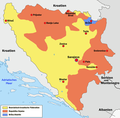
Fitxer:Bosnien-herzegowina 2-1225x1200.png

Mida d'aquesta previsualització: 612 × 600 píxels. Altres resolucions: 245 × 240 píxels | 490 × 480 píxels | 784 × 768 píxels | 1.225 × 1.200 píxels.
Fitxer original (1.225 × 1.200 píxels, mida del fitxer: 371 Ko, tipus MIME: image/png)
Historial del fitxer
Cliqueu una data/hora per veure el fitxer tal com era aleshores.
| Data/hora | Miniatura | Dimensions | Usuari/a | Comentari | |
|---|---|---|---|---|---|
| actual | 16:53, 30 nov 2007 |  | 1.225 × 1.200 (371 Ko) | Rottweiler | {{Information |Description=Politische Karte von Bosnien und Herzegowina mit den beiden Entitäten Föderation Bosnien und Herzegowina und Republika Srpska sowie dem Brčko-Distrikt.<br> <b>Urheber:</b> wolpertinger 15:34, 14. |
Ús del fitxer
La pàgina següent utilitza aquest fitxer:
Ús global del fitxer
Utilització d'aquest fitxer en altres wikis:
- Utilització a bg.wikipedia.org
- Utilització a de.wikipedia.org
- Utilització a eo.wikipedia.org
- Utilització a frr.wikipedia.org
- Utilització a hu.wikipedia.org
- Utilització a nl.wikipedia.org
- Utilització a no.wikipedia.org
- Utilització a pt.wikipedia.org
- Utilització a rm.wikipedia.org
- Utilització a sh.wikipedia.org
- Utilització a tr.wikipedia.org
- Utilització a www.wikidata.org
