Fitxer:Carte des croisades avec participation des Français.png

Fitxer original (1.997 × 1.188 píxels, mida del fitxer: 1,65 Mo, tipus MIME: image/png)
| Aquest fitxer i la informació mostrada a continuació provenen del dipòsit multimèdia lliure Wikimedia Commons. |
Resum
| Descripció |
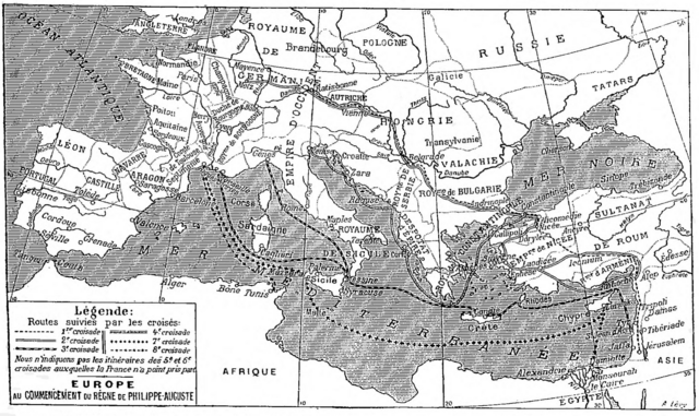
Deutsch: Karte der sechs mittelalterlichen Kreuzzüge, an denen die Franzosen teilgenommen haben, Larousse universel, 1922.
English: Map of the six medieval crusades in which the French participated, from Larousse universel, 1922.
Français : Carte des six croisades médiévales auxquelles les Français ont participé, Larousse universel en deux volumes, 1922. |
| Data | |
| Font | Scan from the Larousse 1922 by Nataraja-Shiva, also available on Gallica |
| Autor | Larousse |
Llicència
|
Aquest material està en domini públic als Estats Units i als altres països on el dret d'autor s'estén per 70 anys (o menys) després de la mort de l'autor.
| |
| Aquest fitxer està identificat com a lliure de restriccions conegudes sota la llei de drets d'autor, inclosos els drets veïns. | |
Historial del fitxer
Cliqueu una data/hora per veure el fitxer tal com era aleshores.
| Data/hora | Miniatura | Dimensions | Usuari/a | Comentari | |
|---|---|---|---|---|---|
| actual | 16:33, 3 des 2017 | | 1.997 × 1.188 (1,65 Mo) | Mélomène | Pologne, Tatars |
| 20:35, 25 nov 2016 |  | 1.997 × 1.188 (1,65 Mo) | Yann | much bigger size | |
| 12:34, 30 gen 2012 |  | 800 × 486 (485 Ko) | Spiridon Ion Cepleanu | Little changes on A. Levy's map since : « Westermann Grosser Atlas zur Weltgeschichte », 1985, ISBN 3-14-100919-8, « DTV Atlas zur Weltgeschichte », 1987, ISBN 2-7242-3596-7, & « Putzger historischer Weltatlas Cornelsen » 1990, ISBN 3-464-0017 | |
| 16:57, 18 gen 2005 |  | 982 × 597 (179 Ko) | Shizhao | from fr |
Ús del fitxer
No hi ha pàgines que utilitzin aquest fitxer.
Ús global del fitxer
Utilització d'aquest fitxer en altres wikis:
- Utilització a af.wikipedia.org
- Utilització a de.wikipedia.org
- Utilització a de.wiktionary.org
- Utilització a frr.wikipedia.org
- Utilització a fr.wikipedia.org
- Utilització a fr.wikibooks.org
- Utilització a gcr.wikipedia.org
- Utilització a ja.wikipedia.org
- Utilització a lmo.wikipedia.org
- Utilització a mn.wikipedia.org
- Utilització a mwl.wikipedia.org
- Utilització a oc.wikipedia.org
- Utilització a pl.wiktionary.org
- Utilització a pt.wikipedia.org
- Utilització a zh.wikipedia.org