Fitxer:Chagatai Khanate late 13th century locator map.svg

Fitxer original (fitxer SVG, nominalment 811 × 646 píxels, mida del fitxer: 278 Ko)
| Aquest fitxer i la informació mostrada a continuació provenen del dipòsit multimèdia lliure Wikimedia Commons. |
Resum
| Descripció |
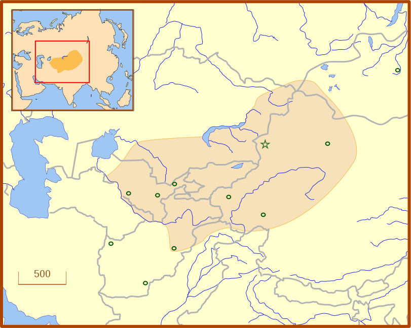
A locator map for the Chagatai Khanate in the late 13th century. The grey lines represent modern international borders. The blue represent rivers. This map uses a Lambert azimuthal equal-area projection. |
| Data | |
| Font | Treball propi |
| Autor | MapMaster |
| Altres versions | An English language version of the map. See also Image:Golden Horde 1389.svg |
References
- Barnes, Ian; Robert Hudson (1998) The History Atlas of Asia, MacMillan, p. 87.
- Barraclough, Geoffrey (1993) The Times Atlas of World History, 4th Edition, Hammond World Atlas Corporation, ISBN 0723005346, p. 127.
- Facts on File (2002) Historical Maps on File: Ringbound, Facts on File, 2nd Edition, ISBN 081604600X, p. 2.27 "Mongol Invasions of Russian, 12th-13th Centuries".
- Map of the Mongol Empire archive copy at the Wayback Machine, Los Angeles County Museum of Art, accessed 8 July 2008.
These references do not completely agree on the borders of the Khanate. The Facts on File map, for example, shows the borders that stretch to the Caspian Sea, unlike the other three. The eastern border is also slightly different from map to map, which likely reflects the fact that the borders of the eastern half, the nomadic half, were never formally set.
Llicència
- Sou lliure de:
- compartir – copiar, distribuir i comunicar públicament l'obra
- adaptar – fer-ne obres derivades
- Amb les condicions següents:
- reconeixement – Heu de donar la informació adequada sobre l'autor, proporcionar un enllaç a la llicència i indicar si s'han realitzat canvis. Podeu fer-ho amb qualsevol mitjà raonable, però de cap manera no suggereixi que l'autor us dóna suport o aprova l'ús que en feu.
Historial del fitxer
Cliqueu una data/hora per veure el fitxer tal com era aleshores.
| Data/hora | Miniatura | Dimensions | Usuari/a | Comentari | |
|---|---|---|---|---|---|
| actual | 05:07, 14 jul 2008 | | 811 × 646 (278 Ko) | MapMaster | Adde capital of Almalik |
| 06:19, 13 jul 2008 |  | 811 × 646 (277 Ko) | MapMaster | {{Information |Description=A locator map for the w:en:Chagatai Khanate in the late 13th century. |Source=self-made |Date=12 July 2008 |Author= MapMaster |Permission= |other_versions= }} |
Ús del fitxer
Les 2 pàgines següents utilitzen aquest fitxer:
Ús global del fitxer
Utilització d'aquest fitxer en altres wikis:
- Utilització a an.wikipedia.org
- Utilització a azb.wikipedia.org
- Utilització a ba.wikipedia.org
- Utilització a eo.wikipedia.org
- Utilització a es.wikipedia.org
- Utilització a fr.wikipedia.org
- Utilització a hy.wikipedia.org
- Utilització a ja.wikipedia.org
- Utilització a ka.wikipedia.org
- Utilització a kk.wikipedia.org
- Utilització a ko.wikipedia.org
- Utilització a nn.wikipedia.org
- Utilització a pt.wikipedia.org
- Utilització a ru.wikipedia.org
- Utilització a tr.wikipedia.org
- Utilització a tt.wikipedia.org
- Utilització a uk.wikipedia.org
- Utilització a uz.wikipedia.org
- Utilització a zh.wikipedia.org