Fitxer:China administrative.png

Fitxer original (857 × 699 píxels, mida del fitxer: 95 Ko, tipus MIME: image/png)
| Aquest fitxer i la informació mostrada a continuació provenen del dipòsit multimèdia lliure Wikimedia Commons. |
NOTE by original author
This map is no longer being updated. The newest version is in GIF format and is located at:

|
This map has been uploaded by Electionworld from en.wikipedia.org to enable the |
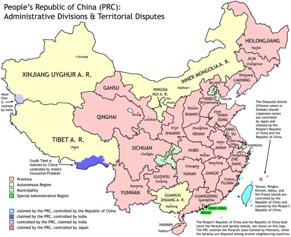
Administrative divisions of China. Made by Ran.
Features:
- Latest borders as of 2004. Qinghai-Gansu border readjustments are reflected; Sino-Russian agreement on the Amur-Ussuri delta is also (approximately) reflected.
- Disputed areas are given as neutral a treatment as possible.
The map was made based on a large-scale map of China made by woodhome and hunry of the XZQH forums.
Looking for translators!: If you want to translate the map into another language, here's a blank map that you can work with:
Alternatively, you can message me with the translated texts, and I will incorporate your translations for you and credit you for your work. (You don't have to translate the place names; I'll attempt to get them, as far as possible, from the Wikipedia in that language.) Same goes for any additions or corrections you'd like to make.
Translations have already been done for Spanish, German, Chinese (Simplified/Traditional), Japanese, French, Russian, Macedonian, Vietnamese, and Hebrew.
See also: en:Wikipedia:WikiProject Chinese provinces/Locator maps

|
S'autoritza la còpia, la distribució i la modificació d'aquest document sota els termes de la llicència de documentació lliure GNU versió 1.2 o qualsevol altra versió posterior que publiqui la Free Software Foundation; sense seccions invariants, ni textos de portada, ni textos de contraportada. S'inclou una còpia d'aquesta llicència en la secció titulada GNU Free Documentation License. |
| Aquest fitxer està subjecte a la llicència de Creative Commons Reconeixement i Compartir Igual 3.0 No adaptada. | ||
| ||
| Aquest avís de llicència s'ha afegit a aquest fitxer d'acord amb l'actualització de la llicència GFDL. |
Historial del fitxer
Cliqueu una data/hora per veure el fitxer tal com era aleshores.
| Data/hora | Miniatura | Dimensions | Usuari/a | Comentari | |
|---|---|---|---|---|---|
| actual | 21:43, 1 oct 2011 | | 857 × 699 (95 Ko) | Quigley | Southwest disputed area has its own name |
| 22:13, 26 ago 2007 |  | 857 × 699 (83 Ko) | Ran | {{Information |Description= |Source= |Date= |Author= |Permission= |other_versions= }} | |
| 15:52, 16 des 2006 |  | 857 × 699 (83 Ko) | Electionworld | {{ew|en|Ran}} Administrative divisions of China. Made by Ranr. Features: * Latest borders as of 2004. {{link|Qinghai}}-{{link|Gansu}} border readjustments are reflected; Sino-Russian agreement on the Amur-Ussuri delta is also (approxim |
Ús del fitxer
La pàgina següent utilitza aquest fitxer:
Ús global del fitxer
Utilització d'aquest fitxer en altres wikis:
- Utilització a avk.wikipedia.org
- Utilització a bg.wikipedia.org
- Utilització a blk.wikipedia.org
- Utilització a bs.wikipedia.org
- Utilització a cs.wikipedia.org
- Utilització a cu.wikipedia.org
- Utilització a el.wikipedia.org
- Utilització a en.wikipedia.org
- China
- User talk:Yug/Archive01
- File talk:India-locator-map-blank.svg
- User:Ahmadiskandarshah
- User:Palaeovia/sinology
- User:Jonny-mt/Gallery of current first-level administrative country subdivisions maps
- Template:PRC provinces big imagemap
- Outline of China
- Talk:Renminbi/Archive 1
- Talk:Chinese civilization/Archive 26
- User:Riley.W.Uhr/sandbox
- User:Falcaorib
- User:Centralismo
- User talk:FuzionEXA
- User:Sanskar shingare/sandbox
- Utilització a en.wikibooks.org
- Utilització a en.wikinews.org
- Utilització a eu.wikipedia.org
- Utilització a fa.wikipedia.org
- Utilització a hr.wikipedia.org
- Utilització a hy.wikipedia.org
- Utilització a incubator.wikimedia.org
- Utilització a lt.wikipedia.org
- Utilització a mn.wikipedia.org
- Utilització a ms.wikipedia.org
- Utilització a mwl.wikipedia.org
- Utilització a my.wikipedia.org
- Utilització a pam.wikipedia.org
- Utilització a pt.wikipedia.org
- Utilització a qu.wikipedia.org
- Utilització a ro.wikipedia.org
- Utilització a sd.wikipedia.org
- Utilització a shn.wikipedia.org
Vegeu més usos globals d'aquest fitxer.