Fitxer:City of London map 01.jpg
Mida d'aquesta previsualització: 773 × 600 píxels. Altres resolucions: 309 × 240 píxels | 619 × 480 píxels | 990 × 768 píxels | 1.280 × 993 píxels | 2.560 × 1.987 píxels | 4.778 × 3.708 píxels.
Fitxer original (4.778 × 3.708 píxels, mida del fitxer: 815 Ko, tipus MIME: image/jpeg)
| Aquest fitxer i la informació mostrada a continuació provenen del dipòsit multimèdia lliure Wikimedia Commons. |
Resum

|
File:City of London map 01.svg és una versió vectorial (SVG) d'aquest fitxer. En cas de ser millor, hauria de ser emprada en lloc d'aquesta imatge tramada.
File:City of London map 01.jpg → File:City of London map 01.svg
Per a més informació pel que fa als gràfics vectorials, llegiu la transició a SVG en Commons. També hi ha informació quant a la compatibilitat del MediaWiki amb les imatges SVG. |
 |
| Descripció |
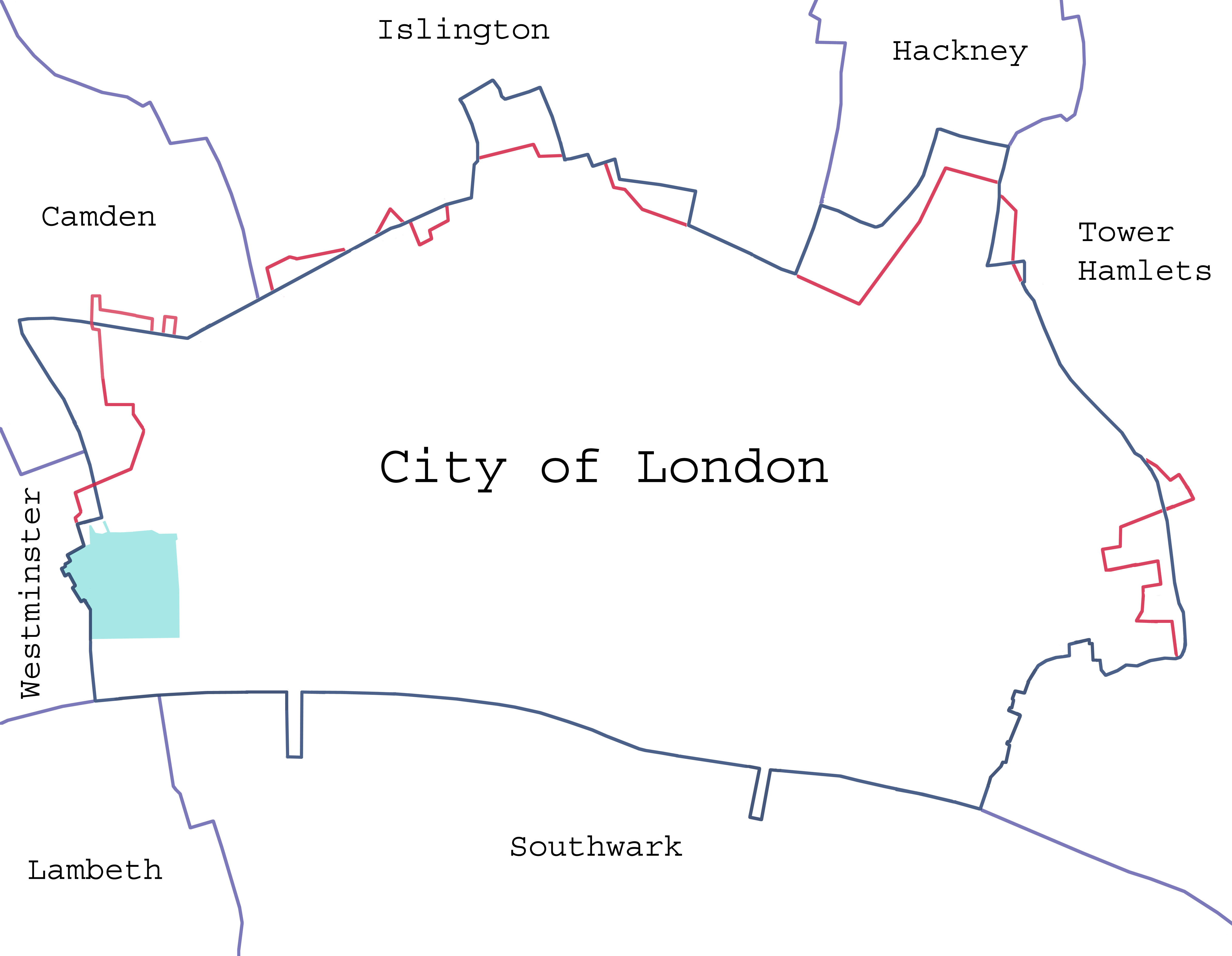
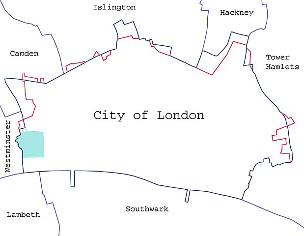
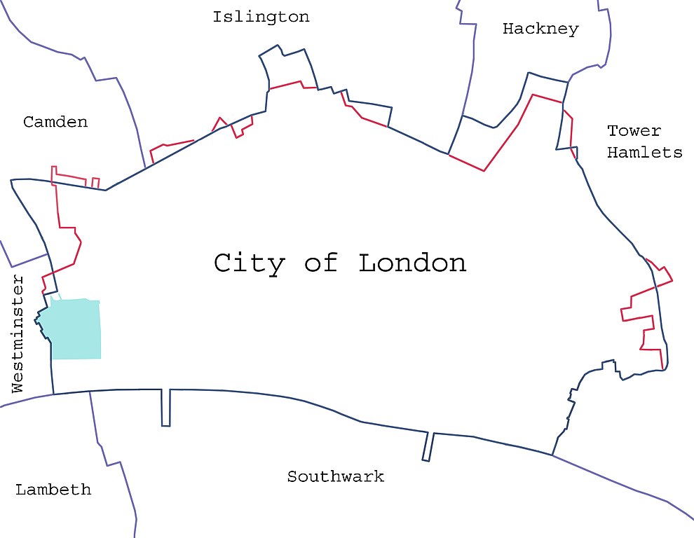
Català: Límits de la Ciutat de Londres en blau i els límits anteriors al 1993 en vermell.
Deutsch: Ausdehnung der City of London; die Grenze vor 1993 ist rot markiert, der Inner Temple und der Middle Temple grün.
English: Borders of the City of London, showing surrounding London boroughs and the pre-1994 boundary (where changed). The area covered by the Inner and Middle Temple is marked.
Español: Límites de la City.
Magyar: A City jelenlegi és 1993. előtti határai, szomszédos kerületei. Az Inner és Middle Temple által elfoglalt területeket is jelzi a térkép. English: Map of the en:City of London, showing surrounding London Boroughs and the pre-1993 boundary (where changed) in red. The area covered by the Inner and Middle Temples is shown in light green. |
| Data |
23 de gener de 2008 (original upload date) |
| Font | Treball propi (Original text: self-made) |
| Autor |
Dpaajones de la Viquipèdia en anglès |
| Permís (Com reutilitzar aquest fitxer) |
Yes; note that the map has been created with data from en:Ordnance Survey. |
Llicència
Dpaajones de la Viquipèdia en anglès, el titular dels drets d'autor d'aquest treball, el public sota les següents llicències:

|
S'autoritza la còpia, la distribució i la modificació d'aquest document sota els termes de la llicència de documentació lliure GNU versió 1.2 o qualsevol altra versió posterior que publiqui la Free Software Foundation; sense seccions invariants, ni textos de portada, ni textos de contraportada. S'inclou una còpia d'aquesta llicència en la secció titulada GNU Free Documentation License. |
Aquest fitxer està subjecte a la llicència Creative Commons Reconeixement i Compartir Igual 3.0 No adaptada, 2.5 Genèrica, 2.0 Genèrica i 1.0 Genèrica.
Reconeixement: Dpaajones de la Viquipèdia en anglès
- Sou lliure de:
- compartir – copiar, distribuir i comunicar públicament l'obra
- adaptar – fer-ne obres derivades
- Amb les condicions següents:
- reconeixement – Heu de donar la informació adequada sobre l'autor, proporcionar un enllaç a la llicència i indicar si s'han realitzat canvis. Podeu fer-ho amb qualsevol mitjà raonable, però de cap manera no suggereixi que l'autor us dóna suport o aprova l'ús que en feu.
- compartir igual – Si modifiqueu, transformeu, o generareu amb el material, haureu de distribuir les vostres contribucions sota una llicència similar o una de compatible com l'original
Podeu seleccionar la llicència que vulgueu.
Registre original de càrregues
La pàgina de descripció original era aquí. Els noms d'usuari a continuació es refereixen a en.wikipedia.
- 2008-01-24 14:20 Dpaajones 4778×3708×8 (834539 bytes) {{Information |Description=Map of the [[City of London]], showing surrounding London Boroughs and the pre-1993 boundary (where changed) in red. The area coverd by the Inner and Middle Temples is shown in light green. |Source=self-made |Date=January 2008 |
- 2008-01-24 14:16 Dpaajones 4778×3708×8 (834539 bytes) {{Information |Description=Map of the [[City of London]], showing surrounding London Boroughs and the pre-1993 boundary (where changed) in red. The area coverd by the Inner and Middle Temples is shown in light green. |Source=self-made |Date=January 2008 |
- 2008-01-23 22:38 Dpaajones 4778×3708×8 (828891 bytes) {{Information |Description=Map of the [[City of London]], showing surrounding London Boroughs and the pre-1993 boundary (where changed) |Source=self-made |Date=January 2008 |Location=City of London, London |Author=Mr David Philip Jones |Permission=yes |ot
Historial del fitxer
Cliqueu una data/hora per veure el fitxer tal com era aleshores.
| Data/hora | Miniatura | Dimensions | Usuari/a | Comentari | |
|---|---|---|---|---|---|
| actual | 00:44, 7 feb 2008 | | 4.778 × 3.708 (815 Ko) | Pacoperez6 | {{Information |Description={{en|Map of the en:City of London, showing surrounding London Boroughs and the pre-1993 boundary (where changed) in red. The area covered by the Inner and Middle Temples is shown in light green.}} |Source=Transferred from [ |
Ús del fitxer
La pàgina següent utilitza aquest fitxer:
Ús global del fitxer
Utilització d'aquest fitxer en altres wikis:
- Utilització a es.wikipedia.org
- Utilització a hu.wikipedia.org