Fitxer:Corinne Methodist Episcopal Church.jpg

Mida d'aquesta previsualització: 474 × 600 píxels. Altres resolucions: 190 × 240 píxels | 379 × 480 píxels | 607 × 768 píxels | 809 × 1.024 píxels | 1.618 × 2.048 píxels | 3.584 × 4.535 píxels.
Fitxer original (3.584 × 4.535 píxels, mida del fitxer: 1,7 Mo, tipus MIME: image/jpeg)
| Aquest fitxer i la informació mostrada a continuació provenen del dipòsit multimèdia lliure Wikimedia Commons. |
| Posició de la càmera | | Aquesta i altres imatges properes a: OpenStreetMap |
|---|
| Descripció |
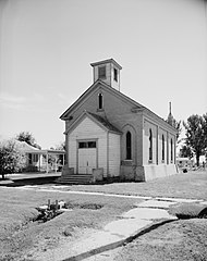
English: Front of the Corinne Methodist Episcopal Church, located at the intersection of Coronado and South 600 Streets in Corinne, Utah, United States. Built in 1870, it is listed on the National Register of Historic Places. |
|||||
| Data | ||||||
| Font | Library of Congress, Prints and Photograph Division HABS: UTAH,2-CORI,1-2 | |||||
| Autor | P. Kent Fairbanks | |||||
| Permís (Com reutilitzar aquest fitxer) |
|


|
This image is available from the United States Library of Congress's Prints and Photographs division
under the digital ID hhh.ut0007. This tag does not indicate the copyright status of the attached work. A normal copyright tag is still required. See Commons:Licensing.
|
Historial del fitxer
Cliqueu una data/hora per veure el fitxer tal com era aleshores.
| Data/hora | Miniatura | Dimensions | Usuari/a | Comentari | |
|---|---|---|---|---|---|
| actual | 10:50, 23 maig 2009 | | 3.584 × 4.535 (1,7 Mo) | Cropbot | upload cropped version, operated by User:Finavon. Summary: border cropped |
| 07:10, 23 maig 2009 |  | 4.038 × 4.993 (1,94 Mo) | Nyttend | {{Location|41|32|51|N|112|6|40|W}} {{Information |Description={{en|Front of the {{w|Corinne Methodist Episcopal Church}}, located at the intersection of Coronado and South 600 Streets in {{w|Corinne, Utah|Corinne}}, {{w|Utah}}, {{w|United States}}. Built |
Ús del fitxer
La pàgina següent utilitza aquest fitxer:
Ús global del fitxer
Utilització d'aquest fitxer en altres wikis:
- Utilització a ar.wikipedia.org
- Utilització a arz.wikipedia.org
- Utilització a azb.wikipedia.org
- Utilització a bg.wikipedia.org
- Utilització a ceb.wikipedia.org
- Utilització a ce.wikipedia.org
- Utilització a cy.wikipedia.org
- Utilització a en.wikipedia.org
- Utilització a eu.wikipedia.org
- Utilització a fa.wikipedia.org
- Utilització a fr.wikipedia.org
- Utilització a ht.wikipedia.org
- Utilització a it.wikipedia.org
- Utilització a lld.wikipedia.org
- Utilització a pl.wikipedia.org
- Utilització a pt.wikipedia.org
- Utilització a sh.wikipedia.org
- Utilització a sr.wikipedia.org
- Utilització a tt.wikipedia.org
- Utilització a uk.wikipedia.org
- Utilització a uz.wikipedia.org
- Utilització a www.wikidata.org
- Utilització a zh-min-nan.wikipedia.org