Fitxer:Cyprus 1973 ethnic neutral.svg

Mida d'aquesta previsualització PNG del fitxer SVG: 800 × 570 píxels. Altres resolucions: 320 × 228 píxels | 640 × 456 píxels | 1.024 × 729 píxels | 1.280 × 912 píxels | 2.560 × 1.824 píxels | 1.088 × 775 píxels.
Fitxer original (fitxer SVG, nominalment 1.088 × 775 píxels, mida del fitxer: 76 Ko)
| Aquest fitxer i la informació mostrada a continuació provenen del dipòsit multimèdia lliure Wikimedia Commons. |
Resum

Aquesta imatge vectorial ha estat creada amb Inkscape .
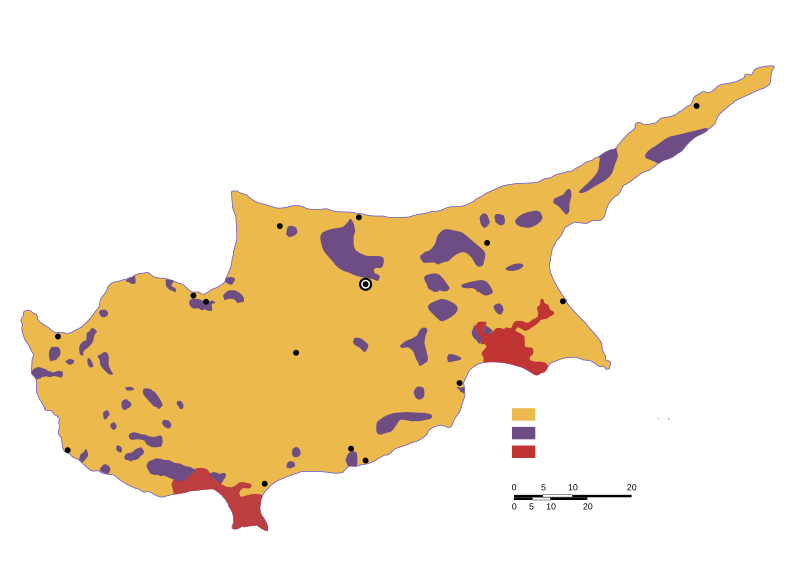
| Descripció | Ethnic distribution svg map of Cyprus in 1973, language neutral (check the source for town names and legend). |
| Data | |
| Font | Drawn by a map from the "Issues of the Middle East", CIA publication, at the Perry Castaneda colletion, Link: [1]. The yellow colour shows land with predominantly greek-cypriot population, while purple shows predominantly turkish-cypriot population (known in greece as "turkish-cypriot pockets"). British military bases are displayed in red colour. |
| Autor | Badseed |
| Permís (Com reutilitzar aquest fitxer) |
Public Domain |
| Altres versions |
|


![[1]](http://www.lib.utexas.edu/maps/europe/cyprus_ethnic_1973.jpg)
Llicència
| Jo, el titular del copyright d'aquesta obra, l'allibero al domini públic. Això s'aplica a tot el món. En alguns països això pot no ser legalment possible, en tal cas: Jo faig concessió a tothom del dret d'usar aquesta obra per a qualsevol propòsit, sense cap condició llevat d'aquelles requerides per la llei. |
Historial del fitxer
Cliqueu una data/hora per veure el fitxer tal com era aleshores.
| Data/hora | Miniatura | Dimensions | Usuari/a | Comentari | |
|---|---|---|---|---|---|
| actual | 22:31, 6 feb 2007 | | 1.088 × 775 (76 Ko) | Badseed | {{Information |Description=Ethnic distribution map of Cyprus in 1973. Labels in Greek. |Source=Drawn by a map from the "Issues of the Middle East", CIA publication, at the Perry Castaneda colletion, Link: [http://www.lib.utexas.edu/maps/europe/cyprus_eth |
Ús del fitxer
La pàgina següent utilitza aquest fitxer:
Ús global del fitxer
Utilització d'aquest fitxer en altres wikis:
- Utilització a am.wikipedia.org
- Utilització a ar.wikipedia.org
- Utilització a azb.wikipedia.org
- Utilització a az.wikipedia.org
- Utilització a be.wikipedia.org
- Utilització a bg.wikipedia.org
- Utilització a cs.wikipedia.org
- Utilització a en.wikipedia.org
- Utilització a eo.wikipedia.org
- Utilització a es.wikipedia.org
- Utilització a et.wikipedia.org
- Utilització a eu.wikipedia.org
- Utilització a fa.wikipedia.org
- Utilització a fi.wikipedia.org
- Utilització a fr.wikipedia.org
- Utilització a gl.wikipedia.org
- Utilització a hu.wikipedia.org
- Utilització a id.wikipedia.org
- Utilització a it.wikipedia.org
- Utilització a ja.wikipedia.org
- Utilització a ka.wikipedia.org
- Utilització a lv.wikipedia.org
- Utilització a nl.wikipedia.org
- Utilització a no.wikipedia.org
- Utilització a pnb.wikipedia.org
- Utilització a pt.wikipedia.org
- Utilització a ru.wikipedia.org
- Utilització a sr.wikipedia.org
- Utilització a sv.wikipedia.org
- Utilització a th.wikipedia.org
- Utilització a tr.wikipedia.org
- Utilització a tt.wikipedia.org
- Utilització a ur.wikipedia.org
- Utilització a uz.wikipedia.org
- Utilització a vi.wikipedia.org
- Utilització a www.wikidata.org
- Utilització a zh.wikipedia.org