Fitxer:East-Hem 050ad.jpg

Fitxer original (3.240 × 1.903 píxels, mida del fitxer: 722 Ko, tipus MIME: image/jpeg)
| Aquest fitxer i la informació mostrada a continuació provenen del dipòsit multimèdia lliure Wikimedia Commons. |

|
Aquesta imatge (de tipus historical map) s'hauria de tornar a crear utilitzant gràfics vectorials com ara un fitxer SVG. Això té diversos avantatges; en trobareu més informació a Commons:Media for cleanup. Si ja disposeu d'una versió d'aquesta imatge en format SVG, us preguem que la pengeu; després, reemplaceu aquesta plantilla amb la plantilla {{Vector version available|nom nou de la imatge.svg}} en aquesta imatge.
|


Resum
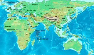
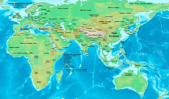
| Descripció | Eastern Hemisphere in 050 AD. |
| Font | Treball propi (For reference information, see the Map Source References section below.) |
| Autor | Thomas Lessman (Contact!) |
| Permís (Com reutilitzar aquest fitxer) |
Jo, el titular dels drets d'autor d'aquest treball, el public sota la següent llicència: Aquest fitxer està subjecte a la llicència de Creative Commons Reconeixement i Compartir Igual 3.0 No adaptada.
|
| Altres versions | East-Hem_050ad.jpg file history on Wikipedia. |
Map Summary
Original Source URL: http://www.thomaslessman.com/History/images/East-Hem_050ad.jpg.
This map of the Eastern Hemisphere in 050 AD was created by Thomas Lessman, based on information from the sources listed below. This map is free for educational use (see Permission info above). When using this map, please mention that it is available for free at www.WorldHistoryMaps.info.
Map Source References
- Remember, sources often conflict with each other. This map is only as accurate as the information that is available to me. To report any errors or to help further this work, please click here, or email Thomas Lessman at talessman@yis.us
References for information contained in this map:
1. Borders of Europe are mostly derived from the www.Euratlas.com maps of Europe in 001 AD archive copy at the Wayback Machine and from their map of Europe in 100 AD archive copy at the Wayback Machine.
2. Borders of Asian countries are derive from the following sources:
- a - The DK Atlas of World History, 2000 Edition; map of The World in 1 CE, (Pages 42-43) was used for information on several Asian borders in this map.
- b - Korean borders derive from this map of Korea_001.png made by Wikipedia User:Historiographer.
3. Some info also derive from Wikimedia's map of the World_in_50_CE.
4. Much of the information in this map was cross-checked with Bruce Gordon's Regnal Chronologies.
Other Maps by Thomas Lessman
| Maps of the eastern hemisphere showing history
Bold dates are available on Wikimedia or Wikipedia. | ||
| Primeval | ||
| Ancient
|
·| 600 BC | 550 BC | 527 BC | 500 BC |
400 BC | ·| 1 AD | 50 AD | 100 AD | 200 AD | 300 AD | | |
| Medieval |
·| 500 AD | 565 AD | 600 AD | 700 AD | | |
| Modern |
·| 1500 AD | · * For historical maps of the whole world, | |
Historial del fitxer
Cliqueu una data/hora per veure el fitxer tal com era aleshores.
| Data/hora | Miniatura | Dimensions | Usuari/a | Comentari | |
|---|---|---|---|---|---|
| actual | 17:53, 9 maig 2008 | | 3.240 × 1.903 (722 Ko) | Talessman | {{Information |Description=Eastern Hemisphere in 050 AD |Source=self-made |Author=Thomas Lessman |Permission={{self|cc-by-sa-3.0}} }} |
Ús del fitxer
Les 2 pàgines següents utilitzen aquest fitxer:
Ús global del fitxer
Utilització d'aquest fitxer en altres wikis:
- Utilització a ar.wikipedia.org
- Utilització a bs.wikipedia.org
- Utilització a en.wikipedia.org
- Utilització a es.wikipedia.org
- Utilització a fa.wikipedia.org
- Utilització a fr.wikipedia.org
- Utilització a gl.wikipedia.org
- Utilització a hu.wikipedia.org
- Utilització a inh.wikipedia.org
- Utilització a ja.wikipedia.org
- Utilització a mk.wikipedia.org
- Utilització a pl.wikipedia.org
- Utilització a pnb.wikipedia.org
- Utilització a ro.wikipedia.org
- Utilització a rue.wikipedia.org
- Utilització a ru.wikipedia.org
- Utilització a sh.wikipedia.org
- Utilització a simple.wikipedia.org
- Utilització a si.wikipedia.org
- Utilització a sv.wikipedia.org
- Utilització a sw.wikipedia.org
- Utilització a ta.wikipedia.org
- Utilització a tl.wikipedia.org
- Utilització a ur.wikipedia.org
- Utilització a vi.wikipedia.org
- Utilització a zh.wikipedia.org