Fitxer:Ethnographic-map-Thrace-1912.jpg

Fitxer original (3.520 × 2.080 píxels, mida del fitxer: 6,01 Mo, tipus MIME: image/jpeg)
| Aquest fitxer i la informació mostrada a continuació provenen del dipòsit multimèdia lliure Wikimedia Commons. |
Resum
| Descripció |
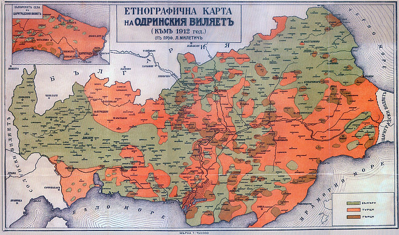
Български: Етнографска карта на Одрински вилает (Източна и Западна Тракия) на Любомир Милетич от 1861. English: Ethnographic map of Edirne Villayet (en:Eastern Thrace and en:Western Thrace) in 1912 by en:Lyubomir Miletich. |
| Font | Разорението на тракийските българи през 1913 година, Българска академия на науките, София, Държавна печатница, 1918 г. |
| Autor | bg:Любомир Милетич, en:Lyubomir Miletich (1863-1937) |
Llicència
|
Aquest material està en domini públic als Estats Units i als altres països on el dret d'autor s'estén per 70 anys (o menys) després de la mort de l'autor.
| |
| Aquest fitxer està identificat com a lliure de restriccions conegudes sota la llei de drets d'autor, inclosos els drets veïns. | |
Historial del fitxer
Cliqueu una data/hora per veure el fitxer tal com era aleshores.
| Data/hora | Miniatura | Dimensions | Usuari/a | Comentari | |
|---|---|---|---|---|---|
| actual | 21:07, 20 gen 2013 | | 3.520 × 2.080 (6,01 Mo) | Slick-o-bot | Bot: convert to a non-interlaced jpeg image (see bugzilla:17645) |
| 12:55, 22 març 2008 |  | 3.520 × 2.080 (4,98 Mo) | Пакко | {{Information |Description= |Source= |Date= |Author= |Permission= |other_versions= }} | |
| 11:12, 8 gen 2008 |  | 3.520 × 2.080 (2,17 Mo) | Мико | {{Information |Description={{bg|Етнографска карта на Одрински вилает (Източна и Западна Тракия на [[:bg:Любомир Милетич|Люб� |
Ús del fitxer
La pàgina següent utilitza aquest fitxer:
Ús global del fitxer
Utilització d'aquest fitxer en altres wikis:
- Utilització a ast.wikipedia.org
- Utilització a ba.wikipedia.org
- Utilització a be-tarask.wikipedia.org
- Utilització a be.wikipedia.org
- Utilització a bg.wikipedia.org
- Utilització a cs.wikipedia.org
- Utilització a de.wikipedia.org
- Utilització a en.wikipedia.org
- Utilització a es.wikipedia.org
- Utilització a fr.wikipedia.org
- Utilització a hy.wikipedia.org
- Utilització a it.wikipedia.org
- Utilització a ka.wikipedia.org
- Utilització a mk.wikipedia.org
- Utilització a myv.wikipedia.org
- Utilització a oc.wikipedia.org
- Utilització a ru.wikipedia.org
- Utilització a sq.wikipedia.org
- Utilització a tr.wikipedia.org
- Utilització a uk.wikipedia.org