Fitxer:Europe 814.svg

Fitxer original (fitxer SVG, nominalment 1.399 × 919 píxels, mida del fitxer: 3,4 Mo)
| Aquest fitxer i la informació mostrada a continuació provenen del dipòsit multimèdia lliure Wikimedia Commons. |
Resum
| Descripció |
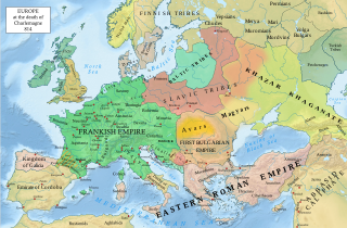
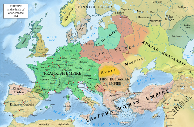
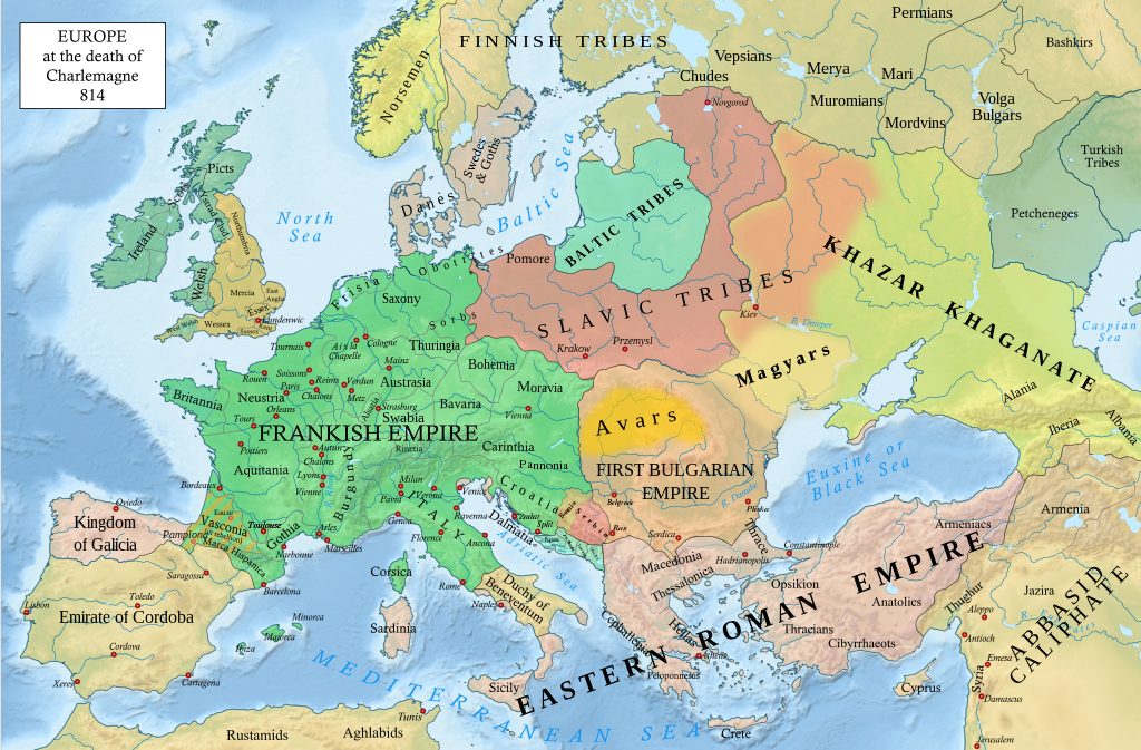
English: An svg version of File:Europe 814.jpg with corrections.
List of corrections:
|
| Data | |
| Font | "The Public Schools Historical Atlas" by Charles Colbeck. Longmans, Green; New York; London; Bombay. 1905. |
| Autor | Hel-hama |
| Altres versions |
|


_en.png)
.png)
.jpg)
Llicència
- Sou lliure de:
- compartir – copiar, distribuir i comunicar públicament l'obra
- adaptar – fer-ne obres derivades
- Amb les condicions següents:
- reconeixement – Heu de donar la informació adequada sobre l'autor, proporcionar un enllaç a la llicència i indicar si s'han realitzat canvis. Podeu fer-ho amb qualsevol mitjà raonable, però de cap manera no suggereixi que l'autor us dóna suport o aprova l'ús que en feu.
- compartir igual – Si modifiqueu, transformeu, o generareu amb el material, haureu de distribuir les vostres contribucions sota una llicència similar o una de compatible com l'original
Aquest fitxer és en el domini públic en els Estats Units. Això és aplicable a obres dels EUA on el copyright ha expirat, sovint perquè la seva primera publicació va ser abans de l'1 de gener de 1929. Vegeu aquesta pàgina per a més detalls.
|
 | |
 |
Podria ser que aquesta imatge no estigui en el domini públic fora dels Estats Units (especialment on no s'aplica la regla del termini més curt per obres dels EUA, com Canada, la Xina continental (no a Hong Kong ni Macau), Alemanya, Mèxic i Suïssa). El creador i any de publicació són informació essencial i s'han de proporcionar. Vegeu Viquipèdia:Drets d'autor per a més detalls.
|
_(St_Edwards_Crown).svg)
|
This file is licensed under the Open Government Licence version 1.0 (OGL v1.0).
|
|---|---|
|
You are free to:
See the Open Government Licence page on Meta-Wiki for more information.
|
This work is in the public domain in India because its term of copyright has expired.
The Indian Copyright Act applies in India to works first published in India. According to the Indian Copyright Act, 1957, as amended up to Act No. 27 of 2012 (Chapter V, Section 25):
|
 |
Historial del fitxer
Cliqueu una data/hora per veure el fitxer tal com era aleshores.
| Data/hora | Miniatura | Dimensions | Usuari/a | Comentari | |
|---|---|---|---|---|---|
| actual | 22:05, 8 gen 2023 | | 1.399 × 919 (3,4 Mo) | Miki Filigranski | correction of Bosnian border, which was a separate land according to modern scholarship, contested but never completelly under Serbian or Croatian control |
| 23:32, 29 nov 2022 |  | 1.399 × 919 (3,39 Mo) | Gyalu22 | Added Avar ethnic territory, see Bulgarians_and_Slavs_VI-VII_century.png. Also extended Magyar ethnic territory to Bessarabia | |
| 12:26, 1 nov 2022 |  | 1.399 × 919 (3,38 Mo) | Miki Filigranski | Reverted to version as of 07:20, 31 July 2022 (UTC) | |
| 06:47, 3 ago 2022 |  | 1.399 × 919 (3,38 Mo) | Bernd21t | (resum d'edició eliminat) | |
| 09:20, 31 jul 2022 |  | 1.399 × 919 (3,38 Mo) | Miki Filigranski | Reverted to version as of 16:51, 27 March 2022 (UTC) | |
| 07:13, 18 jul 2022 |  | 1.399 × 919 (3,38 Mo) | Ionelen | Reverted to version as of 19:41, 13 April 2022 (UTC) | |
| 09:41, 12 jul 2022 |  | 1.399 × 919 (3,38 Mo) | Ahmet Q. | Reverted to version as of 16:51, 27 March 2022 (UTC) | |
| 21:41, 13 abr 2022 |  | 1.399 × 919 (3,38 Mo) | Wojsław12 | Reverted to version as of 11:43, 14 January 2022 (UTC) | |
| 18:51, 27 març 2022 |  | 1.399 × 919 (3,38 Mo) | Silverije | Reverted to version as of 12:43, 1 June 2021 (UTC) | |
| 13:43, 14 gen 2022 |  | 1.399 × 919 (3,38 Mo) | TómasdeAquino2 | Corrected POV issues of blocked sock of Crovata Miki Filigranski |
Ús del fitxer
La pàgina següent utilitza aquest fitxer:
Ús global del fitxer
Utilització d'aquest fitxer en altres wikis:
- Utilització a af.wikipedia.org
- Utilització a ar.wikipedia.org
- Utilització a arz.wikipedia.org
- Utilització a bg.wikipedia.org
- Utilització a bn.wikipedia.org
- Utilització a cs.wikipedia.org
- Utilització a cy.wikipedia.org
- Utilització a de.wikipedia.org
- Utilització a el.wikipedia.org
- Utilització a en.wikipedia.org
- Charlemagne
- History of Europe
- Vikings
- 814
- History of Estonia
- Bulgars
- Principality of Serbia (early medieval)
- Saare County
- Early Middle Ages
- Kvenland
- Askold and Dir
- Duchy of Benevento
- Portal:Estonia
- Franks
- Višeslav of Serbia
- History of Christian thought on persecution and tolerance
- Borna (duke)
- Vlastimir
- Arab–Khazar wars
- Duchy of Gascony
- Muslim conquest of Sicily
- Prosigoj
- Rus' people
- Early Slavs
- Radoslav of Serbia
- Barbarian kingdoms
- Agriculture in the Middle Ages
- Gersuinda
- User:Falcaorib/Medieval Empires (800-1000 AD)
- User:Falcaorib/Europe
- Utilització a en.wikibooks.org
Vegeu més usos globals d'aquest fitxer.