Fitxer:French Mandate for Syria and the Lebanon map fr.svg

Mida d'aquesta previsualització PNG del fitxer SVG: 725 × 599 píxels. Altres resolucions: 290 × 240 píxels | 581 × 480 píxels | 929 × 768 píxels | 1.239 × 1.024 píxels | 2.478 × 2.048 píxels | 922 × 762 píxels.
Fitxer original (fitxer SVG, nominalment 922 × 762 píxels, mida del fitxer: 251 Ko)
| Aquest fitxer i la informació mostrada a continuació provenen del dipòsit multimèdia lliure Wikimedia Commons. |
Resum
| Descripció |
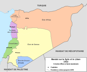
English: Map of French Mandate for Syria and the Lebanon and the states created in 1922, in French. Sources:
Français : Carte de la Syrie mandataire en 1922. |
| Data | |
| Font | Treball propi, based on File:Syria, administrative divisions - de - colored.svg |
| Autor | Don-kun, TUBS, NordNordWest |
| Altres versions |
[]
|


Llicència
Jo, el titular dels drets d'autor d'aquest treball, el public sota les següents llicències:

|
S'autoritza la còpia, la distribució i la modificació d'aquest document sota els termes de la llicència de documentació lliure GNU versió 1.2 o qualsevol altra versió posterior que publiqui la Free Software Foundation; sense seccions invariants, ni textos de portada, ni textos de contraportada. S'inclou una còpia d'aquesta llicència en la secció titulada GNU Free Documentation License. |
Aquest fitxer està subjecte a la llicència de Creative Commons Reconeixement 3.0 No adaptada.
- Sou lliure de:
- compartir – copiar, distribuir i comunicar públicament l'obra
- adaptar – fer-ne obres derivades
- Amb les condicions següents:
- reconeixement – Heu de donar la informació adequada sobre l'autor, proporcionar un enllaç a la llicència i indicar si s'han realitzat canvis. Podeu fer-ho amb qualsevol mitjà raonable, però de cap manera no suggereixi que l'autor us dóna suport o aprova l'ús que en feu.
Podeu seleccionar la llicència que vulgueu.
Historial del fitxer
Cliqueu una data/hora per veure el fitxer tal com era aleshores.
| Data/hora | Miniatura | Dimensions | Usuari/a | Comentari | |
|---|---|---|---|---|---|
| actual | 17:34, 4 feb 2013 | | 922 × 762 (251 Ko) | Don-kun | fix border to palestine, source: http://en.wikisource.org/wiki/Franco-British_Convention_on_Certain_Points_Connected_with_the_Mandates_for_Syria_and_the_Lebanon,_Palestine_and_Mesopotamia |
| 20:44, 30 gen 2013 |  | 922 × 762 (248 Ko) | Don-kun | minus ahistorical lakes (and so all waterbodies) | |
| 08:45, 28 gen 2013 |  | 922 × 762 (282 Ko) | Rémih | fixes of french legend | |
| 22:13, 27 gen 2013 |  | 922 × 762 (282 Ko) | Don-kun | fixes | |
| 23:45, 26 gen 2013 |  | 922 × 762 (282 Ko) | Don-kun | {{Information |Description ={{en|1=Map of French Mandate for Syria and the Lebanon and the states created in 1922, in French.}} |Source ={{own}}, based on File:Syria, administrative divisions - de - colored.svg |Author =[[User:D... |
Ús del fitxer
No hi ha pàgines que utilitzin aquest fitxer.
Ús global del fitxer
Utilització d'aquest fitxer en altres wikis:
- Utilització a de.wikipedia.org
- Utilització a fr.wikipedia.org
- Syrie
- Accords Sykes-Picot
- Liste des colonies françaises
- Histoire de la Syrie
- Légion étrangère
- Sandjak d'Alexandrette
- État du Hatay
- Territoire des Alaouites
- État d'Alep
- État de Damas
- Bataille de Khan Mayssaloun
- Chrétiens d'Orient
- Grand Liban
- État des Druzes
- Partition de l'Empire ottoman
- Grande famine du Mont-Liban
- Utilisateur:Exp JC/Brouillon
- Fédéralisation de la Syrie
- Accord Paulet-Newcombe
- Utilització a nn.wikipedia.org
- Utilització a sv.wikipedia.org