Fitxer:Goethals Map of the Gatun Dam.jpg

Mida d'aquesta previsualització: 800 × 583 píxels. Altres resolucions: 320 × 233 píxels | 640 × 467 píxels | 1.045 × 762 píxels.
Fitxer original (1.045 × 762 píxels, mida del fitxer: 128 Ko, tipus MIME: image/jpeg)
| Aquest fitxer i la informació mostrada a continuació provenen del dipòsit multimèdia lliure Wikimedia Commons. |
Resum
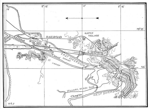
This map from the construction of the Panama Canal illustrates the north end of the canal, showing the area around the Gatun locks and Gatun Dam. The proposed lock and dam structures are shown superposed over the waterways existing at the end of the French attempt to build a sea-level canal there. North is to the left.
From An address to the National Geographic Society by George Washington Goethals, February 10, 1911.
Llicència
Aquest fitxer és en el domini públic en els Estats Units. Això és aplicable a obres dels EUA on el copyright ha expirat, sovint perquè la seva primera publicació va ser abans de l'1 de gener de 1929. Vegeu aquesta pàgina per a més detalls.
|
 | |
 |
Podria ser que aquesta imatge no estigui en el domini públic fora dels Estats Units (especialment on no s'aplica la regla del termini més curt per obres dels EUA, com Canada, la Xina continental (no a Hong Kong ni Macau), Alemanya, Mèxic i Suïssa). El creador i any de publicació són informació essencial i s'han de proporcionar. Vegeu Viquipèdia:Drets d'autor per a més detalls.
|
Historial del fitxer
Cliqueu una data/hora per veure el fitxer tal com era aleshores.
| Data/hora | Miniatura | Dimensions | Usuari/a | Comentari | |
|---|---|---|---|---|---|
| actual | 19:42, 29 oct 2005 | | 1.045 × 762 (128 Ko) | Johantheghost | This map from the construction of the Panama Canal illustrates the north end of the canal, showing the area around the Gatun locks and Gatun Dam. The proposed lock and dam structures are shown superposed |
Ús del fitxer
La pàgina següent utilitza aquest fitxer:
Ús global del fitxer
Utilització d'aquest fitxer en altres wikis:
- Utilització a cs.wikipedia.org
- Utilització a de.wikipedia.org
- Utilització a en.wikipedia.org
- Utilització a es.wikipedia.org
- Utilització a fr.wikipedia.org