Fitxer:GreaterItalia.jpg

Mida d'aquesta previsualització: 728 × 599 píxels. Altres resolucions: 292 × 240 píxels | 583 × 480 píxels | 759 × 625 píxels.
Fitxer original (759 × 625 píxels, mida del fitxer: 201 Ko, tipus MIME: image/jpeg)
| Aquest fitxer i la informació mostrada a continuació provenen del dipòsit multimèdia lliure Wikimedia Commons. |
Resum
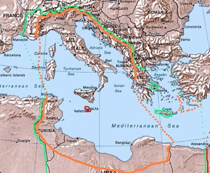
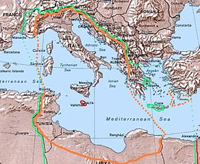
| Descripció | Map of the 1940 project "Imperial Italia", inside the orange line and dots, in Europe and North Africa. Self-made (I have based my work on the original Commons Image:Mediterranean Relief.jpg, licensed PD-USGov). The green line and dots show the biggest extension of Italian control in the Mediterranean sea in november 1942 (while the red shows the British controlled areas, like Malta). |
| Data | |
| Font | Treball propi |
| Autor | Brunodambrosio |
| Altres versions |
File:ItalianMareNostrum.jpg File:ProgettoImperoItaliano.jpg |
Llicència
| Jo, el titular del copyright d'aquesta obra, l'allibero al domini públic. Això s'aplica a tot el món. En alguns països això pot no ser legalment possible, en tal cas: Jo faig concessió a tothom del dret d'usar aquesta obra per a qualsevol propòsit, sense cap condició llevat d'aquelles requerides per la llei. |
Historial del fitxer
Cliqueu una data/hora per veure el fitxer tal com era aleshores.
| Data/hora | Miniatura | Dimensions | Usuari/a | Comentari | |
|---|---|---|---|---|---|
| actual | 05:44, 19 abr 2008 | | 759 × 625 (201 Ko) | Brunodambrosio | {{Information |Description=Map of the 1940 project "Greater Italia", inside the orange line and dots, in Europe and North Africa. Self-made (I have based my work on the original Commons Image:Mediterranean Relief.jpg, licensed PD-USGov). The green line an |
Ús del fitxer
La pàgina següent utilitza aquest fitxer:
Ús global del fitxer
Utilització d'aquest fitxer en altres wikis:
- Utilització a ar.wikipedia.org
- Utilització a ast.wikipedia.org
- Utilització a be.wikipedia.org
- Utilització a en.wikipedia.org
- Utilització a eo.wikipedia.org
- Utilització a es.wikipedia.org
- Utilització a eu.wikipedia.org
- Utilització a fa.wikipedia.org
- Utilització a fi.wikipedia.org
- Utilització a fr.wikipedia.org
- Utilització a hu.wikipedia.org
- Utilització a id.wikipedia.org
- Utilització a it.wikipedia.org
- Utilització a ka.wikipedia.org
- Utilització a lt.wikipedia.org
- Utilització a os.wikipedia.org
- Utilització a pt.wikipedia.org
- Utilització a ru.wikipedia.org
- Utilització a sh.wikipedia.org
- Utilització a sq.wikipedia.org
- Utilització a sr.wikipedia.org
- Utilització a sv.wikipedia.org
- Utilització a uk.wikipedia.org