Fitxer:Greaterboston2.png
No hi ha cap versió amb una resolució més gran.
Greaterboston2.png (500 × 500 píxels, mida del fitxer: 68 Ko, tipus MIME: image/png)
| Aquest fitxer i la informació mostrada a continuació provenen del dipòsit multimèdia lliure Wikimedia Commons. |
Resum
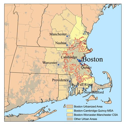
| Descripció | This is a map of the Greater Boston Metro area I made using U.S. Census Bureau data as of 2006. The light gray shading indicates urbanized areas with Greater Boston as defined by urbanized areas outlined in red. The Metropolitan Statistical Area is shown in yellow. The Combined Statistical Area includes the MSA plus those counties that are partially shaded. The Providence metro area was added to the Boston CSA in 2005. |
| Data | 10 de gener de 2007 (original upload date) |
| Font | No machine-readable source provided. Own work assumed (based on copyright claims). |
| Autor | No machine-readable author provided. Kmusser assumed (based on copyright claims). |
Llicència
Jo, el titular dels drets d'autor d'aquest treball, el public sota la següent llicència:
Aquest fitxer està publicat sota la llicència de Creative Commons Reconeixement i Compartir Igual 2.5 Genèrica.
- Sou lliure de:
- compartir – copiar, distribuir i comunicar públicament l'obra
- adaptar – fer-ne obres derivades
- Amb les condicions següents:
- reconeixement – Heu de donar la informació adequada sobre l'autor, proporcionar un enllaç a la llicència i indicar si s'han realitzat canvis. Podeu fer-ho amb qualsevol mitjà raonable, però de cap manera no suggereixi que l'autor us dóna suport o aprova l'ús que en feu.
- compartir igual – Si modifiqueu, transformeu, o generareu amb el material, haureu de distribuir les vostres contribucions sota una llicència similar o una de compatible com l'original
Historial del fitxer
Cliqueu una data/hora per veure el fitxer tal com era aleshores.
| Data/hora | Miniatura | Dimensions | Usuari/a | Comentari | |
|---|---|---|---|---|---|
| actual | 00:14, 17 gen 2007 | | 500 × 500 (68 Ko) | Kmusser | increased contrast |
| 19:22, 10 gen 2007 |  | 500 × 500 (64 Ko) | Kmusser | == Summary == This is a map of the Greater Boston Metro area I made using U.S. Census Bureau data as of 2006. The light gray shading indicates urbanized areas with Greater Boston as defined by urb |
Ús del fitxer
La pàgina següent utilitza aquest fitxer:
Ús global del fitxer
Utilització d'aquest fitxer en altres wikis:
- Utilització a ar.wikipedia.org
- Utilització a ast.wikipedia.org
- Utilització a azb.wikipedia.org
- Utilització a de.wikipedia.org
- Utilització a en.wikipedia.org
- Utilització a eo.wikipedia.org
- Utilització a es.wikipedia.org
- Utilització a fa.wikipedia.org
- Utilització a fr.wikipedia.org
- Utilització a gl.wikipedia.org
- Utilització a it.wikivoyage.org
- Utilització a ko.wikipedia.org
- Utilització a pl.wikipedia.org
- Utilització a ru.wikipedia.org
- Utilització a sv.wikipedia.org
- Utilització a ta.wikipedia.org
- Utilització a uk.wikipedia.org
- Utilització a ur.wikipedia.org
- Utilització a vi.wikipedia.org
- Utilització a www.wikidata.org
- Utilització a zh.wikipedia.org