Fitxer:Greenland ice sheet AMSL thickness map-en.png

Mida d'aquesta previsualització: 351 × 599 píxels. Altres resolucions: 141 × 240 píxels | 281 × 480 píxels | 450 × 768 píxels | 1.056 × 1.801 píxels.
Fitxer original (1.056 × 1.801 píxels, mida del fitxer: 1 Mo, tipus MIME: image/png)
| Aquest fitxer i la informació mostrada a continuació provenen del dipòsit multimèdia lliure Wikimedia Commons. |
Resum
| Descripció |
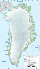
English: Map in English of Greenland ice sheet thickness. Thickness over 10 m above bedrock and mean sea level.
Français : Carte en anglais de l'épaisseur de l'inlandsis du Groenland. Épaisseur supérieure à 10 m au-dessus de la surface rocheuse et du niveau moyen des mers.
|
||
| Data | |||
| Font |
Treball propi
|
||
| Autor | Eric Gaba (Sting - fr:Sting) | ||
| Permís (Com reutilitzar aquest fitxer) |
|
||
| Altres versions |
[]
|


| Posició de la càmera | | Aquesta i altres imatges properes a: OpenStreetMap |
|---|
Llicència
Eric Gaba (Wikimedia Commons user Sting), el titular dels drets d'autor d'aquest treball, el public sota la següent llicència:
Aquest fitxer està subjecte a la llicència de Creative Commons Reconeixement i Compartir Igual 3.0 No adaptada.
Reconeixement: Eric Gaba (Wikimedia Commons user Sting)
- Sou lliure de:
- compartir – copiar, distribuir i comunicar públicament l'obra
- adaptar – fer-ne obres derivades
- Amb les condicions següents:
- reconeixement – Heu de donar la informació adequada sobre l'autor, proporcionar un enllaç a la llicència i indicar si s'han realitzat canvis. Podeu fer-ho amb qualsevol mitjà raonable, però de cap manera no suggereixi que l'autor us dóna suport o aprova l'ús que en feu.
- compartir igual – Si modifiqueu, transformeu, o generareu amb el material, haureu de distribuir les vostres contribucions sota una llicència similar o una de compatible com l'original
Historial del fitxer
Cliqueu una data/hora per veure el fitxer tal com era aleshores.
| Data/hora | Miniatura | Dimensions | Usuari/a | Comentari | |
|---|---|---|---|---|---|
| actual | 22:12, 13 feb 2011 | | 1.056 × 1.801 (1 Mo) | Ras67 | cropped |
| 20:56, 3 gen 2011 |  | 1.060 × 1.805 (1,17 Mo) | Sting | == {{int:filedesc}} == {{Information |Description={{en|Map in English of Greenland ice sheet thickness. Thickness over 10 m above bedrock and mean sea level.}} {{fr|Carte en anglais de l'épaisseur de l'[[:fr:Inlandsis du Groen |
Ús del fitxer
Les 2 pàgines següents utilitzen aquest fitxer:
Ús global del fitxer
Utilització d'aquest fitxer en altres wikis:
- Utilització a ar.wikipedia.org
- Utilització a ast.wikipedia.org
- Utilització a az.wikipedia.org
- Utilització a be-tarask.wikipedia.org
- Utilització a be.wikipedia.org
- Utilització a bn.wikipedia.org
- Utilització a cs.wikipedia.org
- Utilització a da.wikipedia.org
- Utilització a en.wikipedia.org
- Utilització a es.wikipedia.org
- Utilització a fr.wikipedia.org
- Utilització a gl.wikipedia.org
- Utilització a he.wikipedia.org
- Utilització a hu.wikipedia.org
- Utilització a hy.wikipedia.org
- Utilització a id.wikipedia.org
- Utilització a it.wikipedia.org
- Utilització a ja.wikipedia.org
- Utilització a ka.wikipedia.org
- Utilització a mn.wikipedia.org
- Utilització a ms.wikipedia.org
- Utilització a nl.wikipedia.org
- Utilització a pl.wikipedia.org
- Utilització a ru.wikipedia.org
- Utilització a sd.wikipedia.org
- Utilització a to.wikipedia.org
- Utilització a uk.wikipedia.org
- Utilització a uz.wikipedia.org
Vegeu més usos globals d'aquest fitxer.