Fitxer:Ground Deformation from Chilean Volcanic Eruption Shown by Satellite Radar Image.png

Fitxer original (2.881 × 1.729 píxels, mida del fitxer: 13,81 Mo, tipus MIME: image/png)
| Aquest fitxer i la informació mostrada a continuació provenen del dipòsit multimèdia lliure Wikimedia Commons. |
Resum
| Descripció |
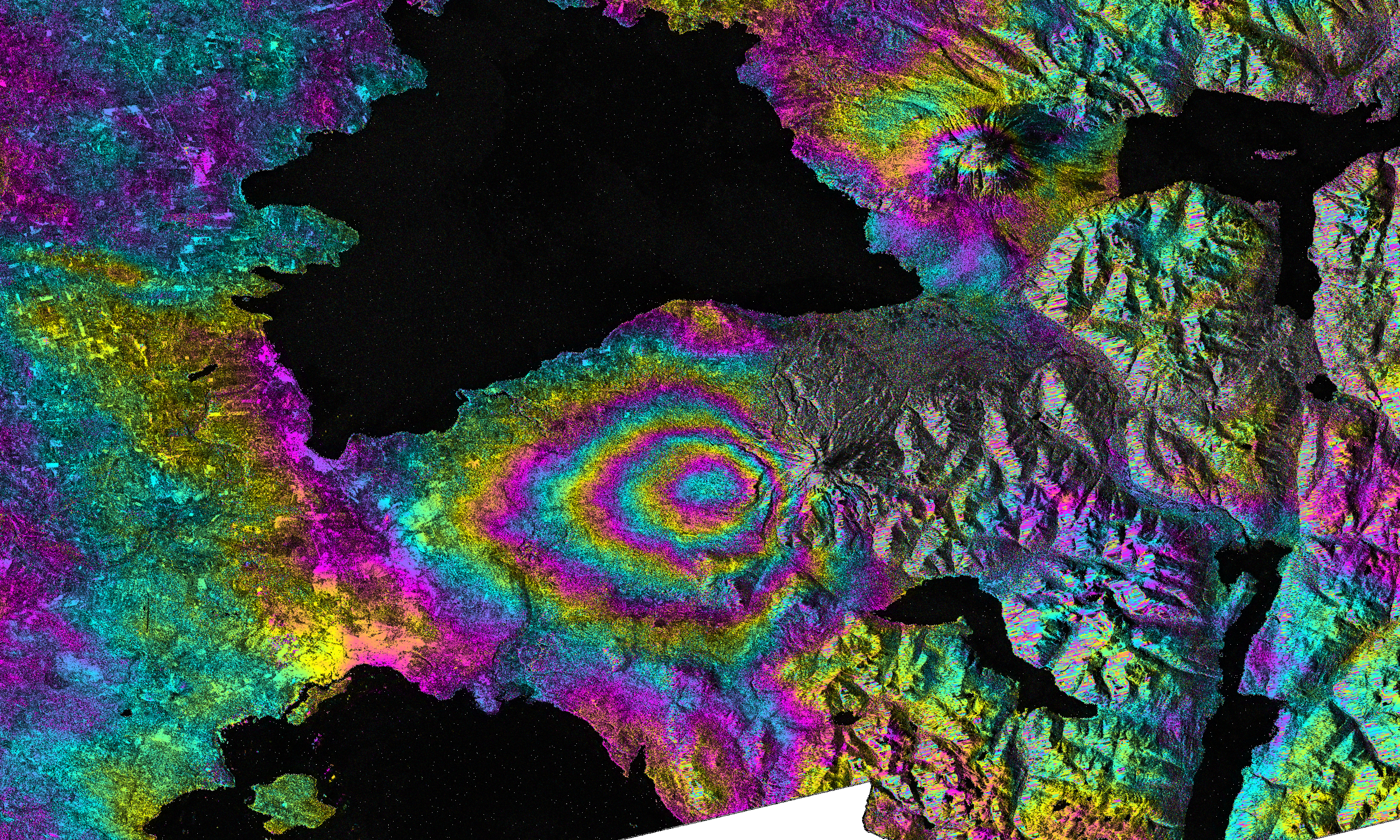
English: On April 22-23, 2015, significant explosive eruptions occurred at Calbuco volcano, Chile. This was the first eruptive activity at Calbuco since 1972. A satellite interferometric synthetic aperture radar image was created by Paul Lundgren of NASA's Jet Propulsion Laboratory in Pasadena, Calif., using data acquired from the European Space Agency's (ESA) Sentinel-1 radar satellite's C-SAR sensor. This image depicts the relative deformation of Earth's surface using radar data acquired on April 14 and 26, 2015, that span the eruption. The concentric, "leaf-shaped" pattern of fringes (color cycles) lies to the west of Calbuco volcano and represents subsidence of the ground surface due to deflation of a buried magma reservoir. The black areas in the image represent water, to the north lies Lago Llanquihue and to the south lies Puerto Montt Bay (Pacific Ocean).
Image Details Target: Earth Spacecraft: Sentinel-1A Instrument: C-SAR Sensor Views: 132 Full-Res TIFF: PIA11434.tif (11.55 MB) Full-Res JPG: PIA11434.jpg (1.66 MB) Image credit: ESA/NASA/JPL-Caltech |
| Data | 2015-04-22-23 |
| Font | http://photojournal.jpl.nasa.gov/archive/PIA11434_filt_fine.3alks_9rlks_S12.unw.geo.png |
| Autor | Image credit: ESA/NASA/JPL-Caltech |
Llicència

|
This image contains data from a satellite in the Copernicus Programme, such as Sentinel-1, Sentinel-2 or Sentinel-3. Attribution is required when using this image.
Reconeixement: Contains modified Copernicus Sentinel data 2015
The use of Copernicus Sentinel Data is regulated under EU law (Commission Delegated Regulation (EU) No 1159/2013 and Regulation (EU) No 377/2014). Relevant excerpts:
Free access shall be given to GMES dedicated data [...] made available through GMES dissemination platforms [...].
Access to GMES dedicated data [...] shall be given for the purpose of the following use in so far as it is lawful:
GMES dedicated data [...] may be used worldwide without limitations in time.
GMES dedicated data and GMES service information are provided to users without any express or implied warranty, including as regards quality and suitability for any purpose. |
Historial del fitxer
Cliqueu una data/hora per veure el fitxer tal com era aleshores.
| Data/hora | Miniatura | Dimensions | Usuari/a | Comentari | |
|---|---|---|---|---|---|
| actual | 07:42, 4 maig 2015 | | 2.881 × 1.729 (13,81 Mo) | LuisArmandoRasteletti | User created page with UploadWizard |
Ús del fitxer
La pàgina següent utilitza aquest fitxer:
Ús global del fitxer
Utilització d'aquest fitxer en altres wikis:
- Utilització a ar.wikipedia.org
- Utilització a bg.wikipedia.org
- Utilització a cs.wikipedia.org
- Utilització a en.wikipedia.org
- Utilització a fa.wikipedia.org
- Utilització a he.wikipedia.org
- Utilització a www.wikidata.org