Fitxer:Inner german border diagram 1960s.png

Mida d'aquesta previsualització: 800 × 562 píxels. Altres resolucions: 320 × 225 píxels | 640 × 450 píxels | 1.024 × 720 píxels | 1.280 × 900 píxels | 1.596 × 1.122 píxels.
Fitxer original (1.596 × 1.122 píxels, mida del fitxer: 335 Ko, tipus MIME: image/png)
| Aquest fitxer i la informació mostrada a continuació provenen del dipòsit multimèdia lliure Wikimedia Commons. |
| Descripció |
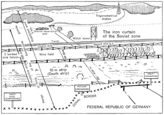
English: Extract from an English-language leaflet given to visitors to the en:Inner German border by West German border guards in Lower Saxony, depicting the configuration of the border as it was in the early 1960s. Schematic diagram depicting the inner German border system of the 1960s as seen from West Germany. The border cuts across a road which formerly linked east and west. In the foreground, Federal Republic of Germany territory with signposts marking the zonal border and a road ending in a gate just before the zonal border; a variable distance behind the zonal border, in Soviet zone territory, there is first a fence, then a 20- to 200-metre cleared area, beginning with the 10-metre death strip; after the cleared area, there is barbed-wire fencing, then a mine field with a width of 10–30 metres, parts of it covered with wires, then more barbed-wire fencing, a 6-metre control strip, a trench, then another strip of territory including a ground observation post and a watchtower behind the trench, bounded by a dotted line and a barrier on the road which resumes its course on the eastern side, beyond the mine field. Deeper in East German territory, there are woods and a trigonometrical station. The width of the 500-metre protective strip is marked by a double-headed arrow extending from the westernmost end of the death strip to the easternmost end of the territory containing the ground observation post and watch tower. The firing range of the guards extends from the zonal border itself to just beyond the end of the territory containing the ground observation post and watchtower. The prohibited zone is marked as having a width of 5 kilometres, also using a double-headed arrow, extending from the zonal border in the foreground to a line behind the trigonometrical station. The whole border arrangement is marked as "The iron curtain of the Soviet zone". |
|||
| Data | Early 1960s | |||
| Font | Scan of original leaflet | |||
| Autor | Ministerium für Bundesangelegenheiten, Vertriebene und Flüchtlinge | |||
| Permís (Com reutilitzar aquest fitxer) |
|

Historial del fitxer
Cliqueu una data/hora per veure el fitxer tal com era aleshores.
| Data/hora | Miniatura | Dimensions | Usuari/a | Comentari | |
|---|---|---|---|---|---|
| actual | 22:15, 7 ago 2009 | | 1.596 × 1.122 (335 Ko) | ChrisO | {{Information |Description={{en|1=Extract from an English-language leaflet given to visitors to the en:Inner German border by West German border guards in Lower Saxony, depicting the configuration of the border as it was in the early 1960s.}} |Source |
Ús del fitxer
La pàgina següent utilitza aquest fitxer:
Ús global del fitxer
Utilització d'aquest fitxer en altres wikis:
- Utilització a ar.wikipedia.org
- Utilització a el.wikipedia.org
- Utilització a en.wikipedia.org
- Utilització a pl.wikipedia.org