Fitxer:IrishSeaReliefMap.jpg
Mida d'aquesta previsualització: 415 × 600 píxels. Altres resolucions: 166 × 240 píxels | 332 × 480 píxels | 531 × 768 píxels | 1.043 × 1.507 píxels.
Fitxer original (1.043 × 1.507 píxels, mida del fitxer: 2,15 Mo, tipus MIME: image/jpeg)
| Aquest fitxer i la informació mostrada a continuació provenen del dipòsit multimèdia lliure Wikimedia Commons. |
Resum
| Descripció |
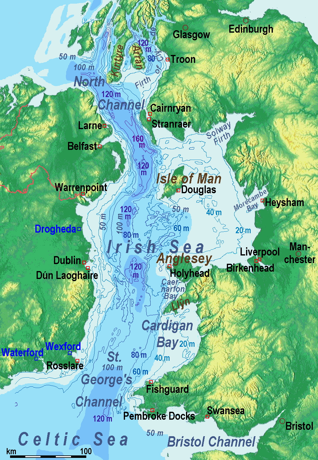
A map of the en:Irish Sea. Major ports shown with red marks. freight-only ports in blue. |
| Data | old map 2005-08-03; new map 2014-05-11 |
| Font | old map: http://www.vindaloo.uklinux.net/jjg/code/tmutils.html-> new map: Maps for Free and Treball propi |
| Autor | old one Users SFC9394, Seabhcan on en.wikipedia, new one Ulamm (talk) 01:37, 11 May 2014 (UTC) |
| Permís (Com reutilitzar aquest fitxer) |
old map: from http://www.vindaloo.uklinux.net/jjg/code/tmutils.html. Released to public domain by creator. |
| Altres versions |
History of the od map
Old map riginally from en.wikipedia; description page is (was) here
- 14:22, 20 March 2006 SFC9394 461×561 (85,860 bytes) (Corrected locations for Cairnryan & Stranraer)
- 10:56, 25 November 2005 Seabhcan 461×561 (73,292 bytes) (Removed the ports of Heysham and Fleetwood, to which en:User:Robdurbar took offence. )
- 16:23, 3 August 2005 Seabhcan 461×561 (95,162 bytes) (Added channel names)
- 15:50, 3 August 2005 Seabhcan 461×561 (93,219 bytes) (A map of the en:Irish Sea Major ports shown in red. freight only ports in blue. from [1]. Released to public domain by creator.)
Sources of information for the new map
- internal report Nr. 174 of the National Oceanography Centre (Liverpool)
- http://www.dcenr.gov.ie (Department of Communications, Energy and Natural Resources) -> IOSEA4Annex–Master–r02–Fiinal.pdf (Fourth Strategic Environmental Assessment for Oil and Gas ACtivity in Irelands Offshore Waters) -> figures 2.1 & 2.2a
Llicència
Jo, el titular dels drets d'autor d'aquest treball, el public sota la següent llicència:
Aquest fitxer està subjecte a la llicència de Creative Commons Reconeixement i Compartir Igual 3.0 No adaptada.
- Sou lliure de:
- compartir – copiar, distribuir i comunicar públicament l'obra
- adaptar – fer-ne obres derivades
- Amb les condicions següents:
- reconeixement – Heu de donar la informació adequada sobre l'autor, proporcionar un enllaç a la llicència i indicar si s'han realitzat canvis. Podeu fer-ho amb qualsevol mitjà raonable, però de cap manera no suggereixi que l'autor us dóna suport o aprova l'ús que en feu.
- compartir igual – Si modifiqueu, transformeu, o generareu amb el material, haureu de distribuir les vostres contribucions sota una llicència similar o una de compatible com l'original
(Uploaded using CommonsHelper or PushForCommons)
Historial del fitxer
Cliqueu una data/hora per veure el fitxer tal com era aleshores.
| Data/hora | Miniatura | Dimensions | Usuari/a | Comentari | |
|---|---|---|---|---|---|
| actual | 13:42, 13 maig 2014 | | 1.043 × 1.507 (2,15 Mo) | Ulamm | optimized colour scale |
| 16:17, 12 maig 2014 |  | 1.043 × 1.507 (1,87 Mo) | Ulamm | more names, smaller letters | |
| 14:25, 11 maig 2014 |  | 1.043 × 1.449 (1,73 Mo) | Ulamm | depths and names of bays and inlets | |
| 12:56, 11 maig 2014 |  | 1.043 × 1.449 (1,71 Mo) | Ulamm | land colours lightened | |
| 04:22, 11 maig 2014 |  | 1.043 × 1.449 (1,7 Mo) | Ulamm | more ports | |
| 03:50, 11 maig 2014 |  | 1.043 × 1.449 (1,69 Mo) | Ulamm | completion outside the Irish Sea | |
| 03:39, 11 maig 2014 |  | 1.043 × 1.449 (1,68 Mo) | Ulamm | completely new map | |
| 11:01, 1 nov 2006 |  | 461 × 561 (84 Ko) | Korrigan | {{Information| |Description= A map of the en:Irish Sea Major ports shown in red. freight only ports in blue. |Source= |Date= |Author=Users SFC9394, Seabhcan on [http://en.wikipedia.org en.wikipedia] |Permiss |
Ús del fitxer
La pàgina següent utilitza aquest fitxer:
Ús global del fitxer
Utilització d'aquest fitxer en altres wikis:
- Utilització a af.wikipedia.org
- Utilització a an.wikipedia.org
- Utilització a ast.wikipedia.org
- Utilització a ba.wikipedia.org
- Utilització a be.wikipedia.org
- Utilització a bg.wikipedia.org
- Utilització a bn.wikipedia.org
- Utilització a br.wikipedia.org
- Utilització a cs.wikipedia.org
- Utilització a cv.wikipedia.org
- Utilització a cy.wikipedia.org
- Utilització a da.wikipedia.org
- Utilització a el.wikipedia.org
- Utilització a eo.wikipedia.org
- Utilització a es.wikipedia.org
- Utilització a eu.wikipedia.org
- Utilització a fa.wikipedia.org
- Utilització a fy.wikipedia.org
- Utilització a gl.wikipedia.org
- Utilització a gv.wikipedia.org
- Utilització a he.wikipedia.org
- Utilització a hu.wikipedia.org
- Utilització a hu.wiktionary.org
- Utilització a id.wikipedia.org
- Utilització a is.wikipedia.org
- Utilització a ka.wikipedia.org
- Utilització a kk.wikipedia.org
- Utilització a ko.wikipedia.org
- Utilització a ku.wikipedia.org
- Utilització a lmo.wikipedia.org
- Utilització a lt.wikipedia.org
Vegeu més usos globals d'aquest fitxer.