Fitxer:Italy c 1810-es.png

Mida d'aquesta previsualització: 415 × 600 píxels. Altres resolucions: 166 × 240 píxels | 332 × 480 píxels | 531 × 768 píxels | 1.249 × 1.805 píxels.
Fitxer original (1.249 × 1.805 píxels, mida del fitxer: 320 Ko, tipus MIME: image/png)
| Aquest fitxer i la informació mostrada a continuació provenen del dipòsit multimèdia lliure Wikimedia Commons. |
| Descripció |
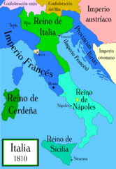
Political map of Italy in the years around 1810, during the Napoleonic era, created by MapMaster. This is a companion map to Image:Italy 1796.png and Image:Italy 1494_v2.png. Mapa político de Italia alrededor del año 1810, durante la era Napoleónica, creado por MapMaster (traducido por Aibdescalzo). Mapas relacionados: Image:Italy 1796.png y Image:Italy 1494_v2.png.
|
| Data | (UTC) |
| Font | |
| Autor |
|
| Altres versions |
[]
|


Jo, el titular dels drets d'autor d'aquest treball, el public sota la següent llicència:

|
S'autoritza la còpia, la distribució i la modificació d'aquest document sota els termes de la llicència de documentació lliure GNU versió 1.2 o qualsevol altra versió posterior que publiqui la Free Software Foundation; sense seccions invariants, ni textos de portada, ni textos de contraportada. S'inclou una còpia d'aquesta llicència en la secció titulada GNU Free Documentation License. |
| Aquest fitxer està subjecte a la llicència de Creative Commons Reconeixement i Compartir Igual 3.0 No adaptada. | ||
| ||
| Aquest avís de llicència s'ha afegit a aquest fitxer d'acord amb l'actualització de la llicència GFDL. |
Registre original de càrregues
This image is a derivative work of the following images:
- File:Italy_c_1810.png licensed with GFDL, GFDL/en
- 2006-10-19T04:01:10Z MapMaster 1251x1814 (394066 Bytes) Further improvements to bring it into line with [[:Image:Italy 1796.png]]
- 2006-10-13T12:41:34Z MapMaster 1251x1814 (412811 Bytes) Map was slightly improved.
- 2006-10-13T12:00:36Z MapMaster 1265x1816 (411395 Bytes) Political map of Italy in the years around 1810, during the Napoleonic era, created by MapMaster.
Uploaded with derivativeFX
Historial del fitxer
Cliqueu una data/hora per veure el fitxer tal com era aleshores.
| Data/hora | Miniatura | Dimensions | Usuari/a | Comentari | |
|---|---|---|---|---|---|
| actual | 03:15, 11 gen 2009 | | 1.249 × 1.805 (320 Ko) | VanKleinen | {{Information |Description=Political map of Italy in the years around 1810, during the Napoleonic era, created by MapMaster. This is a companion map to Image:Italy 1796.png and Image:Italy 1494_v2.png. ---- Mapa político de Italia alrededor |
Ús del fitxer
La pàgina següent utilitza aquest fitxer:
Ús global del fitxer
Utilització d'aquest fitxer en altres wikis:
- Utilització a es.wikipedia.org
- Utilització a gl.wikipedia.org
- Utilització a it.wikipedia.org