Fitxer:Jansson-Visscher map.jpg
Mida d'aquesta previsualització: 712 × 600 píxels. Altres resolucions: 285 × 240 píxels | 570 × 480 píxels | 912 × 768 píxels | 1.215 × 1.024 píxels | 1.728 × 1.456 píxels.
Fitxer original (1.728 × 1.456 píxels, mida del fitxer: 2,67 Mo, tipus MIME: image/jpeg)
| Aquest fitxer i la informació mostrada a continuació provenen del dipòsit multimèdia lliure Wikimedia Commons. |
Resum
| Descripció |
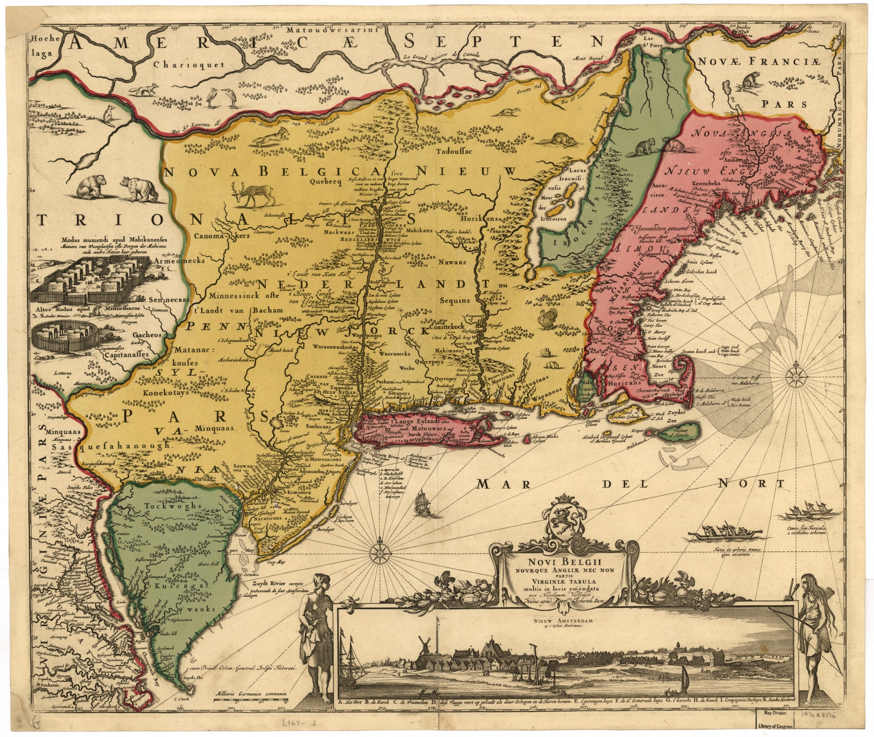
Nederlands: De Jansson-Visscher kaart van Nieuw Nederland, eerste uitgave 1650. Links afbeeldingen van Indiaanse dorpen, rechts onder een visoog profiel van de stad Nieuw Amsterdam. Deze kaart is een latere ingekleurde versie die latere grenzen met Nieuw Engeland weergeeft. Zie ook Image:Map-Novi Belgii Novæque Angliæ (Amsterdam, 1685).jpg.
Legenda: English: The Jansson-Visscher map of New Netherland, first published in 1650. On the left are illustrations of typical Indian villages, while the lower right inset shows a picture of New Amsterdam. This copy is a later recoloration to reflect later borders with New England. See also Image:Map-Novi Belgii Novæque Angliæ (Amsterdam, 1685).jpg.
Legend in Dutch: Español: El mapa Jansson-Visscher del noreste de América, publicado por primera vez por Van der Donck |
||
| Data | |||
| Font |
|
||
| Autor | Nicolaus Visscher (Novi Belgii Novaeque Angliae Nec Non Pennsylvaniae et Partis Virginiae Tabula multis in locis emendate per Nicolaum Visscher nunc apud Peter Schenk Iun:) | ||
| Altres versions |
|


.jpg)

.jpg)


.png)
Llicència
|
Aquest material està en domini públic als Estats Units i als altres països on el dret d'autor s'estén per 100 anys (o menys) després de la mort de l'autor. Aquesta obra es troba en el domini públic als Estats Units d'Amèrica per haver estat publicada abans de l'1 de gener de 1929. | |
| Aquest fitxer està identificat com a lliure de restriccions conegudes sota la llei de drets d'autor, inclosos els drets veïns. | |
Historial del fitxer
Cliqueu una data/hora per veure el fitxer tal com era aleshores.
| Data/hora | Miniatura | Dimensions | Usuari/a | Comentari | |
|---|---|---|---|---|---|
| actual | 16:07, 15 abr 2018 | | 1.728 × 1.456 (2,67 Mo) | Hansmuller | Reverted to version as of 12:50, 30 July 2012 (UTC) |
| 14:57, 30 jul 2012 |  | 496 × 418 (69 Ko) | Joopr132 | Reverted to version as of 15:38, 3 December 2005 | |
| 14:50, 30 jul 2012 |  | 1.728 × 1.456 (2,67 Mo) | Joopr132 | Higher Resolution | |
| 17:38, 3 des 2005 |  | 496 × 418 (69 Ko) | Laurascudder | The Jansson-Visscher map of en:New Netherland, first published in 1650. On the left are illustrations of typical indian villiages of several types, while the lower right inset shows a picture of New Amsterdam. See also [[:Image:Map-Novi Belgii Novæ |
Ús del fitxer
No hi ha pàgines que utilitzin aquest fitxer.
Ús global del fitxer
Utilització d'aquest fitxer en altres wikis:
- Utilització a azb.wikipedia.org
- Utilització a en.wikipedia.org