Fitxer:K2 by Montgomery.jpg
Mida d'aquesta previsualització: 800 × 380 píxels. Altres resolucions: 320 × 152 píxels | 820 × 389 píxels.
Fitxer original (820 × 389 píxels, mida del fitxer: 129 Ko, tipus MIME: image/jpeg)
| Aquest fitxer i la informació mostrada a continuació provenen del dipòsit multimèdia lliure Wikimedia Commons. |
Resum
| Descripció |
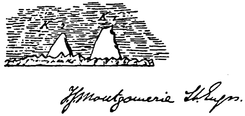
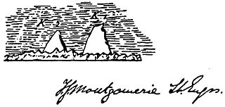
English: Sketch by Thomas Montgomerie made during his exploration of the Karakoram. He noted two prominent peaks, labelling them K1 and K2. K1 is now known as Masherbrum, but K2 was never formally named; Montgomerie had inadvertently named the world's second highest mountain. |
| Data | |
| Font | Scanned from K2 - The Story of the Savage Mountain by Jim Curran, ISBN 0340660074 |
| Autor | Thomas Montgomerie (1830-1878) |
| Permís (Com reutilitzar aquest fitxer) |
Public domain |
Llicència
|
Aquest material està en domini públic als Estats Units i als altres països on el dret d'autor s'estén per 70 anys (o menys) després de la mort de l'autor. | |
| Aquest fitxer està identificat com a lliure de restriccions conegudes sota la llei de drets d'autor, inclosos els drets veïns. | |
Historial del fitxer
Cliqueu una data/hora per veure el fitxer tal com era aleshores.
| Data/hora | Miniatura | Dimensions | Usuari/a | Comentari | |
|---|---|---|---|---|---|
| actual | 21:52, 7 ago 2008 | | 820 × 389 (129 Ko) | Iain99 | {{Information |Description=Sketch by Thomas Montgomerie made during his exploration of the Karakoram. He noted two prominent peaks, labelling them K1 and K2. K1 is now known as (Masherbrum), |
Ús del fitxer
Les 2 pàgines següents utilitzen aquest fitxer:
Ús global del fitxer
Utilització d'aquest fitxer en altres wikis:
- Utilització a ast.wikipedia.org
- Utilització a bn.wikipedia.org
- Utilització a de.wikipedia.org
- Utilització a el.wikipedia.org
- Utilització a en.wikipedia.org
- Utilització a en.wiktionary.org
- Utilització a es.wikipedia.org
- Utilització a fr.wikipedia.org
- Utilització a hr.wikipedia.org
- Utilització a id.wikipedia.org
- Utilització a it.wikipedia.org
- Utilització a ja.wikipedia.org
- Utilització a kn.wikipedia.org
- Utilització a nl.wikipedia.org
- Utilització a nn.wikipedia.org
- Utilització a pl.wikipedia.org
- Utilització a pt.wikipedia.org
- Utilització a sh.wikipedia.org
- Utilització a simple.wikipedia.org
- Utilització a sr.wikipedia.org
- Utilització a tr.wikipedia.org
- Utilització a vec.wikipedia.org
- Utilització a www.wikidata.org