Fitxer:LanguageMap-Kikongo-Kituba.png

Mida d'aquesta previsualització: 800 × 529 píxels. Altres resolucions: 320 × 212 píxels | 640 × 423 píxels | 1.024 × 677 píxels | 1.420 × 939 píxels.
Fitxer original (1.420 × 939 píxels, mida del fitxer: 89 Ko, tipus MIME: image/png)
| Aquest fitxer i la informació mostrada a continuació provenen del dipòsit multimèdia lliure Wikimedia Commons. |
Resum
| Descripció |
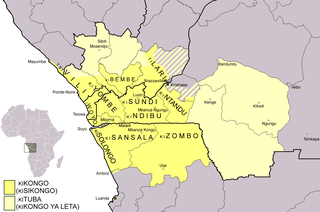
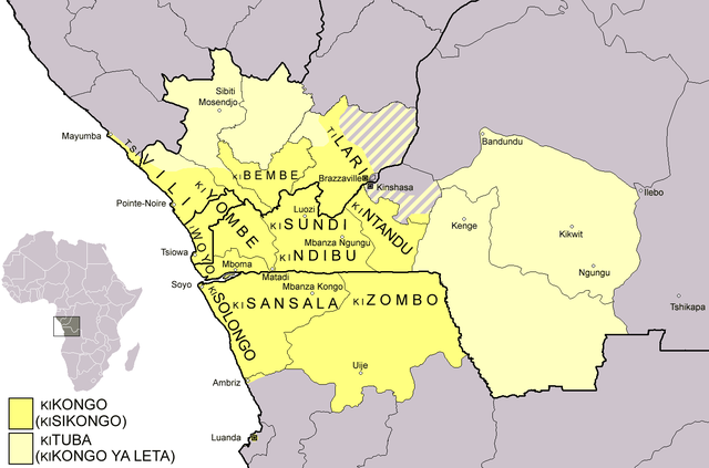
Dialect map of Kikongo. Dark yellow areas are inhabited mainly by first language speakers of the various dialects/languages of Kikongo. Names of some dialects/languages are written on the map. Pale yellow areas are inhabited by first and second language speakers of Kituba (a.k.a. Kikongo ya Leta), which is the lingua franca in the area. Kituba is understood by most speakers of Kikongo. Map drawn by Risto Kupsala. Details are based on the language maps of Ethnologue and several other sources. |
| Data | 2 d'abril de 2006 (original upload date) |
| Font | No machine-readable source provided. Own work assumed (based on copyright claims). |
| Autor | No machine-readable author provided. Rasulo~commonswiki assumed (based on copyright claims). |
Llicència
| Jo, el titular del copyright d'aquesta obra, l'allibero al domini públic. Això s'aplica a tot el món. En alguns països això pot no ser legalment possible, en tal cas: Jo faig concessió a tothom del dret d'usar aquesta obra per a qualsevol propòsit, sense cap condició llevat d'aquelles requerides per la llei. |
Historial del fitxer
Cliqueu una data/hora per veure el fitxer tal com era aleshores.
| Data/hora | Miniatura | Dimensions | Usuari/a | Comentari | |
|---|---|---|---|---|---|
| actual | 02:37, 25 feb 2021 | | 1.420 × 939 (89 Ko) | Somebody040404 | Reverted to version as of 10:10, 29 March 2018 (UTC) |
| 02:26, 25 feb 2021 |  | 1.420 × 939 (82 Ko) | Somebody040404 | ||
| 12:10, 29 març 2018 |  | 1.420 × 939 (89 Ko) | Maphobbyist | South Sudan border | |
| 23:24, 20 des 2007 |  | 1.420 × 939 (60 Ko) | Rasulo~commonswiki | Dialect map of Kikongo. Dark yellow areas are inhabited mainly by native speakers of the various dialects/languages of Ki(si)kongo. Names of some dialects/languages are written on the map. Pale yellow areas are inhabited by first and second language speak | |
| 14:12, 22 jul 2006 |  | 718 × 518 (26 Ko) | Rasulo~commonswiki | ||
| 11:49, 2 abr 2006 |  | 571 × 471 (20 Ko) | Rasulo~commonswiki | Dialect map of Kikongo Dark green areas are inhabited mainly by first language speakers of the various dialects/languages of Kikongo. Names of some dialects/languages are written on the map. Light green areas are inhabited by first and second language spe |
Ús del fitxer
Les 2 pàgines següents utilitzen aquest fitxer:
Ús global del fitxer
Utilització d'aquest fitxer en altres wikis:
- Utilització a af.wikipedia.org
- Utilització a ar.wikipedia.org
- Utilització a ast.wikipedia.org
- Utilització a az.wiktionary.org
- Utilització a bn.wikipedia.org
- Utilització a cs.wikipedia.org
- Utilització a da.wikipedia.org
- Utilització a de.wikipedia.org
- Utilització a en.wikipedia.org
- Utilització a eo.wikipedia.org
- Utilització a es.wikipedia.org
- Utilització a eu.wikipedia.org
- Utilització a fi.wikipedia.org
- Utilització a frr.wikipedia.org
- Utilització a fr.wikipedia.org
- Utilització a fr.wiktionary.org
Vegeu més usos globals d'aquest fitxer.