Fitxer:Le Mont St. Michel, Normandy, France. View, bilingual description and map.jpg

Mida d'aquesta previsualització: 800 × 596 píxels. Altres resolucions: 320 × 238 píxels | 640 × 477 píxels | 1.024 × 763 píxels | 1.280 × 953 píxels | 2.560 × 1.907 píxels | 3.797 × 2.828 píxels.
Fitxer original (3.797 × 2.828 píxels, mida del fitxer: 3,11 Mo, tipus MIME: image/jpeg)
| Aquest fitxer i la informació mostrada a continuació provenen del dipòsit multimèdia lliure Wikimedia Commons. |
Resum
| Descripció |
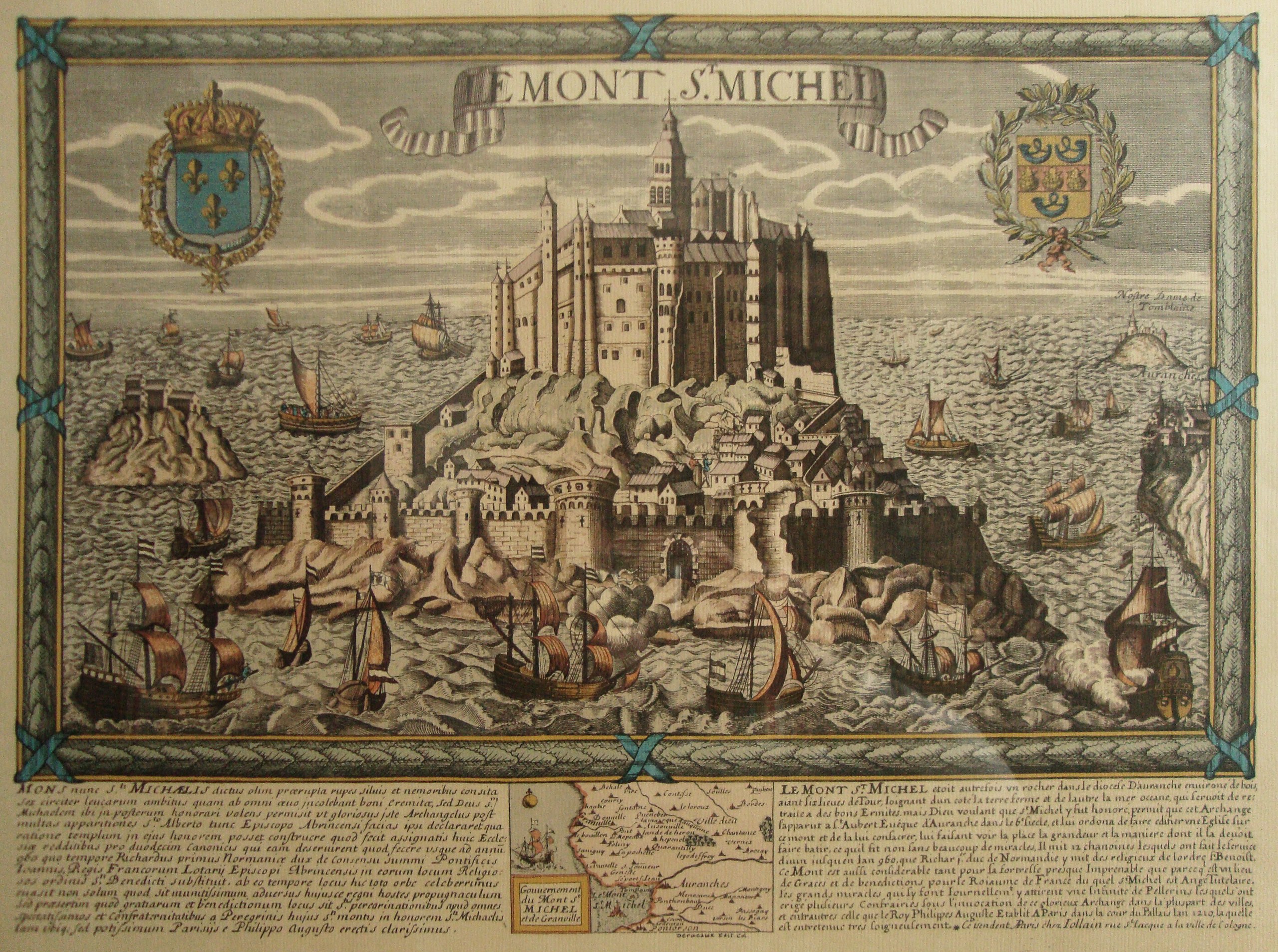
English: Le Mont St. Michel, Normandy, France. It is a map (date between late XVIII and early XIX centuries; personal library) that comprises an old view, with a bilingual historical description, of the place (Latin and French) and map. Made by Daniel Louis Derveaux (1914-2010). Although the images collected at http://en.wikipedia.org/wiki/Mont_Saint-Michel#Development suggest that this engraving is wrong due to the central and higher tower, which is represented in its actual shape in the maquette corresponding to the XX century, resembles to the present one, but not to that represented in the maquette corresponding to XVII-XVIII centuries, this engraving has to be dated so far to the last days of the monarchy in the late XVIII century, or during the brief Bourbon restoration of XIX century, due to the Royal Coat of Arms of the Kingdom of France, at the left upper corner of the engraving. Also, the image at http://www.vintage-maps.com/en/Antique-Maps/Europe/France/Merian-France-Mont-Saint-Michel-1657::401.html?XTCsid=2204da727b878fd7bc48a0c7a424cb01, which correspond to a view of the XVII century, shows the same same central and higher tower in the shape that has this uploaded image, instead of resembling that of the maquette 3, corresponding to XVII-XVIII centuries. Typographical characters suggest XVIII century.
Español: El Monte San Miguel, en Normandía, Francia. Se trata de un mapa, datable a fines del s. XVIII o a principios del s. XIX, que reune en una pieza la vista del sitio, su descripción histórica bilingüe (latín y francés), y un mapa propiamente dicho. Hecho por Daniel Louis Derveaux (1914-2010). Aunque las imágenes reunidas en http://en.wikipedia.org/wiki/Mont_Saint-Michel#Development sugieren que este grabado es apócrifo, debido a que la torre central, más alta, que es representada en su forma presente en la maqueta que corresponde al siglo XX, se asemeja a la de esta imagen, pero no a aquella representada en la maqueta que corresponde a los siglos XVII-XVIII, este grabado debería ser datado a más tardar fines del s. XVIII o, cuanto más reciente, a principios del s. XIX, por razón del escudo de armas real en la esquina superior izquierda. Además, la imagen en http://www.vintage-maps.com/en/Antique-Maps/Europe/France/Merian-France-Mont-Saint-Michel-1657::401.html?XTCsid=2204da727b878fd7bc48a0c7a424cb01 muestra la misma torre central en la figura que tiene en esta imagen, en lugar de la forma sugerida por la recreación de la maqueta 3, correspondiente a los ss. XVII-XVIII. La tipografía sugiere que es del s. XVIII. |
| Data | Without date: late XVIII century or early XIX century. Typographical characters suggest XVIII century. / Sin fecha: datable a fines del s. XVIII o a principios del s. XIX. La tipografía sugiere que es del s. XVIII. |
| Font | Treball propi;just for the photograph; it is an antique work./Trabajo propio en lo que concierne a la fotografía, pues la obra retratada es antigua. |
| Autor | Rhurtadon; but just for the photograph. Te map it self seems to be made by some Deracaux./ La obra en sí misma fue hecha por cierto Deracaux. |
| Permís (Com reutilitzar aquest fitxer) |
All granted. / Todos concedidos. |
| Posició de la càmera | | Aquesta i altres imatges properes a: OpenStreetMap |
|---|
Llicència
Jo, el titular dels drets d'autor d'aquest treball, el public sota les següents llicències:

|
S'autoritza la còpia, la distribució i la modificació d'aquest document sota els termes de la llicència de documentació lliure GNU versió 1.2 o qualsevol altra versió posterior que publiqui la Free Software Foundation; sense seccions invariants, ni textos de portada, ni textos de contraportada. S'inclou una còpia d'aquesta llicència en la secció titulada GNU Free Documentation License. |
This file is licensed under the Creative Commons Attribution-Share Alike 4.0 International, 3.0 Unported, 2.5 Generic, 2.0 Generic and 1.0 Generic license.
- Sou lliure de:
- compartir – copiar, distribuir i comunicar públicament l'obra
- adaptar – fer-ne obres derivades
- Amb les condicions següents:
- reconeixement – Heu de donar la informació adequada sobre l'autor, proporcionar un enllaç a la llicència i indicar si s'han realitzat canvis. Podeu fer-ho amb qualsevol mitjà raonable, però de cap manera no suggereixi que l'autor us dóna suport o aprova l'ús que en feu.
- compartir igual – Si modifiqueu, transformeu, o generareu amb el material, haureu de distribuir les vostres contribucions sota una llicència similar o una de compatible com l'original
Podeu seleccionar la llicència que vulgueu.
Historial del fitxer
Cliqueu una data/hora per veure el fitxer tal com era aleshores.
| Data/hora | Miniatura | Dimensions | Usuari/a | Comentari | |
|---|---|---|---|---|---|
| actual | 10:22, 28 feb 2014 | | 3.797 × 2.828 (3,11 Mo) | MartinoK | Lens correction, colour cleansing, undistorted and rotated. |
| 05:06, 11 maig 2010 |  | 4.000 × 3.000 (4,12 Mo) | Rhurtadon | {{Information |Description={{en|1=Le Mont St. Michel, Normandy, France. It is a map (date between late XVIII and early XIX centuries) that comprises an old view, with a bilingual description, of the place (Latin and French) and map. Made by some Deracaux. |
Ús del fitxer
La pàgina següent utilitza aquest fitxer:
Ús global del fitxer
Utilització d'aquest fitxer en altres wikis:
- Utilització a es.wikipedia.org
- Utilització a fr.wikipedia.org
- Utilització a uk.wikipedia.org