Fitxer:Map of Gascon campaign of 1345.svg

Fitxer original(fitxer SVG, nominalment 914 × 992 píxels, mida del fitxer: 295 Ko)

Dibuixa aquesta imatge en .
Descripció a Commons

Resum

Descripció
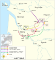
English: Map of the Gascon campaign of 1345, part of the Hundred Years' War. This map shows the English and French army movements during the campaign and the most important battles.
Català: Mapa de la campanya gascona de 1345, part de la Guerra dels Cent Anys. Aquest mapa mostra els moviments de l'exèrcit anglès i francès durant la campanya i les batalles més importants.
institution QS:P195,Q60667736
institution QS:P195,Q12551
Data
Font

Treball propi
This file was derived from:

Derived from;

Information from:

  • Sumption, Jonathan (1990). Trial by Battle. London: Faber and Faber. ISBN 978-0-571-20095-5 Derby's advance: Map 19, p 460; map 20, p 464. Louis of Poitiers' advance: p 468. Derby's advance to Auberoche: p 469. Derby's return to La Réole: p 473.
  • Burne, Alfred (1999). The Crecy War. Ware, Hertfordshire: Wordsworth Editions. ISBN 978-1-84022-210-4 Derby's retreat: p 102.
  • Requested by and knowledge from Newm30
Autor Goran_tek-en
Permís
(Com reutilitzar aquest fitxer)
w:ca:Creative Commons
reconeixement compartir igual
This file is licensed under the Creative Commons Attribution-Share Alike 4.0 International license.
Reconeixement: Goran tek-en
Sou lliure de:
  • compartir – copiar, distribuir i comunicar públicament l'obra
  • adaptar – fer-ne obres derivades
Amb les condicions següents:
  • reconeixement – Heu de donar la informació adequada sobre l'autor, proporcionar un enllaç a la llicència i indicar si s'han realitzat canvis. Podeu fer-ho amb qualsevol mitjà raonable, però de cap manera no suggereixi que l'autor us dóna suport o aprova l'ús que en feu.
  • compartir igual – Si modifiqueu, transformeu, o generareu amb el material, haureu de distribuir les vostres contribucions sota una llicència similar o una de compatible com l'original
This work contains information from OpenStreetMap, which is made available under the Open Database License (ODbL).

The ODbL does not require any particular license for maps produced from ODbL data. Prior to 1 August 2020, map tiles produced by the OpenStreetMap Foundation were licensed under the CC-BY-SA-2.0 license. Maps produced by other people may be subject to other licences.

Altres versions
SVG genesis
InfoField
 
El codi font d'aquest SVG és vàlid.
 
Aquesta imatge vectorial ha estat creada amb Inkscape.
Posició de l'objecte45° 19′ 40,8″ N, 0° 22′ 12,72″ O Kartographer map based on OpenStreetMap.Aquesta i altres imatges properes a: OpenStreetMapinfo

Llegendes

Mapa de la campanya gascona de 1345, emmarcada en la Guerra dels Cent Anys

Elements representats en aquest fitxer

representa l'entitat

45°19'41"N, 0°22'12"W

Historial del fitxer

Cliqueu una data/hora per veure el fitxer tal com era aleshores.

Data/horaMiniaturaDimensionsUsuari/aComentari
actual09:49, 2 oct 2023Miniatura per a la versió del 09:49, 2 oct 2023914 × 992 (295 Ko)LalpinoFile uploaded using svgtranslate tool (https://svgtranslate.toolforge.org/). Added translation for ca.
21:53, 9 nov 2021Miniatura per a la versió del 21:53, 9 nov 2021914 × 992 (224 Ko)Goran tek-enView box, font size, color deficiency
19:56, 19 nov 2018Miniatura per a la versió del 19:56, 19 nov 2018914 × 993 (128 Ko)Goran tek-en{{Information |description ={{en|1=Map of the Gascon campaign of 1345, part of the Hundred Years' War. This map shows the English and French army movements during the campaign and the most important battles.}} |date = |source ={{Own}}<br> Derived from; * [https://www.openstreetmap.org/#map=8/44.678/-0.324 OSM] Information from: * [https://thehistoryofengland.co.uk/2013/09/29/104-lancaster-and-the-battle-of-auberoche/ The history of England] * {{U|Newm30}} |author...

La pàgina següent utilitza aquest fitxer:

Ús global del fitxer

Metadades