Fitxer:Map of the Territory of the Parisii.svg

Mida d'aquesta previsualització PNG del fitxer SVG: 424 × 600 píxels. Altres resolucions: 170 × 240 píxels | 339 × 480 píxels | 543 × 768 píxels | 724 × 1.024 píxels | 1.448 × 2.048 píxels | 744 × 1.052 píxels.
Fitxer original (fitxer SVG, nominalment 744 × 1.052 píxels, mida del fitxer: 148 Ko)
| Aquest fitxer i la informació mostrada a continuació provenen del dipòsit multimèdia lliure Wikimedia Commons. |
| Descripció |
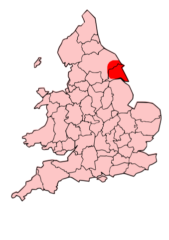
English: A map showing the territory of the Dobunni tribe overlayed in red in the context of the modern county boundaries of England and wales Image depicting the Celts of North and Midland England, pre-Roman Britain times. I created this myself, under the guidance (to find location of them) of Roman-Britain.org |
| Data | (UTC) |
| Font | |
| Autor |
|
.svg)
.png)
| Això és una imatge retocada, cosa que vol dir que ha estat alterada digitalment de la seva versió original. Modificacions: Modified county map with overlay of territory of parisii. L'original es pot veure a: England Celtic tribes - North and Midlands.png:
|
Aquest fitxer està subjecte a la llicència de Creative Commons Reconeixement i Compartir Igual 3.0 No adaptada.
- Sou lliure de:
- compartir – copiar, distribuir i comunicar públicament l'obra
- adaptar – fer-ne obres derivades
- Amb les condicions següents:
- reconeixement – Heu de donar la informació adequada sobre l'autor, proporcionar un enllaç a la llicència i indicar si s'han realitzat canvis. Podeu fer-ho amb qualsevol mitjà raonable, però de cap manera no suggereixi que l'autor us dóna suport o aprova l'ús que en feu.
- compartir igual – Si modifiqueu, transformeu, o generareu amb el material, haureu de distribuir les vostres contribucions sota una llicència similar o una de compatible com l'original
Registre original de càrregues
This image is a derivative work of the following images:
- File:Map_of_the_Territory_of_the_Dobunni.svg licensed with Cc-by-sa-3.0, GFDL
- 2009-10-13T19:47:34Z Jpb1301 744x1052 (151192 Bytes) {{Information |Description={{en|1=A map showing the territory of the Dobunni tribe overlayed in red in the context of the modern county boundaries of England and wales}} |Source=*[[:File:Map_of_the_Territory_of_the_Dobunni.sv
- 2009-10-13T17:38:36Z Jpb1301 744x1052 (151194 Bytes) {{Information |Description={{en|1=A map showing the territory of the Dobunni tribe overlayed in red in the context of the modern county boundaries of England and wales}} |Source=*[[:File:Map_of_the_Territory_of_the_Cornovii_(
- File:England_Celtic_tribes_-_North_and_Midlands.png licensed with Cc-by-sa-3.0
- 2009-07-29T23:43:34Z Thomas Gun 296x495 (27459 Bytes) == Summary == {{Information |Description=Image depicting the Celts of North and Midland England, pre-[[Roman Britain]] times. I created this myself, under the guidance (to find location of them) of [http://www.roman-britain.o
Uploaded with derivativeFX
Historial del fitxer
Cliqueu una data/hora per veure el fitxer tal com era aleshores.
| Data/hora | Miniatura | Dimensions | Usuari/a | Comentari | |
|---|---|---|---|---|---|
| actual | 22:16, 16 oct 2009 | | 744 × 1.052 (148 Ko) | Jpb1301 | {{Information |Description={{en|1=A map showing the territory of the Dobunni tribe overlayed in red in the context of the modern county boundaries of England and wales}}Image depicting the Celts of North and Midland England, pre-Roman Britain times. I |
Ús del fitxer
La pàgina següent utilitza aquest fitxer:
Ús global del fitxer
Utilització d'aquest fitxer en altres wikis:
- Utilització a cy.wikipedia.org
- Utilització a en.wikipedia.org
- Utilització a fi.wikipedia.org
- Utilització a fr.wikipedia.org
- Discussion:Parisii
- Parisii (Grande-Bretagne)
- Wikipédia:Statistiques des anecdotes de la page d'accueil/Visibilité des anecdotes (2020)
- Discussion:Parisii/LSV 17690
- Wikipédia:Statistiques des anecdotes de la page d'accueil/Visibilité des anecdotes (2020)/2020 02
- Projet:Aide et accueil/Twitter/Tweets/archives/février 2020
- Wikipédia:Le saviez-vous ?/Archives/2020
- Utilització a la.wikipedia.org