Fitxer:Map of the flooding areas of the Lake Nasser in the Wadi Halfa Salient.png

Mida d'aquesta previsualització: 571 × 600 píxels. Altres resolucions: 228 × 240 píxels | 457 × 480 píxels | 909 × 955 píxels.
Fitxer original (909 × 955 píxels, mida del fitxer: 1,25 Mo, tipus MIME: image/png)
| Aquest fitxer i la informació mostrada a continuació provenen del dipòsit multimèdia lliure Wikimedia Commons. |
| Descripció |
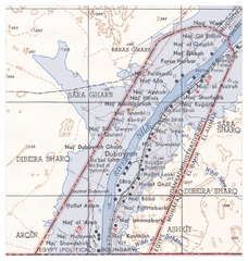
Deutsch: Überflutungsgebiet des Nasser-Stausees im Wadi Halfa Salient
English: Flooding areas of the Lake Nasser in the Wadi Halfa Salient |
||||||
| Data | see file history | ||||||
| Font |
own work, using the following files:
|
||||||
| Autor | Maximilian Dörrbecker (Chumwa) | ||||||
| Permís (Com reutilitzar aquest fitxer) |
Jo, el titular dels drets d'autor d'aquest treball, el public sota la següent llicència: Aquest fitxer està publicat sota la llicència de Creative Commons Reconeixement i Compartir Igual 2.5 Genèrica.
|
||||||
| Altres versions |
|


Historial del fitxer
Cliqueu una data/hora per veure el fitxer tal com era aleshores.
| Data/hora | Miniatura | Dimensions | Usuari/a | Comentari | |
|---|---|---|---|---|---|
| actual | 08:25, 20 juny 2009 | | 909 × 955 (1,25 Mo) | Chumwa | {{Information |Description={{de|Überflutungsgebiet des Nasser-Stausees im Wadi Halfa Salient}} {{en|Flooding areas of the Lake Nasser in the Wadi Halfa Salient}} |Source=own work, using the following files: * [[:File:Wadi Halfa Salient-txu-oclc-6949452- |
Ús del fitxer
La pàgina següent utilitza aquest fitxer:
Ús global del fitxer
Utilització d'aquest fitxer en altres wikis:
- Utilització a ar.wikipedia.org
- Utilització a bg.wikipedia.org
- Utilització a de.wikipedia.org
- Utilització a el.wikipedia.org
- Utilització a en.wikipedia.org
- Utilització a fr.wikipedia.org
- Utilització a id.wikipedia.org
- Utilització a it.wikipedia.org
- Utilització a ja.wikipedia.org
- Utilització a nl.wikipedia.org