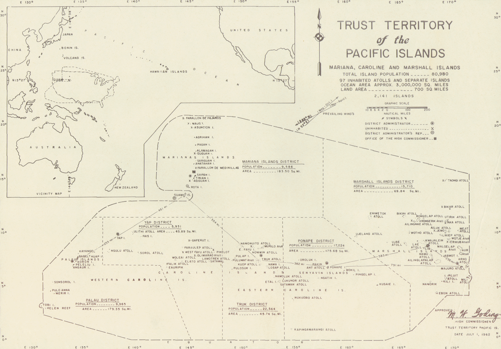
Fitxer:MapofTTPI.gif
Mida d'aquesta previsualització: 800 × 557 píxels. Altres resolucions: 320 × 223 píxels | 640 × 446 píxels | 1.024 × 713 píxels | 1.280 × 891 píxels | 2.055 × 1.431 píxels.
Fitxer original (2.055 × 1.431 píxels, mida del fitxer: 1,11 Mo, tipus MIME: image/gif)
| Aquest fitxer i la informació mostrada a continuació provenen del dipòsit multimèdia lliure Wikimedia Commons. |

|
Aquesta imatge (de tipus mapa) s'hauria de tornar a crear utilitzant gràfics vectorials com ara un fitxer SVG. Això té diversos avantatges; en trobareu més informació a Commons:Media for cleanup. Si ja disposeu d'una versió d'aquesta imatge en format SVG, us preguem que la pengeu; després, reemplaceu aquesta plantilla amb la plantilla {{Vector version available|nom nou de la imatge.svg}} en aquesta imatge.
|
Resum
![[1]](https://web.archive.org/web/20020605063920/http://libweb.hawaii.edu/ttp/images/1962full.gif)
Llicència
| This work is from the Library of Congress. According to the library, there are no known copyright restrictions on the use of this work. |  |
Historial del fitxer
Cliqueu una data/hora per veure el fitxer tal com era aleshores.
| Data/hora | Miniatura | Dimensions | Usuari/a | Comentari | |
|---|---|---|---|---|---|
| actual | 01:20, 20 jul 2010 | | 2.055 × 1.431 (1,11 Mo) | Beao | Removed border. |
| 01:49, 20 març 2005 |  | 2.128 × 1.600 (1,29 Mo) | Hoshie | Map of the TTPI. From [http://web.archive.org/web/20020605063920/http://libweb.hawaii.edu/ttp/images/1962full.gif]. {{PD-USGov}} |
Ús del fitxer
La pàgina següent utilitza aquest fitxer:
Ús global del fitxer
Utilització d'aquest fitxer en altres wikis:
- Utilització a azb.wikipedia.org
- Utilització a be.wikipedia.org
- Utilització a bg.wikipedia.org
- Utilització a cs.wikipedia.org
- Utilització a de.wikipedia.org
- Utilització a en.wikipedia.org
- Utilització a eo.wikipedia.org
- Utilització a es.wikipedia.org
- Utilització a fa.wikipedia.org
- Utilització a fr.wikipedia.org
- Utilització a ha.wikipedia.org
- Utilització a he.wikipedia.org
- Utilització a hr.wikipedia.org
- Utilització a hu.wikipedia.org
- Utilització a id.wikipedia.org
- Utilització a it.wikipedia.org
- Utilització a ja.wikipedia.org
- Utilització a ko.wikipedia.org
- Utilització a lt.wikipedia.org
- Utilització a mk.wikipedia.org
- Utilització a no.wikipedia.org
- Utilització a pl.wikipedia.org
- Utilització a ru.wikipedia.org
- Utilització a test.wikipedia.org
- Utilització a uk.wikipedia.org
- Utilització a vi.wikipedia.org
- Utilització a zh.wikipedia.org